Notice: I've taken a part-time job, and it's definitely affecting my blogging time. I'll continue to add content here as often as possible. Pertinent guest posts are always welcome.

-
Showing posts with label mineral extraction. Show all posts

Wednesday, December 14, 2011

Still Time to Comment on Hydrofracking in New York

alt text
how the Marcellus Shale is located in relation to the North Country Trail. Right click the map to enlarge or follow the FLT link below to see the full-size version (graphic from the Finger Lakes Trail Conference)


based on a press release from the New York DEC

In New York City, on November 30, the New York State Department of Environmental Conservation held its fourth and final public hearing on the agency's draft SGEIS, draft regulations and draft stormwater permit for high-volume hydraulic fracturing. Previous hearings were held in Dansville, Binghamton and Loch Sheldrake.

In total, approximately 6,000 people attended the hearings, which each had an afternoon and evening session, and approximately 590 people gave verbal comments. An additional 669 written comments were also submitted at the hearings.

Hydrofracking will have a strong impact on the North Country Trail simply because the Marcellus Shale bed underlies so much of the area through which the trail passes.

"The turnout of 6,000 people at the hearings demonstrates how strongly New Yorkers feel about this important issue," DEC Commissioner Joe Martens said. "Nearly 600 individuals took the time to voice their opinions."

"I appreciate the public's unprecedented attendance and attention to this issue. The comments made at the hearings will be seriously considered as we move forward with developing the final rules and conditions. I encourage New Yorkers to continue to read the documents and submit their feedback to DEC before the comment period ends on January 11."

See to submit comments on High-Volume Hydraulic Fracturing

This affects all FLT maps M1-M33 and NCTA map PA-01, 02, 03

See Marcellus Shale Gas Drilling and the NCT


Tuesday, December 13, 2011

Continuing Mineral Extraction Controversy in the Allegheny National Forest

alt text
Allegheny National Forest Hills in autumn (photo by jhy)

based on news articles in the Pittsburgh Post-Gazette: In Rebuttal / Two different standards and Stand up for states' rights

The problems of mineral and timber extraction in the Allegheny National Forest of Pennsylvania are an old and bitter news item. For the issues of oil and gas drilling the problem is intensified by the fact that the Forest does not own the sub-surface rights. Thus, the government has no legal right to prevent the industry from taking what is legally theirs.

Problems arise, however, due to the fact that oil wells, tanks, roads and pipelines have to be built on the surface in order to extract the minerals. This infrastructure does intrude on the landscape that belongs to the National Forest. Many law suits over these issues have been brought over the years. With the recent hoopla about the potential for the development of the Marcellus Shale, and hydrofracturing processes, the issue is hot once again.

Because there are nearly 100 miles of North Country Trail within the Allegheny National Forest, the trail is often impacted.

The legal issues surrounding the Allegheny battles are much more complex than recreation vs industry. Two-century-old laws concerning the acquisition and uses of federal land come into play. Recently the U.S. Third Circuit Court of Appeals held that the Allegheny National Forest has almost no authority to permit (or not) the surface infrastructure needed to extract sub-surface minerals.

Those who feel that the modern recreational uses of National Forests is paramount in importance are outraged.

The battle goes on. Meanwhile, be prepared to see plenty of oil and gas rigs in Pennsylvania and Ohio along the trail.

This segment is on NCTA map PA-01

See Allegheny National Forest Chapter of the NCTA


Monday, August 22, 2011

Opinions on Taconite Mining in Wisconsin

{EAV_BLOG_VER:dd07b9f10488db83} just ignore this verification code for Empire Avenue, please

taconite mine tailings
taconite mine tailings in Minnesota (photo by jhy)

received from Mike Stafford, President, Heritage Chapter of the NCTA

The proposed mine along the Heritage section of the North Country Trail appeared to be on hold a few weeks ago when GTAC stopped public-view pursuit of it. Now that the recall elections are mostly complete it appears that the state senate is again ready to consider relaxing current environmental protection laws to shorten and hasten the regulatory approval (per Senator Fitzgerald in an interview this morning). The North Country Trail Association does not take a position on whether the mine should or should not be approved. However, as individual volunteers, I ask that you consider joining me in asking your legislator to at least respect the environmental and regulatory laws that are currently on the books. These laws and regulations were a long time in development. Certainly laws can and should be changed with careful and thoughtful consideration, but it seems inappropriate to quickly and drastically change laws to relax regulations at the request of one special interest.


You may have already seen this, but below is a letter from a former mine supporter describing how and why he changed his mind regarding the mine. Charles Ortman runs a business in the area and was willing to step forward and make the statements below:

I don't take pleasure in delivering the following news. I was initially a strong
advocate of the Gogebic Taconite (GTAC) mine.

Fortunately I don't like to make decisions before informing myself. So after three months of digging I sadly report the following to you. If you are skeptical of my data I encourage you to go to the Iron Range and check for yourself every one of my claims. I would be happy to be wrong.

GTAC will make our fish inedible (fisherman take heed), kill our wild rice (duck hunters and ricers take heed), sterilize our rivers and lakes (water enthusiasts take heed). Have I got your attention? Good because its all true.

Even though taconite mining is not sulfide mining it still creates a sulfide and mercury pollution cycle. This cycle is unequivocally incompatible with fresh water. When sulfates enter the water they are acted on by a sulfide eating bacteria that turns mercury into methyl-mercury. This is the kind of mercury that gets transferred up the food chain and accumulates in the tissue of fish. It is the kind of mercury that turns into "do not eat fish from this body of water" warnings.

"Do not eat fish from this body of water" are the warnings you will be seeing on fish in the Chequamegon Bay and rivers affected by the GTAC pit mine. High sulfate levels and mercury is what killed over 100 miles of the St. Louis River to wild rice and is responsible for the inedibly high levels of mercury in the fish. High sulfate levels are slowly poisoning lakes and waterways throughout the Iron Range and it is caused by taconite mining.

Taconite tailings ponds on the Iron Range that are leaking (and they all leak, even the best of them) have been draining into the Partridge River for years. There are sulfates and mercury in this leakage. Once a river's sulfate level reaches a certain point, somewhere around 10 parts per million, the sulfate-eating bacteria get going and part of this byproduct is the methyl-mercury that gets into the fish and hydrogen sulfide which prevents wild rice from growing.

What we have now in the Penokees is a fish and wildlife factory as well as a water purification system that you couldn't buy for any amount of precious
metals under it.

Citizens of Ashland and the surrounding community, don't trade the golden goose for a mercury egg! Demand your local and state politicians put an end to this
water killer right now. Demand that GTAC pack up the boring equipment and move along. We prefer our clean water.

Signed,
Charles Ortman
Ashland
Can you help to join the fight to let the legislators know that the existing mining laws need to be enforced? A letter that you can use is attached. Please personalize the letter if you wish. If you don't know your Senator or Assembly person, use this link to find who they are: Wisconsin Legislators

Protecting the Northwoods is something we all need to participate in. Please take time to send your legislator an message via email, fax or hard copy. They need to hear from you.

Thank you in advance for helping to protect the Northwoods.

Michael J Stafford, President Heritage Chapter of the NCTA

This segment is on NCTA map WI-01

See Heritage Chapter of the NCTA

Saturday, April 16, 2011

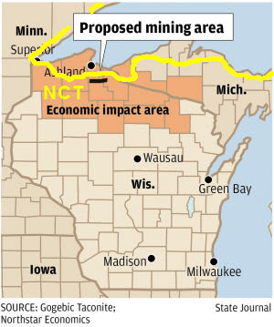
Proposed Taconite Mining Very Near NCT in Wisconsin

map of NCT in Wisconsin near iron deposits


based on a news article at the Wisconsin State Journal

NorthStar Economics, of Madison, Wisconsin, announced in April that a taconite mine is being proposed near Ashland. If the Gogebic Taconite (GTac) mine were built, at an estimated cost of $1.5 billion, the two-year construction period alone would create 3,175 jobs and $20.6 million in state and local tax revenue. The estimated life of the mine could be 35 years, a huge economic impact.

While this would be quite a boost to the local economy, there are environmental issues to balance the question. Ann Coakley, director of waste and materials management for the Wisconsin Department of Natural Resources, pointed out that there would need to be extensive environmental review. Impacts on surface and ground water, wildlife, threatened and endangered species, and air pollution would all need to be evaluated.

Any sections of the North Country National Scenic Trail which are certified will have a certain level of standing which also will need to be taken into account. Mellen, Wisconsin, is usually considered to be the first ever "Trail Town" along the NCT, and Gogebic Taconite holds an option to lease a 22-mile stretch between Mellen and Upson. Upson is just northeast of Mellen, and the North Country Trail traverses a ridge on the north edge of this entire stretch before entering Copper Falls State Park and then heading south into Mellen.


This segment is on NCTA map WI-01

See Chequamegon Chapter of the NCTA

Wednesday, March 31, 2010

Marcellus Shale Gas Drilling and the NCT

NCT and Marcellus Shale
how the Marcellus Shale is located in relation to the North Country Trail. Right click the map to enlarge or follow the FLT link below to see the full-size version (graphic from the Finger Lakes Trail Conference)

OutdoorBlips: vote it up!
if you like this article, click the Blip chiclet!
from several sources

The Marcellus Shale is a geological formation in a large part of New York and Pennsylvania. The proposals to extract gas from this layer are being scrutinized closely by New York, and less carefully by Pennsylvania.

The extraction method will be hydraulic fracturing, also called fracking. This involved boring horizontal tunnels, and injecting water under pressure until the rock fractures, releasing the gas. The Marcellus Shale is about 6000 feet below the surface. There have been reported problems with the method in Wyoming, where it is being blamed for aquifer contamination.

If drilling is allowed it is highly likely that it will impact the North Country Trail in multiple locations.

Retired Pennsylvania DCNR Policy Director, Rick Carlson, supported a temporary moratorium, and the passage of HB 2235, which will temporarily stop new leasing of State Forest land while the potentially harmful effects on land and waters are studied.

New York has prohibited the practice in the New York City watershed, essentially the Catskills.

The Finger Lakes Trail Conference has offered a position paper on Marcellus Shale drilling. It states: "The draft SGEIS [Supplemental Generic Environmental Impact Statement] characterizes “trails” as “visual features”. However, the FLT is much more than a passive visual feature; it is a long distance, wilderness character footpath, and provides numerous benefits to people across the state and for out of state visitors. The simple application of “line of sight” and “view shed” criteria does not provide adequate protection of these benefits. Although the occasional vistas do provide long views of the surrounding countryside, much of the appeal of the trail is in the active, physical involvement with close-by sights, sounds, smells, and the overall experience of being in a natural setting." It includes a 9-point list of reasons the FLTC opposes the drilling. These are:
  • Dilution of trail resources
  • Loss of wilderness
  • Loss of trail quality
  • Loss of trail continuity
  • Loss of membership
  • Hiker safety
  • Landowner relationship degredation
  • Increased motorized use
  • Reduced likelihood of permanent protection


This affects all FLT maps M1-M33 and NCTA map PA-01, 02, 03

The entire FLTC statement can be read at Comment on the [Draft] Supplemental Generic Environmental Impact Statement

Sunday, March 8, 2009

Yellow Dog Mine Receives Favorable Ruling

Yellow Dog Mine site
approximate location of the Yellow Dog Mine
based on news from M-Live.com and the Lansing City Pulse

A small, but high-grade vein of nickel is located under Yellow Dog Plain, west of Marquette in Michigan's Upper Peninsula. The proposed mine site is located just a few miles from the route of the North Country Trail.

This proposal stirred up "a bitter conflict that has already reverberated up and down the state of Michigan. Scarred by accidents in other states and provisionally banned by Wisconsin, sulfide mining - a process with a hotly debated safety record - is poised to tunnel into Michigan, starting at the state's remotest, most mineral-rich outpost."

The London-based Kennecott company, which would create the mine, states that waste handling has come a long way from the days when nickel mining, with its deadly sulfides turned whole regions into moonscapes. Anyone who visited Sudbury, Ontario 20 or more years ago knows that this description is no exaggeration. Activists point out that a dismal record at containment should make the choice easy... keep the mine out. "In April 1998, partially in response to public concern over Kennecott's problem-plagued Flambeau Mine, Wisconsin passed a sulfide mining moratorium that requires permit applicants to show one example of a mining operation in the United States or Canada that has operated for 10 years - and one that has been closed for 10 years - without causing significant environmental pollution. It's a test no company, including Kennecott, has yet met."

At the heart of the debate is the potential damage to surrounding water resources, and particularly the effect on the coaster brook trout, a species being brought back from near extinction, and highly popular with anglers.

Now, a judge has ruled that the lease for the surface operations of the mine can be issued. Ingham County Circuit Judge Paula Manderfield dismissed a lawsuit by opponents of the mine. She stated that the DNR had acted legally, and within its authority to grant the lease.

The National Wildlife Federation points out that the ruling was made on the legality of the jurisdiction rather than the merits of the lease. Opponents also have challenged the Department of Environmental Quality's issuance of permits to build and operate the mine and to discharge treated wastewater.

The lawyer for the NWF also stated that the ruling on the surface lease has no bearing on the case concerning the actual mine construction. Also fighting the lease are the Yellow Dog Watershed Preserve, the Keweenaw Bay Indian Community and the Huron Mountain Club, an exclusive retreat near the proposed mine site.

If approved, this will be the only U.S. mine where nickel is the primary mineral produced. The targeted deposit is expected to yield 300 million pounds of nickel, 250 million pounds of copper and trace amounts of other minerals. Because the metals are within sulfide ore bodies, critics fear the mine will generate sulfuric acid and contaminate rivers and groundwater in the area, which is within the Lake Superior watershed.

Kennecott-Eagle is still waiting for approval of an underground wastewater discharge permit from the EPA.

See "Judge OKs lease of state land for UP mine"