Notice: I've taken a part-time job, and it's definitely affecting my blogging time. I'll continue to add content here as often as possible. Pertinent guest posts are always welcome.

-

Saturday, April 16, 2011

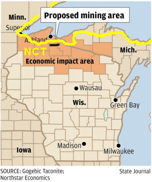
Proposed Taconite Mining Very Near NCT in Wisconsin

map of NCT in Wisconsin near iron deposits


based on a news article at the Wisconsin State Journal

NorthStar Economics, of Madison, Wisconsin, announced in April that a taconite mine is being proposed near Ashland. If the Gogebic Taconite (GTac) mine were built, at an estimated cost of $1.5 billion, the two-year construction period alone would create 3,175 jobs and $20.6 million in state and local tax revenue. The estimated life of the mine could be 35 years, a huge economic impact.

While this would be quite a boost to the local economy, there are environmental issues to balance the question. Ann Coakley, director of waste and materials management for the Wisconsin Department of Natural Resources, pointed out that there would need to be extensive environmental review. Impacts on surface and ground water, wildlife, threatened and endangered species, and air pollution would all need to be evaluated.

Any sections of the North Country National Scenic Trail which are certified will have a certain level of standing which also will need to be taken into account. Mellen, Wisconsin, is usually considered to be the first ever "Trail Town" along the NCT, and Gogebic Taconite holds an option to lease a 22-mile stretch between Mellen and Upson. Upson is just northeast of Mellen, and the North Country Trail traverses a ridge on the north edge of this entire stretch before entering Copper Falls State Park and then heading south into Mellen.


This segment is on NCTA map WI-01

See Chequamegon Chapter of the NCTA

Tuesday, April 12, 2011

Encampment River Bridge Update

broken Encampment River Bridge
site of former Encampment River Bridge

from Gayle Coyer, Executive Director, Superior Hiking Trail Association

The news about the Encampment River bridge is not good. When the huge ice jam hit the bridge it tipped the middle crib over. As the bridge broke apart in the middle (as it is designed to do) the ice snapped the cable for both pieces and they went down the river. One half was several hundred feet downstream and Han was going in there today to try to secure it. The other half is gone completely, maybe all the way down to Lake Superior. With the river still high and road restrictions on, we don't know when we will be able to replace the bridge.

The ice buildup was from a freaky situation where we got a hard rain on Dec. 31st which brought the water up really high. Then a new layer of ice formed about 3 or 4 feet above the old layer. So instead of about 1 foot of ice they ice was 3-4 feet thick. It was this thick ice that took the bridge out, even though the bridge was raised a couple of feet when we rebuilt the cribs and ramps last October.

The Encampment River bridge is located about in the middle of the section of Co Rd 301 (Fors Rd) to Castle Danger. Here are the directions for a roadwalk:

From Co Rd 301 (Fors Rd) take the SHT 0.4 miles until it crosses Co Rd 3 (Hwy 3). Turn left (north) and go 4.7 miles to West Castle Danger Road (this road does not have a green sign but there is a bright blue sign that says "To Hwy 61" with a right arrow). Turn right (east) and go 1.6 miles to where SHT crosses road. Go left on SHT 0.1 miles to Castle Danger Trailhead parking lot.

This segment is on SHTA map 1

See Superior Hiking Trail Association

Monday, April 11, 2011

Encampment River Bridge Destroyed Again

Encampment River Bridge destroyed
where the new Encampment River Bridge used to be

from the Superior Hiking Trail Association

The new Encampment River bridge built in 2010 was pushed downstream by an ice dam this past weekend. This is on the Superior Hiking Trail in a section not far north of Two Harbors.

This is an extremely difficult place for a bridge as one bank of the river is high, and one is low. The past bridges descended a long cleated ramp to reach the bridge decking which was about 5 feet above summer water level.

However, a continual problem along the North Shore (of Lake Superior) is that in the spring water is high, filled with ice floes, and the valleys are narrow. Bridges are often damaged or swept away. Many of the smaller bridges have been cabled to trees on one bank so that if they are broken loose in the spring the bridge may be turned sideways, but may be salvaged for re-placement.

Encampment River, however, is a major bridge. It is not known at this time if the bridge can be salvaged. It's a shame, since it was finally replaced last year, after many seasons of being in a damaged and dangerous state.

One has to wonder if it might be worth the expense to build a high bridge from the upper bank, with stairs descending to the lower bank. The ice could still attack the footings, but it wouldn't present the whole stringer/decking system to the pressure of jammed ice being carried downstream.

This segment is on SHTA map 1

See Encampment River Bridge Repaired

Thursday, April 7, 2011

Michigan to Close Two Campsites Important to the NCT

sandhill cranes
sandhill cranes displaying at Big Lake (photo by jhy)

based on a news release of the Michigan DNR

Cara Boucher, assistant chief of the DNR's Forest Management Division, said, "Given the long-term trend of declining use and the inability to raise camp fee revenues, the only way to absorb the current cut in General Fund support is to close some campgrounds."

The order to close the 23 campgrounds will be submitted as a proposal at today's Michigan Natural Resources Commission (NRC) meeting in Lansing, and will be eligible for action by DNR Director Rodney Stokes at the NRC's May 12 meeting in Flint. If approved at the May meeting, the closures would be effective on May 19, 2011.

Two Upper Peninsula State Forest Campgrounds on the list are ones which can be used by hikers of the North Country Trail. Having places where camping is allowed is important for long-distance hikers.

Most surprising to me is Big Lake in Baraga County. This is a botanical treasure. When I was there in July of 2005, the beach edge was covered with several species of rare plants. We were serenaded by the Sandhill Cranes.

Reed and Green campground in Luce County is a tiny site which adds a key camping location between Culhane Lake and Muskelonge State Park.

Can the costs of servicing a latrine and a hand pump twice a year be so burdensome that even though these sites aren't used very much, everyone who does use them needs to be punished?

These sites are on NCTA maps MI-09 and MI-13

Monday, April 4, 2011

Volunteer Opportunity in Minnesota Arrowhead

Trimble GPS unit in a backpack
Howard Beye carrying a Trimble GPS unit (photo by jhy)

from Matt Davis Regional Trail Coordinator for MN & ND, North Country Trail Association

Cory Mensen, the Trails/Volunteer Coordinator (West Zone) for the Superior National Forest writes, "We do not have a survey for the Kek. I am hoping to get a good layer of the Kek this summer if I do I will let you know... If you know of someone hiking one our wilderness trails I can give them a quick training with a Trimble that we have and they can gather some useful information for all of us....

The "Kek" is the Kekekabic Trail, the western portion of the NCT route across the Minnesota Arrowhead, about 45 miles.

Matt adds: "Here is a volunteer opportunity for anyone who is interested in hiking the Kek or Border Route Trail this year. The U.S. Forest Service could really use someone detail-oriented and interested in GPS to record some data on the Trail. They'll provide the training and the GPS unit."

Contact Matt Davis Regional Trail Coordinator for MN & ND, North Country Trail Association


Saturday, April 2, 2011

NCTA Posts Communication Tech Position

alt text

a news release of the North Country Trail Association

The North Country Trail Association is seeking a qualified and motivated communications technician to support website design and content management, social networking, graphic design, and public relations efforts. Additional responsibilities may include media management. Works closely with NCTA’s senior management team in supporting marketing, public relations, promotions and other communications-related activity. Person will need to physically work in Lowell, Michigan. (not a remote work opportunity)

The Communications Technician is a key member of the NCTA family and team. NCTA is a small, not-for-profit membership organization serving chapters and members throughout the seven-state region of America’s northern heartland. When completed the North Country National Scenic Trail will be the premier footpath wandering through 4600 miles of scenic, historic and natural wonder, uniting America’s Red Plaid Nation.

A competitive salary with benefits options is available. A resume, list of references and cover letter addressing qualifications should be submitted by April 15 to:

HR Department
North Country Trail Association
229 East Main St.
Lowell, MI 49331

See complete details for Communication Technician job posting
Contact hr@northcountrytrail.org

Tuesday, March 29, 2011

Trailspotters Offers Discounted Tickets for NCT Members

alt text

received from Tom Funke

Trailspotters is a Michigan corporation that owns and operates shuttle and carspotting services for quiet sports enthusiasts. We operate in the eastern Upper Peninsula serving the North Country Trail between Munising and Lower Tahquamenon Falls.

The walk-up rate for a shuttle between Munising and Grand Marais is $20. A NCT chapter member covered under this agreement would be $7.50.

I would like to offer an opportunity for your chapter, for an exchange of advertising services in your newsletter and/or website, to secure a discount for your members. I'm offering 50% off for any chapter member using our services on the North Country Trail during our 2011 season, which runs from mid-June through Labor Day. Â I will also donate $100 to the chapter that has the most members using our service in 2011 (Minimum 20 total users from all chapters combined).

I am a long time member of the North Country Trail and author of 50 Hikes in Michigan's Upper Peninsula. This business opportunity presented itself because of my love of the trail.

If you are interested in taking advantage of this offer, all I need is a simple agreement, given below, to be signed and mailed or scanned/emailed back to me no later than May 15, 2011. When I receive the agreement, I'll email the Trailspotter logo and some example text, along with a code to be used when registering online

See Trailspotters of Michigan

Friday, March 11, 2011

Sam Gardner Leaves Trail with Hip Problem

Sam Gardner

compiled from Sam Gardner's journal

On January 1, Sam Gardner left Crown Point, New York on what he hoped would be a 12,500-mile trek. He planned to hike the North Country, Pacific Crest, Continental Divide, and Appalachian National Scenic Trails in one huge walk.

However, tendonitis in a hip has forced him to take a break. Sam reached Portageville, in western NY, and has returned home, to Houghton, Michigan, for medical treatment and therapy.

The pain in his hip had reduced him to completing only about six miles a day- not nearly enough to stay on a resupply schedule for his long trek.

He writes on March 6, "Today I made a very hard decision. I have chosen to leave the trail to seek medical care. The tendentious in my hip has only gotten worse in the past month. Every day i cover less and less miles before the inflammation triggers enough pain to stop me in my tracks. I was hoping to take care of this on the trail but I believe it’s well beyond that point."

This morning, he posted from home, "[The chiropractor says] my pelvis is out of alignment big time. The bad news is that it could take 6 months of physical therapy. I sincerely hope that his estimate is wrong by a long shot. I am super bummed. There is no doubt about it. However I’m doing my best to work around it. I’ve been scheming all night. So I’m coming up with a plan."

We'll have to stay tuned to see what Sam decides to do.

You can follow his journey at The Initiative

Monday, February 21, 2011

NCTA Unveils New Website

NCTA web site home page

received from Andrea Ketchmark

The new and improved northcountrytrail.org is online. Check it out and you will find a new look, more detailed trail information, better volunteer resources and greater functionality and navigability. Best of all, we see this as the next step in building a seamless national and chapter web presence, owned and updated by the membership, with huge potential for member and chapter engagement.

With the leadership of Matt Rowbotham, this process has engaged the entire staff, our Board of Directors and many chapter leaders and volunteers along the way. We hope you like what you see but the great thing about this new system is the way it provides for endless customization and the ability to be as flexible as we need to be. It is not a finished product in the traditional sense but rather a dynamic tool for communication that can meet our needs as quickly as those needs change.

Pay special attention to the new Chapter/Affiliate/Partner portal pages, a new exciting feature to insure you get the recognition you deserve on the national level. We will be contacting you all in the coming months in an effort to gather your thoughts and ideas to make these pages even better.

So for now, take a few minutes to explore northcountrytrail.org and all of its new features. Let us know what you think, what you like and what else you would like to see. And please help us get the word out by including an announcement in your newsletter or at your next meeting.

We hope you enjoy it!

Andrea Ketchmark
Director of Trail Development

See North Country Trail Association

Wednesday, February 16, 2011

Calhoun County Trailway Possible Route Needs Support

hikers on the North Country Trail

by Tom Garnett and Mick Hawkins, of the Chief Noonday Chapter, NCTA

The Calhoun County Board of Commissioners will decide soon the fate of the Calhoun County Trailway in Emmett Township on the east side of Battle Creek, and with it part of the fate of the North Country Trail. Very likely the CCTA trail would replace pretty much all of the roadwalk currently in place from the east boundary of Battle Creek down to Historic Bridge Park in Emmett Township.

A Master Plan was completed in 2006, and grants have been obtained in the past two years through the work of the Calhoun Country Trailway Alliance (CCTA) to build 5.3 miles of multi-use off-road trail connecting the Battle Creek Linear Path with Historic Bridge Park through the county parks of The Ott Biological Preserve, Kimball Pines, and Historic Bridge Park.

Beyond this first segment, planning is being developed to take this trail all the way to Homer, connecting with Marshall, and Albion on the way. This will be a great extension of trails within the area.

After several Commission votes in support of the trailway in recent years, an opposition group, Friends of the Ott, have been successful in creating some "doubt" particularly in the minds of the "new" commissioners. The trailway is one part of the CCTA's vision of a trail across Calhoun County and the State of Michigan's vision of a trail connecting Lake Michigan and Lake Huron.

The Chief Noonday Chapter of the North Country Trail Association has been much involved in the CCTA project from the get-go. Chief Noonday obtained funding for early feasibility studies for the project. See map on Chief Noonday site that shows approximately where the CCTA corridor would go.

Contact the Calhoun County Trailway Alliance at cfc-cc.org

This segment is on NCTA map MI-02

See Chief Noonday Chapter of the NCTA