Notice: I've taken a part-time job, and it's definitely affecting my blogging time. I'll continue to add content here as often as possible. Pertinent guest posts are always welcome.

-
Showing posts with label fire. Show all posts

Monday, February 13, 2012

Ham Lake Fire Took More than Trees

hikers on burned trail
trail area burned by Ham Lake fire in 2007(photo by JHY)

by jhy with an excerpt from the Dartmouth Alumni Magazine

The Ham Lake Fire of May 2007 burned over 75,000 acres in both Canada and the United States in the Boundary Waters region of Minnesota. I burned across two sections of the Kekekabic Trail, part of the NCT.

The fire was accidentally started by life-long camper Steve Posniak. He escaped the fire itself, but became a victim when the Forest Service decided to prosecute him for causing the blaze. He eventually committed suicide, thus becoming the one life lost as a result of the Ham Lake Fire.

An article in the Dartmouth Alumni Magazine tells his poignant story. It begins:

"In preparation for his beloved annual spring canoe trip to northern Minnesota, all winter long Steve Posniak could be seen walking through the alleys of his Washington, D.C., neighborhood carrying 50-pound weights. As a stocky man in his 60s, Posniak wanted to be sure he was strong enough to portage alone, carrying gear on his back and a canoe overhead across miles of trails that connect more than a thousand lakes sprinkled throughout the Superior National Forest. "

Read the rest of the excellent article at the Dartmouth Alumni Magazine


Monday, October 24, 2011

Kekekabic Trail Reopens After Pagami Creek Fire


aftermath of Pagami Creek Fire
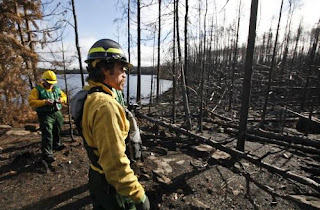
Carl Skustad of the U.S. Forest Service surveyed the fire damage near campsite 7 on Lake Three, charred by the Pagami Creek fire. in the BWCA. (photo by David Joles)

based partly on a news article in the Star Tribune

U.S. Forest Service officials took members of the news media on a paddling tour through the Boundary Waters Canoe Area Wilderness last Wednesday, to show them the effects of the Pagami Creek Fire. The burn pattern is called a mosaic, with some places charred and others not.

While the fire is comparable in size to the Ham Lake Fire of 2007, this fire did not burn across the North Country Trail. However, it did close the Kekekabic portion of the NCT because of the close proximity. The Kek is now open again.

The Pagami Creek fire burned across 51 BWCAW campsites, but only 5 are damaged enough that they are expected to be closed next year. Forest Service personnel will go through and cut down snags (leaning trees) which are a major danger after fires. Come spring, new growth will begin covering the black earth.

Over 1000 firefighters worked on the Pagami Creek fire, which is not yet quite 100% contained. The Pagami Creek fire area covered about 145 square miles, about 9.2 % of the entire BWCA. It burned down one structure -- a remote Minnesota DNR cabin.

This segment is in the Kekekabic Trail Guide
See Kekekabic Trail

Thursday, September 15, 2011

Kekakabic Trail Closed Due to Pagami Fire


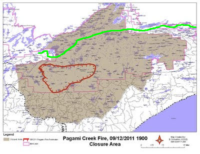
Pagami Fire Closure Area
fire closure area 9/12

from various sources

The Kekeabic Trail has now been closed, as has a large portion of the Boundary Waters Canoe Area Wilderness. For a much larger map with more detail, see the Closure Area Map from the Minnesota Incident Command. This is a pdf.

In the map above, the red outline is the fire perimeter as of Monday evening. The shaded area is the portion of the BWCAW that is closed. The green line is the NCT/Kekekabic Trail.


Wednesday, September 14, 2011

Pagami Fire Update


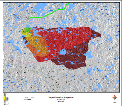
Pagami Creek Fire Map
Pagami Creek fire and NCT (green line)

compiled from various sources

The Pagami Creek Fire has now become larger than the Ham Lake Fire of 2007, but does not appear to be threatening the North Country Trail. The closest the fire approached the NCT was just south of Snowbank Lake near the western end of the Kekekabic Trail, with about two miles of forest between.

At this time, the fire is still spreading to the east. Early on, firebreaks were created to the north and these have held. The fire slowed today with light rain and higher humidity, but it has now reached blowndown timber from the 1999 event, and no one expects this fire will be out for a long time.

Command is now unified under Lake County, Superior National Forest, and Minnesota Incident Command. In addition to four Blackhawk helicopters sent by the National Guard, the province of Manitoba is sending two water bombers and an air attack plane.

Pagami Creek Fire Map
Pagami Creek fire and NCT (green line)

For the most current information, see the Minnesota Incident Command

Tuesday, September 13, 2011

Pagami Creek Fire Burning South of the Kekekabic


Pagami Creek Fire
smoke from Pagami Creek Fire (photo from a video at NorthlandNewsCenter.com)

compiled from various sources

The Pagami Creek Fire, in Minnesota, just east of Ely, is still south of the North Country Trail, but is still growing. The fire began on Aug 18, the result of a lightning strike. It was considered a minor blaze until two days ago when high winds suddenly spread the fire 16 miles to the east, to the edge of Polly Lake.

Most of the Boundary Waters Canoe Area Wilderness remains open, but many access points have been closed. Smoke from the fire has been seen as far east as Illinois, and is affecting air quality. The Pow Wow Trail is closed.

As of this afternoon, the fire has now burned 100,000 acres, and is second only to the Ham Lake Fire of 2007, which burned 120,000 acres, and is considered the most costly fire in Minnesota history. It has been difficult to determine the exact size of this fire area, because of the heavy smoke.

The fire has now spread so quickly that it is threatening to ignite areas which were affected by the 1999 Blowdown where stacked dry wood is like a tinderbox waiting to be lit.

Control of the blaze has now been delegated to a unified command with Lake County Sheriff's Office as full partners of management of the fire. The Governor has called in the Minnesota National Guard and helicopter support. A Red Cross aide station has been established at the Finland Community Center. Finland is a town on the Superior Hiking Trail.

The last map I could find showed this trail still miles south of Snowbank and Parent Lake where the NCT comes out of the woods on to Fernberg Road. But this is definitely one to watch. Earlier today an official incident map was available on line, but now that link seems to have been taken down. I'll add it here if it is put back.


See Kekekabic Trail Club

Saturday, April 10, 2010

Minnesota Campers- Note Fire Restrictions!

fire alert
from Web Clipart

OutdoorBlips: vote it up!
if you like this article, click the Blip chiclet!
a news release of the Minnesota DNR

open burning restrictions to begin April 12

Due to an increased concern about wildfires across the state, the Minnesota Department of Natural Resources (DNR) is tightening restrictions on campfires in 37 Minnesota counties beginning at 12:01 a.m. on April 12.

Counties affected by the new restrictions are: Aitkin, Anoka, Becker, Beltrami, Benton, Carlton, Cass, Chisago, Clearwater, Cook, Crow Wing, Douglas, Grant, Hubbard, Isanti, Itasca, Kanabec, Kittson, Koochiching, Lake, Lake of the Woods, Mahnomen, Marshall, Mille Lacs, Morrison, Otter Tail, Pennington, Pine, Polk (that portion east of County Highway 6 and south of State Highway 92), Pope, Roseau, Sherburne, Stearns, Stevens, St. Louis, Todd, and Wadena.

Campfires will not be allowed at non-designated campsites and other remote locations. This will impact shore lunches, dispersed campsites, day hikes, and backpacking trips.

Campfires are still permitted in designated fire receptacles at residences, dwellings, campgrounds, and resorts if they are no larger than 3 feet in diameter and 3 feet in height.

In addition, fireworks will be prohibited outside municipalities due to the volatile nature of these explosives.

Similar restrictions will be in place on national forest lands in both the Chippewa and Superior National forests including the entire Boundary Waters Canoe Area Wilderness.

Lack of rain after the rapid spring snowmelt has heightened fire danger across much of Minnesota. The restrictions will remain in place until sufficient precipitation is received to moderate fire danger. If normal precipitation is not received in the near future, additional restrictions may be imposed.

See Minnesota fire danger ratings