Notice: I've taken a part-time job, and it's definitely affecting my blogging time. I'll continue to add content here as often as possible. Pertinent guest posts are always welcome.

-
Showing posts with label trail closure. Show all posts

Thursday, September 15, 2011

Kekakabic Trail Closed Due to Pagami Fire


Pagami Fire Closure Area
fire closure area 9/12

from various sources

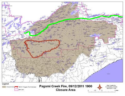
The Kekeabic Trail has now been closed, as has a large portion of the Boundary Waters Canoe Area Wilderness. For a much larger map with more detail, see the Closure Area Map from the Minnesota Incident Command. This is a pdf.

In the map above, the red outline is the fire perimeter as of Monday evening. The shaded area is the portion of the BWCAW that is closed. The green line is the NCT/Kekekabic Trail.


Sunday, July 3, 2011

Minnesota State Park Crisis

alt text
Gooseberry Falls State Park (photo by jhy

from various sources

All Minnesota State Parks are closed until the state budget crisis is resolved. This affects the North Country Trail primarily along the north shore of Lake Superior, and the Superior Hiking Trail section.

State Parks along the route include Jay Cooke (at the MN-WI border), Gooseberry Falls, Split Rock Lighthouse, Tettegouche, Crosby-Manitou, Temperance River, Cascade River, and Judge Magney.

Shuttle operator, Harriet Quarles, reports that all gates are closed and water is turned off. Thru-hikers should be able to move through the park on the trail, but no services are available.

The NCT does pass through one other Minnesota SP on the west side of the state, which is Maplewood.

There is no way to predict how long it will take Minnesota to resolve their $5 million gap between proposals of the two political parties. Minnesota Public Radio estimates that park revenue lost on the holiday weekend could be as much as $12 million.

Most segments are on SHTA maps

See Superior Hiking Trail
Wednesday, July 28, 2010

Kalamazoo River Oil Spill Closes Section of NCT

oil on kalamazoo river
floatingoil and boom on the Kalamazoo River near Historic Bridge Park (photo by Tom Garnett)

OutdoorBlips: vote it up!
if you like this article, click the Blip chiclet!
based on a news article at the Battle Creek Enquirer

Historic Bridge Park in Battle Creek has been closed until further notice as crews endeavor to remove the oil spilled from a pipeline which broke and entered Tallmadge Creek. From there it has flowed to the Kalamazoo River. Valves were quickly closed to stop the leak, but as much as 800,000 gallons of oil have entered the waterways. Work to clean and contain the spill began immediately.

The North Country Trail traverses Historic Bridge Park, and thru-hikers should note that they will need to detour around the park on 9 1/2 Mile Road.

This segment is on NCTA map MI-02

See Chief Noonday Chapter of the NCTA

Thursday, April 22, 2010

Kekekabic Trail Closed- Fire Danger

hikers on burned trail
trail area burned by Ham Lake fire in 2007(photo by JHY)

OutdoorBlips: vote it up!
if you like this article, click the Blip chiclet!
a news release of Superior National Forest

Beginning Friday, April 23, 2010, the Forest Service will close the entire Kekekabic Trail on the Superior National Forest to public use. The closure begins at Snowbank Lake Road: includes Wilderness Entry Point 74, Snowbank Lake Trail, Disappointment Lake Trail and all other associated connector trails and loops, Entry Point 56: and ends at Gunflint Trail County Road 12.

Superior National Forest managers are taking this step in response to the very high fire danger in northern Minnesota. The concern is that hikers could potentially become trapped if a wildfire starts and spreads in remaining blowdown fuels in the interior of the Boundary Waters Canoe Area Wilderness.

The Kekekabic Trail will remain closed until further notice.

This closure is in addition to a Forest-wide prohibition on the use of any campfires, charcoal or wood-burning campstoves on any national forest lands within the Superior National Forest. State and local government have enacted similar restrictions on other lands in northern Minnesota.

For additional information call 218-626-4300 or visit the Superior National Forest web site Superior National Forest or the Minnesota Incident Command System

Monday, September 14, 2009

NCT / Buckeye Trail Section Closed for a Month

rail trail Corwin Ohio
SR 73 bridge south of Corwin (photo from Little Miami Scenic Trail)

OutdoorBlips: vote it up!

based on a news article from the Dayton Daily News

A section of the paved Little Miami Scenic Trail in western Ohio will be closed starting today, Sept. 14, 2009, for approximately one month. Both hikers and bicyclists are being told to find an alternate route for the miles south of Corwin.

Corwin Road parallels the trail through the section and may be used as a detour. There will construction activity to be avoided, and precautions should be taken. Alan Ferguson, state park manager for the Cowan Lakes Region said, "We regret the inconvenience of a trail closure, however, it became apparent during our last site visit that due to the extent of the erosion and the size of the heavy equipment required to conduct the repairs, that a safe route around the project would not be possible."

Warren County Soil and Water Conservation District helped secure a grant from the Environmental Protection Agency to pay for repairs to the riverbank. The original railroad right of way forms the foundation of the trail, and needs to be stabilized.

The section in question is on the Caesar Creek Buckeye Trail map. Hikers have another alternative by taking the route through Caesar Creek State Park, which is probably preferable for hikers anyway. The foot trail here leaves the rail trail (going south to north) at Elbon Road, follows the shoreline of Caesar Creek Lake, and then returns to the rail-trail via Spring Valley Road.
Buckeye Trail Association