Notice: I've taken a part-time job, and it's definitely affecting my blogging time. I'll continue to add content here as often as possible. Pertinent guest posts are always welcome.

-
Showing posts with label Buckeye Trail. Show all posts

Thursday, October 6, 2011

New Bridge Near Napoleon, Ohio

bridge on Buckeye Trail
completed Buckeye/NCT bridge (photo by Bob Morrison)

based on a blog post of the Henry County Parks

With the dedication and enthusiasm of local volunteers, on July 23, 2011, the new bridge was opened on the Buckeye Trail/North Country Trail in northwest Ohio. This bridge is about a quarter-mile east of the Henry County Hospital near Napoleon.

With the completion of this bridge, the entire trail in Henry County is clear. Read more, and see more pictures at New Bridge Built on the Buckeye Trail / North Country Trail


This segment is on Buckeye map Defiance section

See Buckeye Trail


Wednesday, September 21, 2011

Attendee Report- Dayton Conference

Clifton Gorge
Clifton Gorge (photo by jhy)

by John Heiam, from the Sept 2011 issue of the Grand Traverse Hiking Club Newsletter

In August Dick Naperala, Rick Halbert, Arlen and Arlene Matson, and Lois Goldstein and I attended the 2011 North Country Trail conference in Dayton Ohio. As many of you know, the NCTA has a conference every August at a different location along the trail. This year it was in Dayton, Ohio. One of the things I enjoy about going to the conference is seeing the beauty that exists in unexpected areas. Two years ago the conference was in North Dakota, and I thought the area wouldn’t have much to offer.

I was really surprised by the beauty in the area. Much of North Dakota consists of rolling green hills, with areas of forest. This year I wondered what an urban area like Dayton could offer. One day we were led on a hike to Clifton Gorge, where a small stream has carved a channel through a hundred feet of rock. While I was at a Board meeting, Lois went on a kayak paddle along the Mad River. On another day, we were led on a thirty-five mile bike ride on a beautiful tree lined paved trail, topped off with a lunch stop at a local restaurant that made its own ice cream.

In Xenia, Ohio just south of Dayton, four long paved bike trails intersect. Downtown Dayton has been transformed from an industrial center to a city laced with parks and an absolutely beautiful river front. One night after the conference presentation by Andrew Skurka, we listened to a free open air concert of a local big band, playing music from the forties and fifties. They played in an ultra-modern open air pavilion along the river. Next to the pavilion is a new bicycling hub, which includes a new building with showers and a bicycle storage area for people who want to commute downtown by bicycle.

The number of paved bicycle trails in the area is astounding.


This segment is on Buckeye Trail map Caesar Creek

See Buckeye Trail


Saturday, June 11, 2011

Sign Up to Build Trail in Ohio

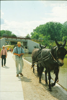
canal boat ride at Grand Rapids Ohio
restored canal at Providence Metropark (photo by jhy)

from Rick Adamson Ohio State Trail Coordinator

Sign up to help build trail in northwest Ohio between the communities of Florida and Grand Rapids in Henry and Wood Counties.

Rick Adamson's renowned work crew will build new off-road trail on the historic Miami & Erie Canal towpath route. Accommodations are camping at Mary Jane Thurston State Park (no electric hookups).

Some food is being provided by the St. Patrick's Catholic Church, but for most meals volunteers must provide their own.

The event runs between Saturday, June 18 and Wednesday, June 22. Work times are generally from 8 am to 3 pm leaving plenty of time for recreation.

The North Country Trail currently breaks off from the Buckeye Trail in this section and heads north through Liberty Center. Come see why the trail should continue to Grand Rapids before turning north! At Providence Metropark you can experience the canal days with a ride on a recreated canal boat, and a visit to the operating Ludwig Mill.

Contact Rick Adamson for more details.

This segment is on BTA Map Defiance Section

See the Buckeye Trail

Wednesday, May 26, 2010

Buckeye Trail Work Week Signup


from Rick Adamson

The Ohio State Trail Coordinator for the Buckeye Trail/ NCT announces a work week on the Miami and Erie Canal towpath, June 2-6, 2010.

This will continue the project of connecting off-road trail from Defiance to Grand Rapids, Ohio. Camping will at Mary Jane Thurston State Park, and food and refreshments should be provided by participants, with the exception of Wednesday when dinner will be hosted by Joe & Cindy Krueger.

Tools and training are provided free of charge by Jim Runk, and Assistant State Trail Coordinator. Certified first aid persons are part of the volunteer staff.

Rick

P.S. from JHY- I have personally participated in one of Rick's work weeks on this section. They are very well organized, and you will finish the week feeling very satisfied that you have been a part of the team, and important to the accomplishments, no matter what your skill level.

This segment is on BTA Map Defiance Section

See Buckeye Trail

Tuesday, November 24, 2009

Tar Hollow - Ohio Spotlight

tar hollow state forest sign
(photo by JHY)


OutdoorBlips: vote it up!
if you like this article, click the Blip chiclet!
based on a news release of the Akron Beacon Journal

Tar Hollow State Forest in south-central Ohio is often overlooked in favor of the better known Old Man's Cave or Hocking Hills. Tar Hollow State Park is just 619 acres within the 16,000 acre state forest. But this very natural park offers plenty of what Ohio used to be like before it was heavily settled.

The area is known for steep ridges and deep ravines. On the dry ridge tops one can find oaks, hickories, shortleaf and pitch pines. Along the rivers the black willow, sycamores, and buckeyes abound. The area is located in the sandstone hills that transition to the Allegheny Plateau.

tar hollow fire tower
Brush Ridge fire tower (photo by JHY)
The forest was named for the tar from the pitch pines. It was a staple for early settlers who used it for everything from liniment to lubricant. It was also distilled into turpentine.

The forest has an extensive trail system roughly in a figure 8. At the center of the system is the Brush Ridge Fire Tower. The Buckeye / North Country Trail reaches this point from the SE, and then makes a sharp turn at the tower to the SW.

One could easily spend a long weekend at Tar Hollow. In all, there are 24 miles of hiking trails, and 2.5 miles of mountain bike trails. There are five backpacking campsites and seven overnight log shelters. 25 miles of bridle trails also traverse the forest, including a horse camp.

Wildflower enthusiasts will find southern Ohio to be spectacular in the springtime.

tar hollow fire tower
violet wood sorrel (photo by JHY)


The Tar Hollow Region stretches from points 2 to 7 on the Scioto Section of the Buckeye Trail Maps, for 11.7 miles of off-road trail. Camping is allowed near the fire tower (no water).

The Beacon Journal article gives much more information about the local area.

See Buckeye Trail
See Tar Hollow State Forest


Saturday, July 4, 2009

Couple Backpacking the Buckeye Trail

Peter & Joyce Cottrell
Peter & Joyce Cottrell (photo by Faye McNabb)
based on a news article in the Evening Leader, "Couple Hikes Trail," by Katie Yantis, June 19, 2009

Beginning at the small town of Richmondale this spring in southern Ohio, experienced hikers Peter and Joyce Cottrell plan to return there in September 2009. In 2003 the Cottrells were the first people to backpack the American Discovery Trail. The ADT is concurrent with the Buckeye Trail across southern Ohio. The North Country Trail also follows about 800 of the 1400 miles of the 1400-mile Buckeye Trail loop.

On June 19, the Cottrells reached St. Marys in northwest Ohio. The Heritage Park Trails District Director Allison Brady, who has hiked the Appalachian Trail, said she recognized what the Cottrells were doing. She offered them some help and a day without their 45 pound and 30 pound backpacks. She also bought them dinner and offered a place to spend the night. The kindness of people they meet never ceases to surprise the couple.

The Cottrells said they have enjoyed about Ohio, especially the local people. “I am really loving the birds,” Joyce Cottrell said. “We are really loving the people.” She really enjoyed sharing their story with a group of ladies in a coffee shop in Bremen.

“We get simple pleasures out of the Buckeye Trail,” Joyce Cottrell said. “This is all we do, we live a very simple life, and we are trying to make people understand you can do anything you want to do.”

See the Cottrell's story on the American Discovery Trail
See The Buckeye Trail

Thursday, April 30, 2009

Buckeye Trail Celebrates 50th Anniversary This Year

map of the Buckeye Trail
based on a news release in the Columbus Dispatch, "Buckeye Trail cuts circular path through amazing diversity of Ohio"< by Steve Stephens, April 26, 2009

No matter where you go in Ohio you are likely to run into the Buckeye Trail's blue blazes.

The longest single-state loop trail in the US, the Buckeye Trail is 1440 miles long. The NCT is concurrent with it for about 800 of those miles. "The trail follows dedicated gravel or dirt hiking paths, old canal towpaths or railroad rights of way, county roads and even a few city sidewalks. It cuts through vast forests, skirts industrial land and farm fields, passes museums and historical sites, descends into beautiful, steep valleys and traverses seemingly unending plains."

Gary Williams, board member of the Buckeye Trail Association, explained that there is very little public land in Ohio. But where the trail follows roads, the route is chosen to find roads that are very little used. "Sometimes, you can hike on these roads all day and never see a car, " Williams commented.

This year is the 50th Anniversary of the trail, and in addition to the many hikes that are planned, there will be a special celebration June 12-14 at Camp McPherson near Danville.

About 100 people have hiked the entire loop. One weekend a month there is a hike that works at the continuous loop, so that dedicated participants can complete the entire trail, given enough time.

To kick off the 50th anniversary of the trail, the Buckeye Trail Association will hold a special celebration May 16 at the Grandma Gatewood trail section in Hocking Hills. in the Hocking Hills. "Grandma" Emma Gatewood, at age 67, in 1955, became the first woman to hike the entire Appalachian Trail.

Gatewood became one of the primary supporters of the Buckeye Trail project and reportedly donated the money to buy the first few pails of blue blaze paint, used on the trail through the Old Man's Cave area. The May 16 adventure will begin at 10 a.m. with a ribbon-cutting and a 6-mile round-trip commemorative hike.

See Buckeye Trail Association

Tuesday, April 28, 2009

Buckeye Work Party to Continue Towpath Recovery

trail crew cutting trail
working on the Miami-Erie towpath trail in 2003 (photo by JHY)
submitted by Rick Adamson, BTA Trail Coordinator

The Buckeye Trail / North Country Trail towpath section east of Defiance, Ohio, will be the site of another multi-day work session, May 5-9.

Several years ago the Ohio DNR decided to take advantage of the fact that they still owned the right-of-way for the 150-year-old Miami-Erie Canal. In a number of places where the route had not been overcome by trees or plowed under by farmers the BT/NCT was already using this pathway. But the DNR determined that there were another 47 miles of off-road trail that could be added to the system, and they decided to act on this.

So for several years, the Buckeye Trail has been hosting work crews to recover these miles of towpath which are often completely overgrown. For this work party, camping will be at Mary Jane Thurston State Park. There are fire rings and flush toilets.

Work will begin at 8 am each morning and conclude at 3 pm most days and noon on Saturday, the final day. Participants need to provide their own food and water.

There are all levels of work and trail building abilities needed. If you are interested in weed which will leave you with a sense of real accomplishment, contact Rick and sign up to help.

Contact Rick Adamson

See Buckeye Trail Association

Tuesday, March 31, 2009

Pettisville Ohio Students Help Spring Clean Buckeye / NC Trails

based on a news article in the Toledo Blade, "Pettisville local schools students take shine to history," by Janet Romaker, Mar 31, 2009

Each year students from Pettisville, Ohio schools spend a day doing service projects. Most of the effort goes to the historic Sauder Village in Archbold, Fulton County, in the northwest corner of Ohio. But just south of their county the concurrent Buckeye and North Country Trails come from the south to Defiance and take a sharp turn to the east on the towpath of the former Miami-Erie Canal.

Students asked if there was anything they could do to help the trail. The Buckeye folks recalled the good job that Pettisville students did two years ago and organized the group of 80 young people to clear portions of the towpath between Napoleon and Grand Rapids. "The previous work ethic of the students opened up the Buckeye Trail opportunity for us this year. We talked about that with the kids, the reason why that happened," teacher Mr. Reid said.

"As students see results of their hard work, "it gives them a sense of accomplishment and they are still learning," he added.

See Buckeye Trail Association

Friday, February 20, 2009

Buckeye Trail to Celebrate 50th Anniversary

Buckeye Trail logo

from the Buckeye Trail Association

BTA 50th Anniversary Annual Meeting - Camp McPherson

Make plans now to attend the 50th Buckeye Trail Annual Meeting from June 12-14. This celebration will prove to be a once in a lifetime event you won’t want to miss. This year’s Annual Meeting will continue all the traditions you associate with Annual Meetings—the hikes, the programs, the camaraderie. But the special celebration associated with our 50th birthday means that there will be several added and unique features.

For one thing, this year’s conference has been moved to June 12-14, so there will be no worries about Ohio’s sneaky April snows. And the venue has been changed to a centrally located site so that folks from all across the state can attend easily. The BTA has booked Camp McPherson near Danville to host this special celebration. Camp McPherson is a full service site that offers a wide range of accommodations. In addition to camping and dorm style facilities, there are also a limited number of motel type rooms available.

Even the menus have been carefully selected for your dining pleasure. An added feature is a band that has been added for a Saturday night barn dance. The annual business meeting has been moved to Sunday to provide you with a more active Saturday program of speakers, hikes and special events. And while the site is not along the BT, it is conveniently near the Mohican region that offers ample opportunity for short and long hikes as well as canoeing.

There are many special events planned in a year long celebration of the 50th birthday of the BTA. But the biggest of all will be the Annual Meeting from June 12-14 at Camp McPherson near Danville. The schedule and registration forms are available on the annual meeting page, but be sure to save the date and book now to get your choice of accommodations for this very special celebration.

Registration: 4:00 p.m. at Camp McPherson on Friday. The annual business meeting will take place at 9:00 a.m. on Sunday the 14th.

For nearly 1444 miles, the Buckeye Trail winds around Ohio, reaching into every corner of the state. From a beachhead on Lake Erie near Cleveland, to an hilltop overlooking the Ohio River in Cincinnati, a hiker can experience a little or all that Ohio has to offer.

First envisioned in the late 1950’s as a trail from the Ohio River to Lake Erie, the Buckeye Trail evolved into a large loop, branching both north and east from Cincinnati. The separate legs rejoin in the Cuyahoga Valley National Park near Cleveland, and complete the trip to the lake. Because it is a loop, it is also in essence, endless. You may start a hike at any point and hike as long as you want without ever reaching an end!

The North Country Trail is concurrent with the Buckeye Trail for approximately 800 miles.

See Buckeye Trail Association

Friday, January 23, 2009

What is Landscape- an Ohio Essay

excerpts from the blog Tales of a Bad “Geographer”, "So I'm Procrastinating, Dec 11, 2008, by Luke Badgerow, used with permission

What is Landscape?

I prefer to begin my stories in the middle, this way it gives me latitude to meander forward in the story through the “exciting parts” and fill in what details I need as I need them.

Not Sending weather, but ICE weather
I start with a photo of an element, or portion of a landscape. Not because the photo is the landscape, or that it contains the definitional element that I associate with what a landscape is. But more because of the fact that the image, and its relation to a number of others describes an ordering of reality from different angles.

This particular picture is of my dog, who has been a constant companion on nearly every outing I’ve made in the last six years, but more importantly this image is of the landscape, in the broader, vertical view, of a considerable portion of Southeast Ohio. The specific element or locale here is twenty feet off of the main trail, part of the Buckeye Trail that circumvents [sic] the entire state, but all the same many people don’t venture away from the cliff band and look out over this gully.

In March with four inches of snow and a veneer of veriglass ice on all rock surfaces, the hike to my perch takes around half an hour. In early December before the winter truly reaches into this hollow, the hike takes ten minutes. So time has played an important factor in the definition. Every place, every subject changes as time passes. This is as true for this particular place in the Hocking State Forest as it is for Lower Manhattan.

Not Sending weather, but ICE weather
I draw attention to my perch one more time, only this time I take it from the valley /hollow floor on a day in April of last year as winter finally let go of its hold, but before spring gets complete control, to demonstrate a quick final point about the concept of defining landscape. I make this argument from a particular perspective or perception, but that perception changes, as does the weather, as the fog lifts from the valley floor, you still can’t see my spot… So who’s to say that it’s an actual place, or some fabrication of my mind? But at the same time, what difference does it make?

See So, I'm Procrastinating to read the entire, complex essay on Landscape.

Thursday, January 8, 2009

I Am a National Park Service Voluteer

Deven D Atkinson
Deven D Atkinson
from the blog Blogtide Rising,by Deven D Atkinson, Nov 28, 2008, used with permission

This week, quite by surprise, I found out that I have been recognized by the National Park Service as a 100 hour volunteer. They sent me a certificate of appreciation (suitable for framing), an National Park Service Volunteer lapel pin (very high quality craftsmanship), and a North Country National Scenic Trail 100 Hours of Volunteer Service engraved name badge (with my name spelled correctly!!!).

You would have though that I would know that I was a National Park Service Volunteer, and that I would not have been surprised. After all, how would a person donate 100 hours of service and not know it?

The answer is quite simple. I am also a 100 hour volunteer with the Buckeye Trail Association. They gave me a nice embroidered blue flannel shirt early this spring as thanks for my service. All of my BTA volunteer work has been with the Trail Crew in southern Ohio and with the Buckeye Trail segment that my Dad and I maintain. All of this trail is actually three trails that share the same footpath: The Buckeye Trail, the American Discovery Trail, and the North Country National Scenic Trail. Every hour I volunteer is an hour volunteered for each. I knew that the North Country trail was sponsored by the National Park service, but I did not realize that it was actually recognized as part of the National Park Service. Now I know, and I have a very nice lapel pin to prove it. And if I can ever figure out when and where the Adams County chapter of the North Country Trail Association meets, I can wear my name badge and have instant credibility.

Now that I am the BTA Scioto Trail section supervisor, my National Park Service volunteer hours are going to climb very fast!

Friday, December 19, 2008

Buckeye Trail / NCT Makes Robin Smile

Buckeye Trail


from the blogs Bogs of Ohio and Bountiful Healing by Robin. Various entries, used with permission


10 things that make me smile

#1: Walks and hikes in the woods

Buckeye Trail

Buckeye Trail
"The clearest way into the Universe is through a forest wilderness." ~ John Muir

We woke up to a clear, cold day, the sun shining like crazy. The temperature was 20 degrees (F). M and I decided to take a hike on the small piece of the Buckeye Trail near where we live.

This is my favorite kind of hiking weather. I love how blue the sky looks in the winter, and how crisp and fresh the air feels and smells.

It was a good way to start out the month of December, before things get messy (as they will tonight with a snow, sleet, and rain mix).