Notice: I've taken a part-time job, and it's definitely affecting my blogging time. I'll continue to add content here as often as possible. Pertinent guest posts are always welcome.

-
Showing posts with label trail building. Show all posts

Monday, December 5, 2011

Three New Bridges in Newaygo County, MI

One Year, Three Bridges from Paul Haan on Vimeo.


from the Western Michigan Chapter of the NCTA

The bridges span Bear Creek, Rattlesnake Creek and Second Cole Creek. Great accomplishment!


This segment is on NCTA map MI-04

See Western Michigan Chapter of the NCTA


Tuesday, October 4, 2011

Ferrying Materials for Wisconsin Puncheon

lumber carried on canoes
canoe ferrying construction material (photo by Bill Menke)

excerpted from NCTA blog by Bill Menke

We had a very productive (but also very strenuous) outing last week. For several years we puzzled over how to get our puncheon materials into the trail segment that is on the north side of the St. Croix River and between the Gordon Dam ATV Trail and West Mail Road (map), Because of the flat rocks that we used to construct a walking surface on the upland portions, our powerwagon would have bounced around and literally destroyed the work we had already done while we were waiting for the WI-DNR to issue the permits we needed to construct the wetland structures.

We considered a helicopter contract (too expensive at a minimum $100,000), and draft horses, snowmobiles, and ATVs dragging or trailering the materials through the woods. All of these latter three modes would have also destroyed the trail. We also thought about boating the materials down the river from Gordon Dam but there are too many shallow places which would prevent passage with a loaded boat.

Finally, crew member Phil Anderson came up with the idea of working them across the river with two canoes that were fastened together to form a carrying platform.

This was a tremendous transportation job. All in all, we moved over 100 4x6x16 foot beams, 100 telephone pole sills (5 feet long), and almost 1900 deck boards (3 feet long) across the river. All that is left of the south side for next month is about 15 sills and 15 beams and these are all already at the river edge or at the top of the bluff.

For lots more pictures and more explanation see the NCTA blog- link below.

This segment is on NCTA map WI-02

See Rover’s unique puncheon material canoe ferry operation


Tuesday, September 27, 2011

Wetmore Pond Eagle Scout Project


scout troop
Scouts, leader, and Cliff Stammer after a day of work. (photo from NCTH)

from the North Country Trail Hikers Footprints, Fall 2011

In July, Andrew Virch, working towards an Eagle Scout Badge, organized a work crew of scouts and leaders from Troop 309, along with several of our members, to replace and build some puncheon board walk in Wetmore Pond. In a day and a half of work, the project was complete.

puncheon
Completed puncheon in Wetmore Pond (photo from NCTH)

This segment is on NCTA map MI-12
See North Country Trail Hikers Chapter of the NCTA


Saturday, June 18, 2011

AmeriCorps Trail Work Near Marquette

benching trail at Silver Lake
benching trail at Silver Lake (photo from NCT Hikers)

from Footnotes, summer 2011

On Sunday, June 5, a group of 17 AmeriCorps volunteers from the Greater Grand Rapids Area American Red Cross arrived in Marquette to help with a variety of projects on the trail. Monday morning three different groups went to work.

One group worked Monday through Thursday, at the McCormick Wilderness segment and into Segment 25 where they cleared a slew (over 65) of blowdowns, lopped and raked the trail. Remember that no power tools are allowed in the Wilderness, so all their efforts were executed with hand tools - crosscut saws, loppers and rakes.

A second group met in Ishpeming and headed north to build new trail on the west side of the Mulligan Plains up a steep hill. A series of switchbacks were built including sections of benching the trail and adding rock steps. Four full days of physical exertion added slightly less than a mile of new blue-blazed trail up the hill for a rise of over 330 feet in elevation.

trail puncheon
new puncheon at Wetmore Pond (photo from UpperMichigansSource.com)
The third group headed out to Sigan Road in Alger County to do some heavy lopping, general trail maintenance and blazing. Just getting in and out of that work site via Sigan Road from Sand River Road was an adventure the AmeriCorps probably won’t forget for a while. This group also worked at Wetmore Pond, removing the old boardwalks and replacing them with all new materials on the Old Growth Trail. A couple of reroutes and shorter boardwalks were also tackled on the west trail. Swamping through the muck paid off when the completed project could be easily hiked without fear of falling through a broken board. Note that Plum Creek Timber Company donated all building materials for the Wetmore Pond project. A subgroup also repaired handrails, added a step to some stairs and did a small reroute on the Wetmore Landing segment on the east side of County Rd 550.

This segment is on NCTA map MI-12

See North Country Trail Hikers Chapter of the NCTA

Saturday, June 11, 2011

Sign Up to Build Trail in Ohio

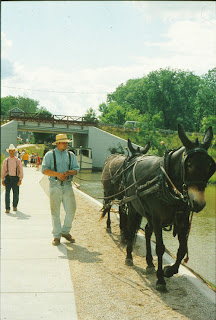
canal boat ride at Grand Rapids Ohio
restored canal at Providence Metropark (photo by jhy)

from Rick Adamson Ohio State Trail Coordinator

Sign up to help build trail in northwest Ohio between the communities of Florida and Grand Rapids in Henry and Wood Counties.

Rick Adamson's renowned work crew will build new off-road trail on the historic Miami & Erie Canal towpath route. Accommodations are camping at Mary Jane Thurston State Park (no electric hookups).

Some food is being provided by the St. Patrick's Catholic Church, but for most meals volunteers must provide their own.

The event runs between Saturday, June 18 and Wednesday, June 22. Work times are generally from 8 am to 3 pm leaving plenty of time for recreation.

The North Country Trail currently breaks off from the Buckeye Trail in this section and heads north through Liberty Center. Come see why the trail should continue to Grand Rapids before turning north! At Providence Metropark you can experience the canal days with a ride on a recreated canal boat, and a visit to the operating Ludwig Mill.

Contact Rick Adamson for more details.

This segment is on BTA Map Defiance Section

See the Buckeye Trail

Saturday, October 30, 2010

Backing Needed for New Wisconsin DNR Trail Rule

trail leading to WI DNR office
a trail leading to the Wisconsin DNR South Central Headquarters (photo by Todd McMahon)

submitted by Todd McMahon

A new Wisconsin Department of Natural Resourses Rule aimed at speeding up development of the North Country Trail and Ice Age Trail will have a public hearing on November 3, 2010 in Fitchburg, Wisconsin.

The rule allows the trails to be built before the Master Plan for a property is developed. It can take 6 to 10 years for a Master Plan to be developed for properties purchase by the Wisconsin DNR. The new rule applies to lands specifically purchased for trail development. Currently, there are over 70 such properties awaiting a Master Plan including the recently purchased Nemjadi River Tract and Stilin Property Tract for the North Country Trail.

According to an email sent by Kevin Thusius of the Ice Age Trail Alliance, the new rules “will make it possible to start new Trail Construction…immediately upon acquisition.” And according to a DNR Correspondence by Matt Frank, “These rules would provide property managers guidance for pre-Master Plan management of lands purchased for the Ice Age and North Country trails.”

The Public Hearing will be held at 6 pm, Wednesday, November 3, 2010 at the DNR South Central Region Headquarters, 3911 Fish Hatchery Road, Fitchburg, Wisconsin. Written comments on the proposed rule may be submitted via U.S. mail to:
Ms. Brigit Brown
Bureau of Parks and Recreation
P.O. Box 7921
Madison, WI 53707.
Comments may be submitted by email to brigit.brown@wisconsin.gov.

Comments on the proposed rule must be received on or before November 5, 2010.

This segment is on NCTA maps WI-01-03

See Wisconsin DNR Proposed Rule Page for more information

Thursday, September 2, 2010

Connection to GET Progressing via Crystal Hills Branch

connection of Great Easter Trail to Finger Lakes Trail
from fingerlakestrail.org

info from the Finger Lakes Trail Conference

The North Country Trail will soon be connected to the Great Eastern Trail (GET). The GET roughly parallels the Appalachian Trail, but on the west side of the mountains. In Pennsylvania the GET follows the Mid-State Trail to the New York border. At that point there are about 6 miles of road walk in Steuben County's Town of Tuscarora. At that point the trail enters Pinnacle State Park. Next, the trail passes through McCarthy State Forest and reaches the Village of Addison at a small cemetery. It will ultimately join the Finger Lakes/ North Country Trails. Orange blazes mark the route of the GET.
portion of Crystal Hills map
from fingerlakestrail.org


A new section of the Crystal Hills Trail is now open which continues the route from Addison. The new trail is on map CH2 and starts from where the blazing previously stopped at the corner of Maple St. and Ames St in Addison. Hike north from there through cemetery, tree farm, and woods. You come out of the woods on Mose Rd., just west of Beeman Hollow Rd. The new section is 4.0 miles long. There are also two new short spur trails, one to a waterfall and the other down to parking on NY 417. Not only is this a pretty section of trail to hike, but it eliminates the roadwalk along busy NY 417.

This segment is on FLTC map CH 2

See Finger Lakes Trail
See Great Eastern Trail Moving Closer to Connection with NCT/FLT

Sunday, August 29, 2010

Partnership Creates Premier Experience

worker drilling holes for boardwalk
Jim Heaton of Kalamazoo prepares understructure for boardwalk

by JHY

Sterling Marsh? Where the heck is that? Well, thanks to the partnership efforts of the North Country Trail Association (NCTA), National Forest Service (NFS) and National Park Service (NPS), Sterling Marsh should soon become a popular local wildlife watching destination.

Located in Lake County, Michigan, along the course of the North Country Trail, Sterling Marsh has historically been anything but a popular destination. In fact, it’s been one of the more dreaded sections of NCT in Michigan. Sometimes knee-deep in water in spring, and seriously muddy at most any time of year, thru-hikers sighed and slogged through while day-hikers simply avoided the place.

Yet, for the brave, the area is rich in wildlife. Birds enjoy the open water portion of the marsh. Local frog census taker for the state, Vicky Kelly of Baldwin, visits there regularly as a locale on her counting route. She and partner, John Cooley, are also the volunteers who regularly maintain that section of trail. “It can be pretty tough to get through in the spring,” Vicky commented. But that is changing.

muddy area near boardwalk
note old trail and too-low bridge beside new boardwalk- taken in April 2010
For two summers, the Spirit of the Woods Chapter (SPW) of the NCTA has been making a lot of noise in the woods between Jenks Road and 96th St south of the 76th St. trailhead. They are nearing the end of year two of a three-year project to get the Sterling Marsh trail out of the mud by building a raised boardwalk through the area. When complete, there will be over a half-mile of dry wooden walkway. Following a recent group effort by volunteers, over 1700 feet are already complete.

The project is a perfect example of how partnerships create better trails. The NPS is the managing authority for the trail, and in that capacity offers competitive matching funds for improvements to the North Country Trail. The match can be made in volunteer hours. Local groups, such as the chapter, are usually willing to work, but can’t possibly come up with the money to build large projects like this. The NFS comes into the picture because they manage this section of land within the Manistee National Forest. They had to approve building such a project, and in this case they have also supplied some of the materials. This is allowing the chapter to extend the boardwalk even farther than the original plan.

This past week, the chapter hosted a Volunteer Adventure week, organized by the NCTA. People signed up to come camp and work hard for a whole week. Their only reward was free food and seeing a job well done. Over 15 people showed up at various times from as far away as Kalamazoo, Holland and Stockbridge, MI. About half the volunteers were regulars from Spirit of the Woods. With the help of two portable generators to power the drills and saws, and a power wagon to aid in transporting the wood, the workers saw their product slowly snaking behind them through the trees– a lovely raised walkway.

people adding boardwalk decking
Peg Roth and Loren Bach add decking boards
A small deck has been added near the middle of the structure. The NFS has agreed that it makes perfect sense to make the approach to the north end accessible, and will fund construction of this detail. Thus, when complete, the entire boardwalk will be wheelchair friendly, a great addition to local trail opportunities.

SPW trail work coordinator, Ed Chappel of Irons, has overseen the huge project, and reports that thousands of volunteer hours have been invested so far, with more to come.

So, next time you are wondering where to find a piece of premier trail for a stoll, think Sterling Marsh. Happy birding... frogging... hiking!

This segment is on NCTA map MI-05

See Spirit of the Woods Chapter of the NCTA

Wednesday, May 26, 2010

Buckeye Trail Work Week Signup


from Rick Adamson

The Ohio State Trail Coordinator for the Buckeye Trail/ NCT announces a work week on the Miami and Erie Canal towpath, June 2-6, 2010.

This will continue the project of connecting off-road trail from Defiance to Grand Rapids, Ohio. Camping will at Mary Jane Thurston State Park, and food and refreshments should be provided by participants, with the exception of Wednesday when dinner will be hosted by Joe & Cindy Krueger.

Tools and training are provided free of charge by Jim Runk, and Assistant State Trail Coordinator. Certified first aid persons are part of the volunteer staff.

Rick

P.S. from JHY- I have personally participated in one of Rick's work weeks on this section. They are very well organized, and you will finish the week feeling very satisfied that you have been a part of the team, and important to the accomplishments, no matter what your skill level.

This segment is on BTA Map Defiance Section

See Buckeye Trail

Tuesday, January 19, 2010

No. 12/15 To No. 19 Road Reroute

bridge and steps
bridge (photo by Arlen Matsen)

OutdoorBlips: vote it up!
if you like this article, click the Blip chiclet!
from the Grand Traverse Hiking Club NCTA Chapter Newsletter, Dec 2009 used with permission

by Arlen Matsen

Phase 3 of last year’s Hodenpyl - NCT Reroute was completed on November 2. This new section of the NCT measures 4.7 miles from the corner of No.12 and 15 roads to its terminal point where it reconnects to the NCT at No.19 Road. There is parking at No.12/15 Road, and another lot adjacent to Harvey Bridge at No.19 Road.

This reroute was built from August to mid- November by our Trail Crew of 32 workers. It is our most rugged section of hiking trail and involves eleven stream crossings, and numerous steep ravines. Bridges are in place, water bars built, steps installed, trees blazed the familiar blue, and signage erected where necessary.

Never was there a section of trail built that involved so much benching into clay, while working through an unusually wet October. Heavy were our shoes as they became laden with Manistee River clay, but the views of the river, and the sound of rushing creeks in the ravines gave us an inspiring contact with a truly wilderness setting. On two occasions we brought an orange plastic sled from home to help carry decking to the bridge sites, while we used Ed’s wagon to do the same. The skillful use of 4x6’s, 2x4’s, 2x6’s, 6x6’s, nails, spikes, drills, Pulaskis, McCleods, bowsaws, loppers, levels, hammers, flagging, and miles of walking classify all of this crew as “Pros”.

trail steps
Sara's steps (photo by Arlen Matsen)
We secured two grants from the NCTA totaling $1306 to pay for some of the materials. The more we worked, the more needs we discovered, so another grant from the NPS for $286 was secured. The ravines and streams challenged us again for more funding. As we began to approach rifle deer hunting season, a 16-foot bridge needed to be built and adjacent 17 steps up the Big Ravine. Deena Barshney and Sara Cockrell came to the rescue and both wrote checks to cover the need of an additional $850. So, when you are out hiking the new NCT, about a mile from Harvey Bridge, you will discover two very special places. We call them Deena’s Bridge and Sara’s Steps, a most surprising legacy indeed; our crew and club are grateful.

An outstanding feature of this reroute is that there are at least 12 scenic vistas along the Manistee River. At the eastern end of this section of trail, where the new trail joins the existing NCT, coming from Wheeler Creek, there is a fantastic overlook which some of us believe exceeds even the Highbanks Rollway site. You may wind up with muddy boots, but the hike is worth it. And hopefully the trail is wide enough so you won’t be scratched by many of those thorn bushes (puckerbush) and hawthornes. True, there aren’t the flowers of the Hodenpyl area, but you can try to spot the unusual blue beech trees.
Manistee River
Manistee River (photo by Ed Morse)


On the subject of the Highbanks Rollway, the section of trail leading to it has been faithfully maintained for many years by Fred & Kathy Sabel and Larry & Donna Dodd. It has been included in their reports as a place needing restoration due to trashing and erosion. Dick Naperala, John Heiam and I will propose to the Cadillac DNR when we meet for our annual meeting that this site be given particular attention as a special place worth stabilizing and protecting.

This segment is on NCTA map MI-05

See Grand Traverse Hiking Club Chapter of the NCTA

Saturday, November 21, 2009

Trail Connected Chippewa to Itasca

Jerry Trout
Jerry Trout on new boardwalk (photo by JHY)

OutdoorBlips: vote it up!
if you like this article, click the Blip chiclet!
guest post by Jerry Trout

November 19, 2009 at 3:20PM is now a historical moment. The North Country Trail is now completed between the Chippewa National Forest and Itasca State Park.

We drove the symbolic golden spike four and six tenths miles east of Itasca State Park. Ray Vlasak and his Bad Medicine folks started the trail east from Itasca before they were diverted to the Laurentian Lakes Chapter. The Itasca Moraine Chapter built west from the Chip until Ray left and then we worked both ways.

Thursday was the culmination of the effort that began in earnest September 13, 2001. John Leinen brought up a crew on that date from the metro area and the Itasca Moraine Chapter was formed the next spring. The Federal Recreation Trail Program, Minnesota Conservation Corps, National Park Service, Hubbard County, NCTA, MN DNR can all share in this moment but the true champions in this effort are the following people:
  • Arlen Damlo
  • Carter Hedeen
  • Bruce Johnson
  • Darrin Miller
  • Darrel Rodekuhr
  • Harvey Tjader
  • Jerry Trout
  • Ray Vlasak

NCT kiosk at Itasca State Park
new North Country Trail kiosk at Itasca State Park southern entrance. Plaque commemorates Rod MacRae, Minnesota NCT trail pioneer. (photo by JHY)


As I keyed the above names I was overcome with emotion. This was an effort spanning eight years that overflowed with work, fun, vision, and passion

Regards, Jerry

See Itasca Moraine Chapter of the NCTA


Friday, October 23, 2009

NCT Hikers Volunteer Adventure Success

volunteers building trail
trail crews grubbing trail (photo from NCT Hikers Chapter)

OutdoorBlips: vote it up!
if you like this article, click the Blip chiclet!

from the Fall 2009 Newsletter of the North Country Trail Hikers Chapter of the NCTA

From Wednesday evening, September 16 through Tuesday morning, September 22, the Marquette, Michigan, North Country Trail Hikers Chapter hosted a NCTA Volunteer Adventure east of County Road 510 approximately 11 miles north of US-41/M-28. Primitive camping at the site was home for the week for 10 of the 24 participants.

Superb meals prepared by John Forslin and Sue Holtzmann were enjoyed by all. Jan Lindstrom Wester served as our Marquette based emergency contact person. Work building new trail took place on Thursday, Friday, Sunday and Monday from 8:00 am until 5:00 pm for a total of 52 person days contributed.

Saturday was a day of recreation where some participants hiked, visited the Maritime Museum, stopped in at the Sands Model Airplane Club’s Annual Fun Fly, took a tour of Presque Isle, or just relaxed. Each evening campers circled the campfire and shared stories of hiking and other adventures.

completed new trail
Gold Standard Trail (photo from NCT Hikers Chapter)
Our chapter had scouted and marked the trail prior to the arrival of the Volunteer Adventurers. Our goal was to get a pathway cut to allow hikers to get from County Road 510 east to some two-tracks and road walk towards the Little Garlic River area. Bill Menke, our Regional Trail Coordinator, scouted and marked additional trail that, along with our marked trail, was completed during the VA. Through chain sawing, throwing off debris, lopping, grubbing, leveling, benching, and step building, almost two miles of new trail was opened up to hikers.

A portion of the segment was fine-tuned to meet the Gold Standard of trail building with benching along hillsides and the building of stone steps. Blazing was begun and will continue later this fall. Overall, we more than accomplished our goal thanks to all the volunteers’ efforts.

North Country Trail Hikers Chapter

Friday, July 24, 2009

Getting the Sterling Marsh Trail Out of the Mud

setting posts for boardwalk
setting the posts for the raised boardwalk (photo by Ed Chappel)

OutdoorBlips: vote it up!
from the Spirit of the Woods Chapter

Anyone who has hiked through the Sterling Marsh area of the Manistee National Forest (Michigan), any time of the year except perhaps August or September, knows that you can usually plan on wet feet. In fact, in the spring, you could be wet to your knees.

After many years of negotiating with the Forest Service, the Spirit of the Woods Chapter of the NCTA has been given permission to build a raised boardwalk through the wettest area of the marsh. Challenge Cost Share money from the National Park Service was applied for, and granted.

The boardwalk will be built in three phases, over three years time. This year the work was begun in June on 436 feet. To date, 72 feet have been completed, but another work day is scheduled for Friday, July 24.

completed boardwalk section
completed boardwalk section(photo by Ed Chappel)


Trail work coordinator, Ed Chappel says, "Building a boardwalk through a marsh is much more complicated and time consuming than leveling a trail or preparing or constructing log bridges. Our goal this Friday will be to lay out the post locations in the next two sections, 24 ft and 80 ft. Hopefully we will get some post holes dug and poles set in preparation for the club work day on Sat. Aug 8th.

"The other task if we have enough people will be to cut a bunch of 2x6's and 2x8's into 3 ft lengths. That way we can have the generator down on the job and use electric drivers instead of battery ones."

Hopefully, in just a few seasons, Sterling Marsh will be one of the best places for a day hike, instead of one of the worst on the North Country Trail.

North Country Trail Trail

Tuesday, July 14, 2009

22 New Miles of SHT Set for Fall Opening

OutdoorBlips: vote it up!
from the Ridgeline, Summer 2009, used with permission

The last large portion of road walk on the Superior Hiking Trail is between Two Harbors and the north edge of the city of Duluth. This totals about 40 miles. Last year a 6-mile section in the middle, unconnected to other trail, was opened. It is expected to be connected to the rest of the trail this fall.

Good progress is being made on the new 22-mile section of trail from Co. Rd. 301 to Rossini Road. The Superior Hiking Trail Association had hoped to open the trail to the public in July but with the spring ice storm damage that had to be cleared, they decided to delay the opening till September 1.

This way there will be time to get trailhead signs installed, and blazing completed. The new trail is divided into three sections of 10.5, 7.0 and 5.0 miles, with three campsites.

It has an amazing amount of mature maples forest that should really be a treat to hike through in the fall. It will also be a good section to snowshoe.

More information will be listed on the SHTA web site just before September 1.

Superior Hiking Trail Association

Tuesday, April 28, 2009

Buckeye Work Party to Continue Towpath Recovery

trail crew cutting trail
working on the Miami-Erie towpath trail in 2003 (photo by JHY)
submitted by Rick Adamson, BTA Trail Coordinator

The Buckeye Trail / North Country Trail towpath section east of Defiance, Ohio, will be the site of another multi-day work session, May 5-9.

Several years ago the Ohio DNR decided to take advantage of the fact that they still owned the right-of-way for the 150-year-old Miami-Erie Canal. In a number of places where the route had not been overcome by trees or plowed under by farmers the BT/NCT was already using this pathway. But the DNR determined that there were another 47 miles of off-road trail that could be added to the system, and they decided to act on this.

So for several years, the Buckeye Trail has been hosting work crews to recover these miles of towpath which are often completely overgrown. For this work party, camping will be at Mary Jane Thurston State Park. There are fire rings and flush toilets.

Work will begin at 8 am each morning and conclude at 3 pm most days and noon on Saturday, the final day. Participants need to provide their own food and water.

There are all levels of work and trail building abilities needed. If you are interested in weed which will leave you with a sense of real accomplishment, contact Rick and sign up to help.

Contact Rick Adamson

See Buckeye Trail Association

Saturday, April 25, 2009

Trail Work in Eastern Ohio

alt text
lock remains on the Sandy Beaver Canal in Beaver Creek State Park (photo by JHY)
based on community news in the East Liverpool Review, with additional information

The Great Trail - Sandy Beaver Canal chapter of the North Country Trail Association has scheduled a work day for at 9 a.m. Saturday at Beaver Creek State Park. The meeting place is the primitive campground on Leslie Road at the park's main section.

The chapter is to begin working on adding a new section of the North Country Trail west of the state park. This is very good news, as there is currently a road walk from the Park all the way to Lisbon.

Volunteers are welcome, as well as youths wishing to perform community service. Tools will be provided, but dress appropriately and bring your own food and drinks.

For more information, contact Brad Bosley
or Andrew Bashaw

Tuesday, April 7, 2009

Eight NCTA Volunteer Adventures - 2009

volunteers doing rock work
a workshop on how to build trail using natural rock
from the North Country Trail Association

Interested in having a meaningful time in the outdoors this summer? Love trails, but never thought much about how they got there, or who takes care of them? Volunteer Adventures may be just right for you!

The North Country Trail Association is planning eight different opportunities this summer to improve the trail, in different states.

The first one is coming right up, April 15-19, in Ohio. In partnership with the Buckeye Trail Association volunteers will build new trail in the Scioto Trail State Forest in the Appalachian foothills of south central Ohio. The original Scioto Trail was an Indian trail that followed the Scioto River from northern Ohio to the Kentucky hunting grounds. The trail was later used by settlers who came upriver from Portsmouth to the first capital of Ohio, Chillicothe. During this project we’ll have the opportunity to take a break and visit some nearby historic and prehistoric sites of international significance.

Next, May 16-20, in the Douglas County Forest of northwestern Wisconsin volunteers will build new trail near the St. Croix National Scenic Riverway. The crew will be staying in a trail crew work camp situated beneath tall red pines. This 20 acre stand of pines is surrounded by over 4,000 acres of what is locally known as Pine Barrens. Essentially, this is a mix of grass and shrub prairie, which is managed for prairie loving species--primarily the Sharp Tail Grouse.

June 6-10, volunteers will work at McConnells Mill State Park, Pennsylvania. This project focuses on improving the trail with rock work along Slippery Rock Creek. The park encompasses 2,546 acres of the spectacular Slippery Rock Creek Gorge. Created by the draining of glacial lakes thousands of years ago, the gorge has steeps sides and the valley floor is littered with huge boulders and is a national natural landmark. A gristmill built in the 1800s is open for tours.

Trail rehabilitation in an area with steep glacial hills, waterfalls and scenic overlook will occur June 22-26 in Morgan Hill State Forest, New York. Morgan Hill State Forest is located in rural Central New York State south of Syracuse. It is a mixed hardwood and conifer forest with glacial ridges, waterfalls and valleys with steep slopes. It is one of the prettiest and most scenic parts of the Onondaga section of the Finger Lakes Trail and North Country Trail in NY

The Peter Wolfe Chapter of Michigan's western Upper Peninsula will host a crew June 25-29. The work site is in a varied area of pine plains, wetlands, small lakes, bedrock gorges, and rocky hills. Lake Superior is about ten miles away. Vegetation is diverse, with numerous pine, spruce, balsam fir, sugar maple and other hardwoods, wetland shrubs, blueberry, etc. Construction of a multi-span, 140-ft. bridge over a wetland and beaver pond, as well as construction of new NCT near the bridge site is the focus of this project.

Lonetree Wildlife Management Area is the largest wildlife management area in the State of North Dakota, is the headwaters of the Sheyenne River, and hosts 32 miles of the North Country Trail. Work will include mowing the trail, improving the trail signage and marking, and better defining the trail tread in places. The dates for this project are July 5-10.

Over 400,000 acres of the Chippewa National Forest are actually lakes and wetlands. Timberwolves, eagles, towering pines and vigorous aspen are just part of the picture. In fact, the Chippewa National Forest is home to the highest breeding population of Bald Eagles in the lower 48 Unites States! Visit the Chip August 24-28 and help with mowing the trail, improving the trail's signage and blazing, and better defining the trail tread in places.

September 17-21, a project near Marquette Michigan at the Little Garlic River is the final adventure of the year. Work would include constructing up to 5 miles of new trail by clearing debris, including some slash from logging operations, creating switchbacks and doing some benching up steep grades, developing the corridor and blazing.

See the North Country Trail Association Volunteer Adventures for more details.