Notice: I've taken a part-time job, and it's definitely affecting my blogging time. I'll continue to add content here as often as possible. Pertinent guest posts are always welcome.

-
Showing posts with label Ohio. Show all posts

Wednesday, December 7, 2011

Ash Cave- One of Ohio's Wonders


video by BuckeyeTrailTV

Ash Cave, in Ohio's Hocking Hills (central southeast) is one of the premier attractions. Here is an excerpt from North Country Cache concerning the area.

"On Tuesday we approach the spectacular Ash Cave, the largest rock wall in Ohio. A chunky, blocky overhang spreads across the head of a gorge, and beneath this overhang, a high and shallow cave defines the end of the declivity. The entire rock face is covered with fine, powdery gray ash. The origins of the ash are lost in the history of the indigenous peoples. Perhaps the ashes come from centuries of fires, lit to warm bodies, cook meals, or host council meetings. Or perhaps the cave was used for less innocent purposes; another theory has it that gunpowder was made there. Nearby are natural saltpeter mines, necessary to make the explosive powder."

Never discount Ohio for interesting sights!

Buy North Country Cache

This segment is on Buckeye Trail Map "Old Man's Cave"

See Buckeye Trail Association


Thursday, October 6, 2011

New Bridge Near Napoleon, Ohio

bridge on Buckeye Trail
completed Buckeye/NCT bridge (photo by Bob Morrison)

based on a blog post of the Henry County Parks

With the dedication and enthusiasm of local volunteers, on July 23, 2011, the new bridge was opened on the Buckeye Trail/North Country Trail in northwest Ohio. This bridge is about a quarter-mile east of the Henry County Hospital near Napoleon.

With the completion of this bridge, the entire trail in Henry County is clear. Read more, and see more pictures at New Bridge Built on the Buckeye Trail / North Country Trail


This segment is on Buckeye map Defiance section

See Buckeye Trail


Wednesday, September 21, 2011

Attendee Report- Dayton Conference

Clifton Gorge
Clifton Gorge (photo by jhy)

by John Heiam, from the Sept 2011 issue of the Grand Traverse Hiking Club Newsletter

In August Dick Naperala, Rick Halbert, Arlen and Arlene Matson, and Lois Goldstein and I attended the 2011 North Country Trail conference in Dayton Ohio. As many of you know, the NCTA has a conference every August at a different location along the trail. This year it was in Dayton, Ohio. One of the things I enjoy about going to the conference is seeing the beauty that exists in unexpected areas. Two years ago the conference was in North Dakota, and I thought the area wouldn’t have much to offer.

I was really surprised by the beauty in the area. Much of North Dakota consists of rolling green hills, with areas of forest. This year I wondered what an urban area like Dayton could offer. One day we were led on a hike to Clifton Gorge, where a small stream has carved a channel through a hundred feet of rock. While I was at a Board meeting, Lois went on a kayak paddle along the Mad River. On another day, we were led on a thirty-five mile bike ride on a beautiful tree lined paved trail, topped off with a lunch stop at a local restaurant that made its own ice cream.

In Xenia, Ohio just south of Dayton, four long paved bike trails intersect. Downtown Dayton has been transformed from an industrial center to a city laced with parks and an absolutely beautiful river front. One night after the conference presentation by Andrew Skurka, we listened to a free open air concert of a local big band, playing music from the forties and fifties. They played in an ultra-modern open air pavilion along the river. Next to the pavilion is a new bicycling hub, which includes a new building with showers and a bicycle storage area for people who want to commute downtown by bicycle.

The number of paved bicycle trails in the area is astounding.


This segment is on Buckeye Trail map Caesar Creek

See Buckeye Trail


Saturday, June 11, 2011

Sign Up to Build Trail in Ohio

canal boat ride at Grand Rapids Ohio
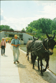
restored canal at Providence Metropark (photo by jhy)

from Rick Adamson Ohio State Trail Coordinator

Sign up to help build trail in northwest Ohio between the communities of Florida and Grand Rapids in Henry and Wood Counties.

Rick Adamson's renowned work crew will build new off-road trail on the historic Miami & Erie Canal towpath route. Accommodations are camping at Mary Jane Thurston State Park (no electric hookups).

Some food is being provided by the St. Patrick's Catholic Church, but for most meals volunteers must provide their own.

The event runs between Saturday, June 18 and Wednesday, June 22. Work times are generally from 8 am to 3 pm leaving plenty of time for recreation.

The North Country Trail currently breaks off from the Buckeye Trail in this section and heads north through Liberty Center. Come see why the trail should continue to Grand Rapids before turning north! At Providence Metropark you can experience the canal days with a ride on a recreated canal boat, and a visit to the operating Ludwig Mill.

Contact Rick Adamson for more details.

This segment is on BTA Map Defiance Section

See the Buckeye Trail

Friday, August 13, 2010

Wabash-Cannonball Connection Seriously Damaged

alt text
The photo shows the state of the damage on Nov. 11, 2009. View to South, from the trail centerline showing bulldozer and backhoe damage of NORTA property. Water flowing onto the trail ditch on S. side of trail approx 1800 W. of Co. Road 16

OutdoorBlips: vote it up!
if you like this article, click the Blip chiclet!
from the Cannonball Courier, the NORTA newsletter, July 2010, by Jay Budde

In November 2009, the NORTA Board of Directors learned of a serious incident of damage to the trail in Williams County between Williams County Roads 16 and 15. The damage appeared to have occurred as part of an adjacent landowner’s attempt to drain his land. Heavy equipment, believed to include a bulldozer and backhoe entered NORTA property, crossing and destroying a fence that was clearly marking the southern boundary of NORTA property. Earthmoving equipment cut through a natural embankment blocking drainage from the adjacent landowner’s property and opened a 4 foot wide by 5 foot deep trench draining directly onto the trail.

During the spring and summer of 2010, surface drainage flows, as a result of this damage and heavy spring rains, have eroded the trail surface in this area. The Board is attempting to work with the parties believed to have caused this damage to restore the trail to its condition before the damage.

Although this is slightly west of where the North Country Trail leaves the Wabash-Cannonball trail and heads north, the resources needed to deal with problems of this magnitude divert attention from other improvements.

NORTA, Northwest Ohio Rails to Trails Association

Wednesday, May 26, 2010

Buckeye Trail Work Week Signup


from Rick Adamson

The Ohio State Trail Coordinator for the Buckeye Trail/ NCT announces a work week on the Miami and Erie Canal towpath, June 2-6, 2010.

This will continue the project of connecting off-road trail from Defiance to Grand Rapids, Ohio. Camping will at Mary Jane Thurston State Park, and food and refreshments should be provided by participants, with the exception of Wednesday when dinner will be hosted by Joe & Cindy Krueger.

Tools and training are provided free of charge by Jim Runk, and Assistant State Trail Coordinator. Certified first aid persons are part of the volunteer staff.

Rick

P.S. from JHY- I have personally participated in one of Rick's work weeks on this section. They are very well organized, and you will finish the week feeling very satisfied that you have been a part of the team, and important to the accomplishments, no matter what your skill level.

This segment is on BTA Map Defiance Section

See Buckeye Trail

Tuesday, November 24, 2009

Tar Hollow - Ohio Spotlight

tar hollow state forest sign
(photo by JHY)


OutdoorBlips: vote it up!
if you like this article, click the Blip chiclet!
based on a news release of the Akron Beacon Journal

Tar Hollow State Forest in south-central Ohio is often overlooked in favor of the better known Old Man's Cave or Hocking Hills. Tar Hollow State Park is just 619 acres within the 16,000 acre state forest. But this very natural park offers plenty of what Ohio used to be like before it was heavily settled.

The area is known for steep ridges and deep ravines. On the dry ridge tops one can find oaks, hickories, shortleaf and pitch pines. Along the rivers the black willow, sycamores, and buckeyes abound. The area is located in the sandstone hills that transition to the Allegheny Plateau.

tar hollow fire tower
Brush Ridge fire tower (photo by JHY)
The forest was named for the tar from the pitch pines. It was a staple for early settlers who used it for everything from liniment to lubricant. It was also distilled into turpentine.

The forest has an extensive trail system roughly in a figure 8. At the center of the system is the Brush Ridge Fire Tower. The Buckeye / North Country Trail reaches this point from the SE, and then makes a sharp turn at the tower to the SW.

One could easily spend a long weekend at Tar Hollow. In all, there are 24 miles of hiking trails, and 2.5 miles of mountain bike trails. There are five backpacking campsites and seven overnight log shelters. 25 miles of bridle trails also traverse the forest, including a horse camp.

Wildflower enthusiasts will find southern Ohio to be spectacular in the springtime.

tar hollow fire tower
violet wood sorrel (photo by JHY)


The Tar Hollow Region stretches from points 2 to 7 on the Scioto Section of the Buckeye Trail Maps, for 11.7 miles of off-road trail. Camping is allowed near the fire tower (no water).

The Beacon Journal article gives much more information about the local area.

See Buckeye Trail
See Tar Hollow State Forest


Friday, October 2, 2009

Young Passes 4000 Mile Mark

Joan Young
taken at the Milford Trail Junction Festival

OutdoorBlips: vote it up!
if you like this article, click the Blip chiclet!
by JHY

Wednesday, Sept 30, yours truly passed the 4000 mile mark hiking the North Country Trail. I can hardly wrap my head around the idea that I have now hiked that many different miles of the trail. The momentous event occurred within a mile or so of Brown Bridge near Mt. Orab, Ohio.
Brown Bridge
Brown Bridge


I still have another 60 miles to go to finish Ohio, and I'll be headed back out tomorrow to work on those. Today I've enjoyed a restful day, out of the rain, at Steve and Sharon Boller's home in Milford. Those who attended the North Dakota Conference may remember meeting them, and they are part of the group working to develop the Trail Junction Park.

There really is something emotionally magical about that 4000-mile mark. Although I've been saying for months that I plan to finish the trail soon, I finally feel like it is really going to happen!

For some stories about my Ohio adventures, visit My Quality Day
See Milford, Ohio- Embracing the Trail Town Concept

Sunday, September 27, 2009

Milford, Ohio - Embracing the Trail Town Concept

Trail Junction sign
the sign which will be placed at the actual junction of the eight trails, with Joan Young and Ron Strickland (photo by JHY)

OutdoorBlips: vote it up!

if you like this article, click the Blip chiclet!
by JHY

The sycamore leaves were twirling on a lazy breeze, and the rain which had fallen all week backed off to at least a trickle, as the Citizens for a Better Milford hosted the 4th Annual Trail Junction Festival. A town crier rang his bell and Mayor Charlene Hinners presented certificates of appreciation to several members of the Citizens Group.

Trail Junction festival displays
each trail had a display (photo by JHY)


Not only was each of the eight trails which meet in Milford, Ohio represented, many of them gave presentations throughout the day. Attending for the North Country Trail were Andrew Bashaw, Regional Trail Coordinator for Ohio/Pennsylvania, and Joan Young, hiker. Another face familiar to many NCT folks is Ron Strickland who explained the Sea to Sea Route which will include the North Country Trail.

Milford has a plan which, if brought to fruition, will set the bar very high for trail towns. In keeping with the theme, they hope to build a Trail Junction Park. This area along the Little Miami River includes everything from an elevated road crossing to safely bring hikers and cyclists across a busy highway to a hotel! Two camping areas are also included in the park, and a large conservatory for botanical displays.

Trail Junction park master plan
Trail Junction park Master Plan (photo by JHY)


The key element of the park will be an eight-sided building, with one entrance on each face dedicated to one of the eight trails. As a person enters the building they will be able to see displays, a mini-museum about the designated trail. On the second floor of the building will be classrooms which could be used for education, workshops, etc. and offices where he hopes each trail will want to situate a staff member. And the top story of the building will be an open room for large meetings, banquets, etc.

Some NCT folks will remember Steve Boller, and wife Sharon, who attended the Annual Conference in North Dakota this summer. Steve, a retired lawyer, is one of the key players in the Citizens for a Better Milford group. They note that the small city was pleased to discover that they have a single meeting point for so many trails, and believe that the feature is too unique to ignore.

Steve Boller
Steve Boller poses beside the Master Plan (photo by JHY)


It's unlikely that this plan would come to fruition in time for the Annual Conference 2011, but after spending a weekend with this energetic group, it wouldn't surprise me a bit to see Conference 2018 in Milford, Ohio!

See Trail Junction Festival
See Junction Trails Park Newsletter

Friday, September 25, 2009

Trail Junction Festival Tomorrow - Milford Ohio

Trail Junction Festival logo

OutdoorBlips: vote it up!
if you like this article, click the Blip chiclet!
a news release of Rails-to-Trails Conservancy

The Trail Junction Festival in Milford, Ohio kicks off tomorrow, Sept 26, for two days of trail fun. The purpose is to celebrate and bring awareness to the over 22,000 miles of Long Distance Hiking, Cycling and Paddling Trails that converge in Milford.

Milford, Ohio is situated at a unique crossroads of America's Long Distance Trails. They celebrate this connection at The Junction! The Fourth Annual Junction Trail Festival in Milford celebrates the following trails:
  • Buckeye Trail
  • North Country National Scenic Trail
  • American Discovery Trail
  • Sea to Sea Long Distance Hiking Route
  • Underground Railroad Cycling Route
  • Ohio to Erie Cycling Route
  • Little Miami Scenic Trail
  • Little Miami Scenic River


A number of NCT folks will be there, including Joan Young, with a slide show, and informal question session, book sales and signing. Andrew Bashaw, OH Regional Field Coordinator for the NCT, and BTA executive director will represent our trail, and Ron Strickland will promote the Sea to Sea Route.

Hike, paddle, bike, go fishing, eat ice cream and enjoy a campfire. Everyone is praying that the predicted rain will hold off.

If you live anywhere near... it should be great.

Trail Junction Festival

Sunday, September 6, 2009

Sheepskin Hollow, Ohio - A Treasure of the NCT

Jack's Lookout Sheepskin Hollow Nature Preserve, Ohio
view from "Jack's Lookout" (photo by JHY)

OutdoorBlips: vote it up!


by JHY with material from a news article at Ohio.com, "Pristine, wild beauty - Sheepskin Hollow is difficult to access, but worthwhile," by Bob Downing

Sheepskin Hollow is one of the wildest spots left in Ohio, according to Bob Downing. It is a 453-acre nature preserve in Columbiana County at the eastern edge of Ohio. It nestles in the North Fork of Little Beaver Creek.

Any North Country Trail hiker who has crossed that river on the old, narrow, rusty truss bridge and then turned steeply uphill into the woods just a few yards east of the river has entered Sheepskin Hollow.

Sheepskin Hollow has no amenities: no parking lot, no rest rooms, you may be lucky to find a blue blaze. In fact, when I hiked there in 2003, we found old blue blazes farther up the road that led us astray.

Another way to enter the Sheepskin Hollow Nature Preserve is to park by a railroad overpass off Pancake-Clarkson Road and head south on foot along the old elevated rail bed for a half mile in Middleton Township. After a short walk you will find a small sign indicating that you have entered the preserve.

Downing says, "Then you suddenly come to an opening on the left that drops off into a pretty rock-walled gorge lined with hemlocks. No sign. Just go for it."

The preserve contains a small stream in a ravine with sandstone and shale walls. The maple and oak, beech and hemlock, are more often found in forests farther north. "I poked around a bit, saw one of two waterfalls in the three-quarter-mile-long hollow and was impressed by the wild ferns and eye-popping spring wildflowers," continues Downing.

The state has no plans to improve Sheepskin Hollow. Manager Charlotte McCurdy said, "It is one of the most unique state nature preserves in Ohio...It's as natural as you can get in Ohio."

The land previously belonged to the Vodrey family who began to acquire it in the 1920's. The stat began to purchase the preserve in 1986. Jackman Vodrey explained that the name came from a sheep farm which operated at the head of the stream. In the past the area has both been logged and mined for coal.

Now it is an area where such unusual plants (to Ohio) as speckled wood-lily, pipsissewa, pink lady's slipper orchid, Bicknell's panicgrass, and Canada fly-honeysuckle are found. The preserve is a haven for birds, labeled as "Important" by the Ohio Audubon Society.

And the North Country Trail traverses Sheepskin Hollow! The Great Trail Sandy Beaver Canal Chapter of the North Country Trail Association has been working hard to forge agreements to connect the trail through the preserve on to Little Beaver State Park to the west. At the present time, the trail actually dead-ends just beyond the overlook shown in the picture. A potential right-of-way has been identified, but thru-hikers need to be sure they do not stray onto private property.

The Division of Natural Areas and Preserves is sponsoring a guided hike with McCurdy on Sept. 26. The hike to the western tract will be at 10 a.m. Advance reservations are required. A maximum of 30 people can attend. Call 330-527-5118 for reservations.

Great Trail Sandy Beaver Canal Chapter of the NCTA

Wednesday, July 15, 2009

Where is Nimblewill?

Nimblewill Nomad
Nimblewill Nomad
OutdoorBlips: vote it up!
personal communication and Nimblewill's Journal

Just this morning, Nimblewill Nomad contacted Bruce Matthews, NCTA Executive Director, with the following message, "I'm healthy and hiking strong. Am in Logan, Ohio today. I got behind on my journal entries, then my webmaster got loaded up with other chores. So, the excuses.

Thanks so much for your concern--will try to keep up better for the remainder of this trek.

God Bless, Eb

As of today, his most recent journal entry is June 29, after passing through St. Marys, Ohio. He noted some canal towpath sections that need maintenance badly, and then others that were a joy to walk. He also noted his 100th day on the North Country Trail.

We hiked together,
Hearts of pride.
Far o'er these ancient
Mountainsides.

from Nimblewill's poem "Through Trails"

Sunday, July 5, 2009

Volunteers and Appreciation from State Agencies

commentary by JHY based on emails from several volunteer leaders

Sometimes it's difficult to understand the reasoning of government agencies. North Country Trail volunteers provide hundreds of hours of manpower to maintain the trail on state-owned lands.

In Ohio, the DNR has re-asserted their rights to 47 miles of Miami-Erie Canal towpath. Volunteers are working hard to restore a treadway which will be off-road NCT. These work parties are allowed to camp for free at an Ohio state park. It seems to me that this is the model that makes the most sense. Everyone benefits from this type of arrangement. The state receives value in work accomplished, the volunteers feel appreciated, and everyone gains safe, usable trails.

In Wisconsin, volunteers may camp for free at Copper Falls State Park group camping during the trail work sessions. However, they must pay the park entrance fee. Only since last year has the Wisconsin DNR allowed volunteers to camp for free at the state forest Two Lakes Campground while maintaining trail nearby. It sounds like Wisconsin has been thinking about sensible solutions.

In Michigan, the situation is much worse. In the Upper Peninsula a volunteer group occupied three state forest campground sites for six nights. During that time the group built a bridge and did other trail maintenance work, often putting in more than eight hours a day. The group was charged $270 in camping fees.

In the lower Peninsula, there have been ongoing similar problems, charging volunteers to camp in order to do work which saves the state money. One particular incident pertains to the closing last year of the Pinney Bridge Campsite. The site was closed indefinitely when the DNR's money ran out (it has since been re-opened). The closure of that site effectively closed an entire section of the NCT to long-distance hikers since that site is the only place camping is allowed in the Jordan River Pathway. It also shut out the volunteers who had been camping there to maintain the Jordan River Trails.

At least one Michigan lawmaker has been notified of this situation.

How do you feel about the attitude of state agencies toward volunteers? Feel free to leave comments.

Saturday, July 4, 2009

Couple Backpacking the Buckeye Trail

Peter & Joyce Cottrell
Peter & Joyce Cottrell (photo by Faye McNabb)
based on a news article in the Evening Leader, "Couple Hikes Trail," by Katie Yantis, June 19, 2009

Beginning at the small town of Richmondale this spring in southern Ohio, experienced hikers Peter and Joyce Cottrell plan to return there in September 2009. In 2003 the Cottrells were the first people to backpack the American Discovery Trail. The ADT is concurrent with the Buckeye Trail across southern Ohio. The North Country Trail also follows about 800 of the 1400 miles of the 1400-mile Buckeye Trail loop.

On June 19, the Cottrells reached St. Marys in northwest Ohio. The Heritage Park Trails District Director Allison Brady, who has hiked the Appalachian Trail, said she recognized what the Cottrells were doing. She offered them some help and a day without their 45 pound and 30 pound backpacks. She also bought them dinner and offered a place to spend the night. The kindness of people they meet never ceases to surprise the couple.

The Cottrells said they have enjoyed about Ohio, especially the local people. “I am really loving the birds,” Joyce Cottrell said. “We are really loving the people.” She really enjoyed sharing their story with a group of ladies in a coffee shop in Bremen.

“We get simple pleasures out of the Buckeye Trail,” Joyce Cottrell said. “This is all we do, we live a very simple life, and we are trying to make people understand you can do anything you want to do.”

See the Cottrell's story on the American Discovery Trail
See The Buckeye Trail

Thursday, April 30, 2009

Buckeye Trail Celebrates 50th Anniversary This Year

map of the Buckeye Trail
based on a news release in the Columbus Dispatch, "Buckeye Trail cuts circular path through amazing diversity of Ohio"< by Steve Stephens, April 26, 2009

No matter where you go in Ohio you are likely to run into the Buckeye Trail's blue blazes.

The longest single-state loop trail in the US, the Buckeye Trail is 1440 miles long. The NCT is concurrent with it for about 800 of those miles. "The trail follows dedicated gravel or dirt hiking paths, old canal towpaths or railroad rights of way, county roads and even a few city sidewalks. It cuts through vast forests, skirts industrial land and farm fields, passes museums and historical sites, descends into beautiful, steep valleys and traverses seemingly unending plains."

Gary Williams, board member of the Buckeye Trail Association, explained that there is very little public land in Ohio. But where the trail follows roads, the route is chosen to find roads that are very little used. "Sometimes, you can hike on these roads all day and never see a car, " Williams commented.

This year is the 50th Anniversary of the trail, and in addition to the many hikes that are planned, there will be a special celebration June 12-14 at Camp McPherson near Danville.

About 100 people have hiked the entire loop. One weekend a month there is a hike that works at the continuous loop, so that dedicated participants can complete the entire trail, given enough time.

To kick off the 50th anniversary of the trail, the Buckeye Trail Association will hold a special celebration May 16 at the Grandma Gatewood trail section in Hocking Hills. in the Hocking Hills. "Grandma" Emma Gatewood, at age 67, in 1955, became the first woman to hike the entire Appalachian Trail.

Gatewood became one of the primary supporters of the Buckeye Trail project and reportedly donated the money to buy the first few pails of blue blaze paint, used on the trail through the Old Man's Cave area. The May 16 adventure will begin at 10 a.m. with a ribbon-cutting and a 6-mile round-trip commemorative hike.

See Buckeye Trail Association

Tuesday, April 28, 2009

Buckeye Work Party to Continue Towpath Recovery

trail crew cutting trail
working on the Miami-Erie towpath trail in 2003 (photo by JHY)
submitted by Rick Adamson, BTA Trail Coordinator

The Buckeye Trail / North Country Trail towpath section east of Defiance, Ohio, will be the site of another multi-day work session, May 5-9.

Several years ago the Ohio DNR decided to take advantage of the fact that they still owned the right-of-way for the 150-year-old Miami-Erie Canal. In a number of places where the route had not been overcome by trees or plowed under by farmers the BT/NCT was already using this pathway. But the DNR determined that there were another 47 miles of off-road trail that could be added to the system, and they decided to act on this.

So for several years, the Buckeye Trail has been hosting work crews to recover these miles of towpath which are often completely overgrown. For this work party, camping will be at Mary Jane Thurston State Park. There are fire rings and flush toilets.

Work will begin at 8 am each morning and conclude at 3 pm most days and noon on Saturday, the final day. Participants need to provide their own food and water.

There are all levels of work and trail building abilities needed. If you are interested in weed which will leave you with a sense of real accomplishment, contact Rick and sign up to help.

Contact Rick Adamson

See Buckeye Trail Association

Saturday, April 25, 2009

Trail Work in Eastern Ohio

alt text
lock remains on the Sandy Beaver Canal in Beaver Creek State Park (photo by JHY)
based on community news in the East Liverpool Review, with additional information

The Great Trail - Sandy Beaver Canal chapter of the North Country Trail Association has scheduled a work day for at 9 a.m. Saturday at Beaver Creek State Park. The meeting place is the primitive campground on Leslie Road at the park's main section.

The chapter is to begin working on adding a new section of the North Country Trail west of the state park. This is very good news, as there is currently a road walk from the Park all the way to Lisbon.

Volunteers are welcome, as well as youths wishing to perform community service. Tools will be provided, but dress appropriately and bring your own food and drinks.

For more information, contact Brad Bosley
or Andrew Bashaw

Sunday, April 12, 2009

American Chestnut Trees for the Wayne NF

planting chestnut seedlings
Gary Willison assists Jamie Grinch, a Boy Scout from Troop 73 from Grandview, Ohio to plant a chestnut seedling. (photo from USFS)
excerpted from National Forest Success Stories "American Chestnut Trees Planted on National Forest Reclaimed Mine Lands," by Gary Chancey, April 4, 2009, used with permission

Special American chestnut seedlings developed by US Forest Service Research are planted on the Wayne National Forest, in SE Ohio, with hopes for better survival, growth and development of seedlings.

Almost one-thousand blight resistant American chestnut trees and 200 disease resistant American elm trees were planted in early April by Boy Scouts from Columbus, Ohio, as well as Forest employees from the Watershed Restoration Group and local volunteers.

The seedlings were planted on a piece of reclaimed mine land that was restored last year in Athens County. The Forest planted 600 American chestnut trees on the Ironton and Athens Ranger District in 2008. This year, the Forest estimates 3000 of the trees will be planted by the end of April on both districts. The project is in partnership with researchers from the U.S. Forest Service Research Lab in Delaware, Ohio.

The American chestnut tree was nearly wiped out by a blight that killed an estimated four billion trees in the eastern United States in the early 20th century. The naturally surviving trees remain vulnerable to the fungus, however through years of cross breeding with its disease-resistant counterpart, the Chinese chestnut; researchers are seeking to develop a blight-resistant American chestnut.

The American Chestnut Foundation's backcross breeding program produces seed that combines the disease-resistant traits of the Chinese chestnut with the superior size and timber traits of the American chestnut. In order for the seedlings to grow in the poor soil conditions of the reclaimed mines, Forest Service Researchers inoculate the chestnut seedlings with mycorrhizal fungi that will aid in the survival, growth and development of the seedlings.

Mycorrhizal fungi play a vital role in reforestation by providing the plant several benefits that are critical for its survival and growth in a nutrient poor and hostile environment such as in reclaimed mined sites.

The re-establishment of native vegetation like the American Chestnut & American Elm has been made a priority for the Wayne National Forest. In the Forest's 2006 Land and Resource Management Plan, it lists the Forest's initiative to promote the planting of disease-resistant species on the Wayne as varieties become available.

Editors note: there are a number of places along the NCT in New York where resistant chestnut trees are growing

Tuesday, March 31, 2009

Pettisville Ohio Students Help Spring Clean Buckeye / NC Trails

based on a news article in the Toledo Blade, "Pettisville local schools students take shine to history," by Janet Romaker, Mar 31, 2009

Each year students from Pettisville, Ohio schools spend a day doing service projects. Most of the effort goes to the historic Sauder Village in Archbold, Fulton County, in the northwest corner of Ohio. But just south of their county the concurrent Buckeye and North Country Trails come from the south to Defiance and take a sharp turn to the east on the towpath of the former Miami-Erie Canal.

Students asked if there was anything they could do to help the trail. The Buckeye folks recalled the good job that Pettisville students did two years ago and organized the group of 80 young people to clear portions of the towpath between Napoleon and Grand Rapids. "The previous work ethic of the students opened up the Buckeye Trail opportunity for us this year. We talked about that with the kids, the reason why that happened," teacher Mr. Reid said.

"As students see results of their hard work, "it gives them a sense of accomplishment and they are still learning," he added.

See Buckeye Trail Association

Tuesday, March 3, 2009

Dump Site in Wayne NF Removed

army assists cleanup
An Army reservist watches fellow soldiers remove trash from a large dump on the Forest.
excerpted from National Forest Success Stories "Military Assists the Wayne National Forest", by Pam Blackburn, used with permission

The Wayne National Forest found a new partner that brings a lot of muscle to the table - literally. The US Army Reserve 779th Engineering Company came on board as a new partner and took on two monumental tasks.

The Army Reserve had been looking for a real-world training area for their equipment operators. The Wayne National Forest, as with most forests, was looking for ways to accomplish more tasks with lower budgets each year. Although they were neighbors, neither had given much thought to what they could offer each other.

The first task was an illegal dump that, according to local accounts, had been on the Forest for 60 years or more. The dump also flowed over onto private land owned by an absentee owner. The Forest contacted the owner and obtained permission to access his land to remove the dump from his property also.

During that time, the Forest met with several local law enforcement agencies to target any new dumping at the site. From that effort, approximately 35 new cases were prosecuted. Days before the cleanup effort, the Forest spoke with local residents and landowners to inform them of the dump removal.

Several residents recalled the dump being burned over the years "when the trash would get too high." Other comments included thank you and promises to protect the work that the Forest had done.

The dump was adjacent to the North Country National Scenic Trail and an eyesore for the Marietta, Ohio, section. The runoff from the dump emptied into the Little Muskingum River. The Little Muskingum River is one of the five cleanest rivers in Ohio. In their Forest Plan, the Wayne said they would protect the Little Muskingum River.

As the cleanup effort began, the Forest had no idea what they were undertaking. By all estimates, the trash was 40-50 tons with many tires strewn throughout. When the excavator was removing the first layer, it was like a spring. All of the layers underneath expanded with the release of the weight of the top layer. Each time another layer was removed, more layers would appear.

By the end of the first day, it became apparent that this site had been severely underestimated. By the end of the first day, the Forest had filled all of the rolloff dumpsters that had been ordered. We had also removed 45 tires. By the end of the weekend, we had removed 75 tires and 60 tons of trash.

The second work weekend on this site occurred in October. The dump cleanup crew was in full swing. With six rolloff dumpsters on hand and a semi trailer provided by the Ohio EPA for tires, we were ready to make progress. At the close of the first day, it was apparent that we were going to be close to filling our rolloffs again.

Waste Management came through with a container switch-out on a Sunday morning. They had seen what we were doing and wanted to help however they could. By the end of the second work day, we had come close to accomplishing this huge task. Two small areas of trash remain and a few loose tires. After that, it's just stone placement and time for the land to heal itself. All but the last can be scheduled. Our part will occur in March.

All in all, we removed approximately 160 tons of trash and over 400 tires. (We lost count when we got the human chain working well.) We also were able to repair a trailhead access road, protect a watershed, work across boundaries with our neighbors, and find a new partner.

By the end of both of these projects, [the neighbors] shook each of our hands and thanked all of us for our work at the site. There were also many promises of protecting what we had done. The Army security detail that spent the night at the dump site said that a runner had come past them on the trail early in the morning and yelled out "thank you for cleaning up that mess" as she passed.