Notice: I've taken a part-time job, and it's definitely affecting my blogging time. I'll continue to add content here as often as possible. Pertinent guest posts are always welcome.

-
Showing posts with label Finger Lakes Trail. Show all posts

Sunday, January 1, 2012

Winter Hike on the FLT/NCT

view from TenKate Bridge
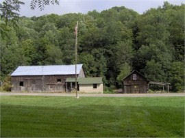
view from TenKate Bridge (photo by Terry McConnell)

by Terry McConnell

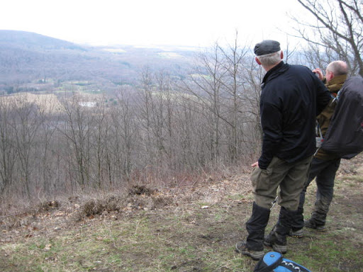
What better way to end the calendar year than with a hike on the FLT? Earlier in hunting season I had "knocked off" the long road walk of M20 along Route 11 and W. River Road, and in early October I had hiked the eastern half of M19, returning to my car on Babcock Hollow Road along the orange blazed "Dabes diversion". That left the mostly-trail segment from River Road to the top of Virgil Mt still to be done. Together with the return trip, the leg would fall neatly into my 15-20 mile sweet spot, so I slung on my day pack and headed west and uphill from my car on River Road.

From River Road the trail heads steeply uphill along the scenic rim of a small river gorge, quickly to emerge smack in the back yard of somebody's house. "Sure hope they're members," I thought as I gingerly crept by within 5 feet of a picture window, trying my best to look like a normal part of the scenery. Further along I snapped a quick cell phone pic looking upstream at the Tenkate bridge, my shaky hands conspiring with the laws of optics to produce an interesting effect I never could have gotten with forethought.

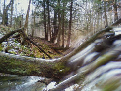
Trail conditions can be summarized in one word: slippery! Above 1600 ft. there was a uniform 1-2 inch layer of slushy snow that required a kind of stiff-legged strut to navigate any grade steeper than 5%, and which made side hill traverses dicey and dangerous. On downhill stretches through Tuller Hill SF I worked to perfect a primitive form of 'skiing' on hiking boots made possible by this slick layer. The speed gained thereby partially made up for the slow-going, but nevertheless I emerged on Carson Road a good hour behind schedule.

Read the rest of Terry's interesting adventure at Finger Lakes Trail email group, and consider joining to always know what's going on.

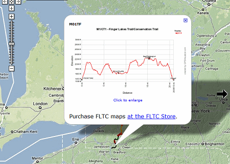
This segment is on FLT map M19


Saturday, December 17, 2011

Hiking Allegany State Park

stream in Allegany State Park
a stream in Allegany State Park, NY (photo by Pat Coate)

from Mon@arch's Nature Blog used with permission

Pat Coate, of Mon@arch Nature Blog, recently took a hike on the North Country/Finger Lakes Trail in Allegany State Park, New York. This is the westernmost section in NY, just before the trail slips into Pennsylvania.

She writes, "The section of the trail along Brown Hollow looked down on a babbling brook whose sound was drowned out by the constant sloshing of many feet through the deep carpet of fallen leaves."

"The following weekend my family hiked the other end of the FLT in Allegany State Park. The trail starts off of exit 19 (Red House Lake exit) on Bay State Road. This too is a beautiful trail. The trail climbs fairly steadily from 1440’ to 2060’ over about a 2 mile stretch, including switchbacks. There are glimpses of the Allegheny River to the west and some nice rock formations along the way."

Follow the link above to read the rest of her entry and see more pictures.

This segment is on FLT map M1/CT1

See Finger Lakes Trail

Thursday, November 17, 2011

Land Purchases Could Preserve NY Trail

land for sale
real estate photo of the Virgil property

from Mike TenKate via the Finger Lakes Trail newsgroup

There are two plots of land for sale in Virgil, New York, that either have trail or could have trail on them that are currently for sale. As you all know changes in ownership can sometimes be a little scary for permissions. I have included links below in the hopes that maybe we can find a friend of the trail who wants to buy one (or both).

Item #1 - 238 Acres currently has about only about 50 feet of trail on it due to a funky property line we only recently became aware the trail was even on this property. It is crucial to linking Kennedy State Forest to Tone Road. This property could have the possibility with a permitting landowner to host miles of trail and eliminate nearly all of the Tone Road, Route 392, Carson Road Road walks and replace them with really nice trail and lots of it. This is a really nice property and includes a lot of Gridly Creek.

Item #2 - 28 AcresThis property is one that we worked on getting a permanent easement on over the last few years. It seemed as though it was a done deal when the property owner decided to sell it instead. She decided against an easement first due to fear of lowering the value. This property is also very nice. It is only 26 acres but due to its shape could have about a half mile of trail. It could replace the Carson Road portion of the road walk and rejoin the current trail near the Woodchuck Hollow Lean- to.

Contact Mike TenKate with questions.

These segments are on FLT map M19

See Finger Lakes Trail Conference

Monday, October 10, 2011

Finger Lakes Trail Website Offers Interactive Map

elevation example map for Finger Lakes Trail
example of an elevation profile

from the Finger Lakes Trail Conference

An interactive map for the whole Finger Lakes Trail system of ~950 miles is now online at www.fingerlakestrail.org.

You can zoom in and pan the map. Zooming in twice shows waypoints for trailhead parking, shelters, campsites (including primitive), and hunting closures (red flag waypoints). Clicking on a waypoint brings up more info about it (closure dates for hunting closures).

Clicking on an FLT copyright symbol gives the last revision date for a map and gives a link to the FLT store.

Clicking on a track (main or branch) brings up an elevation profile for that map; this can be enlarged.

Creating this map for over 950 miles of trail is an amazing accomplishment. It will be a great aid to planning hikes. It should be noted that there is much more detailed information on the printed maps, and one should not attempt a long hike without purchasing those.


This refers to the entire Finger Lakes Trail System in NY

See Finger Lakes Trail Conference

Friday, September 23, 2011

New Hickory Hills Shelter in NY


Hickory Hill Shelter
Hickory Hills Shelter (photo by Jacqui Wensich)

from Jacqui Wensich

In only THREE days, the new Hickory Hill Shelter ...a thing of beauty.

This segment is on FLT map M12

See Finger Lakes Trail


Monday, April 25, 2011

Wally Wood Hike in Western NY

alt text
view from the Abbott Loop (photo by Larry Blumberg)

from Larry Blumberg

Saturday, April 23 was another one of those 'lucky' (our 'karma' is with us) days, for in spite of a near 100% forecasted chance of rain and showers, we never felt a single rain drop from the moment we started our hike -- and the sun even popped out for a few moments !

I am writing, of course, about the annual Finger Lakes Trail Conference-sponsored Spring 'Wally Wood' Hike along the Abbott Loop on FLT Map M17, south of Ithaca, NY, in Tompkins County, home of the Cayuga Trails Club who maintain the Abbott Loop along with about 70 miles of Finger Lakes Trail.

Fifteen hikers, primarily from the Cayuga Trails Club, the Bullthistle Club, and the Triple Cities Hiking Club came out for what turned into a very nice day of hiking. In addition we also had a special guest in attendance, Steve Randall, an FLT land-owner from Swain, NY.

Tom Reimers provided the opening remarks, he talked a little bit about Wally Wood, the founder of the FLT back in 1962 (you can do the math, but that means the FLT will be celebrating its 50th birthday in 2012 !!!). Phil Dankert, who served as the hike leader (but let's be honest - he had lots of help from his buddy Jack Vanderzee), then talked about the Abbott Loop and how it was built in the early 1990's by a couple from the Cayuga Trails Club, Cliff and Doris Abbott.

Phil chose to hike the Abbott Loop in a clockwise direction, or 'backwards' from the description as written on the back of Map M17. That, to me, meant we must have been hiking COUNTER-clockwise, since we were heading COUNTER to the map description, but I was out-voted...so, yes, we hiked clockwise around the Abbott Loop. Not sure it mattered, though, cause we climbed a total of 1900 feet and to my way of thinking that's the same no matter which direction one hikes the loop!

This segment is on FLT Map M17

See Finger Lakes Trail Conference

Monday, January 17, 2011

Weekend Hiking in New York

winter hikers
Howard Beye hike (photo by J Wintski)

received from Cate Concannon

Seventeen hardy souls braved the cold to hike on Howard's section of the Bristol Hills Trail in Naples. As John & Judy pointed out, we had a wide range of hikers and I hope everyone enjoyed talking with each other while enjoying the trail. Although the sun came out when we set out, the wind picked up and a soft snow fell during the day. Although warm when moving, the wind made things pretty cool so not a lot of time was spent at Howard's bench, and only a quick lunch was had at the lean-to at the lookout spot.


leanto
Stoney Brook leanto (photo by gbd001)


received from gbd001 on fingerlakestrail hikers

My son and I spent the weekend in Allegany State Park to get in some hiking before he returns to school next week. (Don't feel bad for him - he goes to Paul Smith's and is majoring in outdoor recreation. We should all be so lucky.)

On Saturday morning we hiked into the Stoney Brook lean-to from ASP 2. Other than a xc skier who passed us on the trail it was 2 feet of virgin snow and slow going despite our snowshoes.

The lean-to was in great shape, and despite all the snow it was dry inside. We were sorry we hadn't planned to stay there (but we had one of the few cabins with a wood stove so it was a bit more rustic than a motel room.)

These segments are on FLTC maps

See Chief Finger Lakes Trail

Sunday, October 10, 2010

Tornado Hits NCT/FLT Near Rock City NY

map of FLT Tornado damage area
map from FLTC

a news release of Finger Lakes Trail Conference

The recent tornado damage from Access 2 (Little Rock City Picnic Area) to Access 3 (Old Seneca CCC Camp) is 0.7 mile long and 0.2 wide and has flattened most trees, closing the trail. A timber salvage operation and trail restoration may take up to two years, so in the meantime, bypass by using Little Rock City and Hungry Hollow Roads (brown squares). Mountain bike trails (purple dashes) may also be used to bypass the damage area shown below.

While Queens, New York, and southeastern Ohio received more publicity about damage from these September storms, the trail was also affected.

This segment is on FLTC map M3/CT3

See Chief Noonday Chapter of the NCTA

Friday, September 17, 2010

Wegmans FLTC Passport Hikes

Finger Lakes Trail / Wegmans Passport Sign
Wegmans Passport check-in location (photo by Gene Bavis)

from Finger Lakes Trail Conference

Wegmans Grocery and the Finger Lakes Trail Conference have just kicked off a great program to get people out exploring trails. Hikers can earn the chance to win great prizes from Wegmans. There are 12 locations included in the passport, but after you hike just four of them you can earn a patch, and receive coupons from Wegman's and other sponsors. When you complete 10 hikes, your name will be be added to a pool for either a $100 Wegmans gift card or a free Wegmans picnic pack for you and 20 of your friends to enjoy. These grand prizes will be awarded once each year, in mid-October.

Once you pick up your passport book at any Wegmans, or various other locations, you can begin your hikes. All maps needed are included in the booklet. Hikes are located on FLT maps L1, L2, M8, M9, B1, B3, M12, M14, M16, M18, and M19.
Finger Lakes Trail / Wegmans Passport overview map
Wegmans Passport locations


Hikes vary from 1.5 to 4 miles. Somewhere in the course of each designated hike there will be a green mailbox and a sign like the one above. Sign the trail register you'll find in the mailbox. Open the passport, and find the page designed for rubbings. Use a pencil or crayon and make a rubbing of the map number from the sign. This is your proof that you were at the location.

Complete directions for how to participate are found in the booklet.

The booklet is also available for download from the FLTC web site.

This segment is on FLTC maps L1, L2, M8, M9, B1, B3, M12, M14, M16, M18, and M19

See FLTC Passport Program

Thursday, September 2, 2010

Connection to GET Progressing via Crystal Hills Branch

connection of Great Easter Trail to Finger Lakes Trail
from fingerlakestrail.org

info from the Finger Lakes Trail Conference

The North Country Trail will soon be connected to the Great Eastern Trail (GET). The GET roughly parallels the Appalachian Trail, but on the west side of the mountains. In Pennsylvania the GET follows the Mid-State Trail to the New York border. At that point there are about 6 miles of road walk in Steuben County's Town of Tuscarora. At that point the trail enters Pinnacle State Park. Next, the trail passes through McCarthy State Forest and reaches the Village of Addison at a small cemetery. It will ultimately join the Finger Lakes/ North Country Trails. Orange blazes mark the route of the GET.
portion of Crystal Hills map
from fingerlakestrail.org


A new section of the Crystal Hills Trail is now open which continues the route from Addison. The new trail is on map CH2 and starts from where the blazing previously stopped at the corner of Maple St. and Ames St in Addison. Hike north from there through cemetery, tree farm, and woods. You come out of the woods on Mose Rd., just west of Beeman Hollow Rd. The new section is 4.0 miles long. There are also two new short spur trails, one to a waterfall and the other down to parking on NY 417. Not only is this a pretty section of trail to hike, but it eliminates the roadwalk along busy NY 417.

This segment is on FLTC map CH 2

See Finger Lakes Trail
See Great Eastern Trail Moving Closer to Connection with NCT/FLT

Monday, April 5, 2010

Triple Cities Hiking Club Hikes Near Cortland

Triple Cities Hiking Club
hikers from the Triple Cities Hiking Club (photo from TCHC)

OutdoorBlips: vote it up!
if you like this article, click the Blip chiclet!
submitted by Larry Blumberg of the Triple Cities Hiking Club

A very high turnout matched the very high temperatures (upper 70's) as 17 hikers met Saturday for a really nice stretch of Finger Lakes Trail in Cortland County on FLT Maps M21 and M20.

We started high up on Cortland Two Rd, west of the Cheningo Day Use Area in Taylor Valley State Forest. This was the spot where Susan Blumberg, Diana Liu, Karen Goodman, and I had last left off in the Fall of 2009 -- this hike was the continuation of our methodical east-to-west trek along the FLT with the self-imposed requirement that each hike be done 'in order'.

From Cortland Two Rd our hike took us over Mt Roderick, Mt Tego, across NY Rte 41, and up Solon Hill to our ending point at the intersection of Baker Schoolhouse Rd and McGraw Marathon Rd (wow, say that fast 3x times !). No question that our progress up each hill seemingly slowed as the unusually warm weather began taking its toll on us, it was only a few days ago that we had been hit with a raw cold rain.

Up on Mt Roderick we were fortunate to run into Tim Davis, a trail steward from the Onodaga Chapter of the ADK (Adirondack Mtn Club). Tim was out clearing the last of the winter blowdown from his section of trail. We very much appreciated Tim's efforts, and gave him a standing ovation (well, ok, we were already standing, but it was an ovation nonetheless !) after enjoying a nice chat with him.

Triple Cities Hiking Club
hikers from the Triple Cities Hiking Club (photo from TCHC)
Lunch #1 was taken at the register box on Mt Tego, lunch #2 at the top of Solon Hill...and for about half of us, desert was taken at the "Scoop" ice cream place in Whitney Point on the drive back to Binghamton (yes, when out hiking I am a firm believer that lunch begins the moment breakfast is over, and doesn't end till supper begins !)

This segment is on FLTC maps M20, M21

See Finger Lakes Trail

Friday, March 19, 2010

Burt Hill State Forest- Featured Location


OutdoorBlips: vote it up!
if you like this article, click the Blip chiclet!
by JHY

Burt Hill State Forest is located in New York's Southern Tier, on the Finger Lakes/ North Country Trails, between Bath and Hornell. In the video above, Ed Ressler takes you on a quiet walk from Windfall Road, east through Burt Hill to Spencer Hill Road. He is accompanied by Scrappy the dog on a lovely October day.

Burt Hill is in the town (township) of Howard in Steuben County. Agriculture was attempted by early settlers in the 1800s. But by the Great Depression and the crash of 1929, the rocky soil had been abandoned. The 403-acre forest was acquired by New York State in the 1960s. Steep terrain is common, with flat hilltops. Most of the area is accessible only on foot. The FLT/NCT passes through the northern edge.

I hiked this section in April 2002, and passed my 2000-mile mark on the NCT near here. This hike was my dog Maggie's one overnight on the NCT. It was easily determined that she was not a hiker dog! In the chapter of North Country Cache, "Thousands of Miles," I wrote:
"This is Maggie's first overnight hike. Sleeping outside is certainly nothing this comfort-loving dog has ever longed for. We reach Burt Hill Lean-to early on our first day; the woods are warm and quiet. Maggie is nervous; she chases the woodchuck, ignores the whistles of the tufted titmouse, and doesn't see the turkey, but she is not at all happy about the hammering of the pileated woodpecker. She woofs and paces and is happiest when we finally snuggle in to the sleeping bag for the night. She is bigger than Chips [my first hiking dog] was, and leggier too. She would like to be inside the sleeping bag, but there isn't room for the both of us. So the compromise is that she curls into my chest, as I lie on my side, and we pull the flap of the unzipped bag over both of us."


This segment is on FLT map M10

See NYDEC map
See Books Leaving Footprints to order North Country Cache. (one chapter is available free as a download)

Thursday, December 3, 2009

New Robinson Loop Trail in NY Southern Tier

Robinson Loop Trail

OutdoorBlips: vote it up!
if you like this article, click the Blip chiclet!
an email from Ron Navik

The Robinson Loop trails have been constructed between Swain (access point 3) and Garwoods (access point 4) off the Finger Lakes Trail. This adds 6 miles of new side trail running through woods and occasionally along the edge of a field, all of it maintained as a private wildlife preserve. You can make loop hikes with a variety of distances by combining the trails. Access is from Isaman Hill Road and from the main FLT.

This segment is on FLT map M8

See Finger Lakes Trail

Sunday, November 22, 2009

Manlius NY Couple Wins FLTC Clar-Willis Award

Bill and Anne Brosseau
Bill and Anne Brosseau (left) with Jon Bowen (photo from ADK Mountain Club)

OutdoorBlips: vote it up!
if you like this article, click the Blip chiclet!
based on a news article in the Syracuse Post-Standard

The Clar-Willis award is bestowed annually by the Finger Lakes Trail Conference on a distinguished trail volunteer or couple. At the fall meeting of the Adirondack Mountain Club this past weekend, Bill and Anne Brosseau, of Manlius (near Syracuse, New York) received the honor.

John Bowen, chairman of the Adirondack Mountain Club - Onondaga Chapter, presented the award. The Brosseaus have made a significant contribution over a period of time as trail workers.

The Clar-Willis award was named after Henry Clar and Edward Willis, early Finger Lakes trail volunteers. They exhibited outstanding dedication and long time service in building and maintaining many miles of the Finger Lakes Trail system. The Finger Lakes Trail and North Country Trail are concurrent for approximately 300 miles through central and western New York.

See Finger Lakes Trail Conference


Thursday, October 29, 2009

New York Erv Markert Hike

hikers with umbrellas
Erv Markert hikers (photo by Larry Blumberg)

OutdoorBlips: vote it up!
if you like this article, click the Blip chiclet!
submitted by Larry Blumberg

Led by John Morris's stand-ins, Alex and Michelle Gonzales, ten of us truly enjoyed a wet, drippy, and at times dreary-looking day out on the Finger Lake Trail's Spanish Loop (FLT Map M19) west of the Greek Peak Ski Resort.

This was the Erv Markert Fall Hike, the third in an annual series of FLTC "named hikes" (just in case you were wondering, the Spring hike is named after the FLTC's first president, which was back in the '60's, Wally Wood; and, the Summer hike is named for Ed Sidote, who currently serves as the FLT's end-to-end coordinator).

While John had planned our hike and had certainly intended to be our leader, knee problems limited him to meeting us at the start and finish of the hike. However, he took on that mission with a zeal - he secured free drink coupons for us for after the hike over at the Gatherings Restaurant near Greek Peak. So, John, feel free to "lead" a hike for us anytime!

hikers with umbrellas
Spanish Loop Trail (photo by Larry Blumberg)


All told, between the Spanish Loop and a couple of side loops off the Spanish Loop, plus some additional mileage on the FLT over to the site of what may have been an old mine of some sort, we covered about 7 wet miles... it was a good test of our rain and foot gear !


See more pictures from this hike
See Finger Lakes Trail


Friday, October 16, 2009

Ithaca's "Emerald Necklace" Includes FLT/NCT

hills south of Ithaca
hills south of Ithaca on the FLT/NCT (photo by JHY)

OutdoorBlips: vote it up!
if you like this article, click the Blip chiclet!

based on a news article in the Ithaca Journal

The Emerald Necklace Greenbelt is the name for the long-term conservation plan for 50,000 acres surrounding Ithaca, New York. This plan, recommended by the Finger Lakes Land Trust, includes nine state forests, Connecticut Hill Wildlife Management Area and Cornell University's Arnot Forest.

Wending through that area is the Finger Lakes and North Country Trails. Andy Zepp, the Finger Lakes Land Trust Executive Director, says that the sprawling development patters of the area will create problems.

Preserving a 300 foot wide corridor, for recreation and wildlife, to be obtained through purchases and easements, would help protect 78 miles of the trail. Currently, very few of the FLT trail miles are legally protected. A great many handshake agreements exist, but when land changes hands such casual agreements fall apart.

The Land Trust seeks to protect the entire FLT through conservation easements, donation or purchase of land, and simple easements. No land is claimed through eminent domain, rather the land trust works with land owners.

One goal of the Emerald Necklace is to develop four gateways to a trail system, which includes the FLT/NCT. Proposed locations are:

- In the Town of Hector, Schuyler County, along Route 79, somewhere between the Finger Lakes National Forest and Texas Hollow State Forest.
- In the Town of Ithaca, on state land on the east side of Route 13 across from
- In the Town of Danby, within Jennings Pond Park on Bald Hill Road, near Route 96B.
- In the Town of Richford, Tioga County, along Route 79, somewhere near the Tompkins/Tioga border and Robinson Hollow State Forest.

Finger Lakes Land Trust

Tuesday, October 13, 2009

Long Distance, Single Use Foot Trail


OutdoorBlips: vote it up!
if you like this article, click the Blip chiclet!
by Bill Coffin: condensed from the Finger Lakes Trail News, Fall 2009

Single-track trail mileage limited to hikers is the backbone of the Finger Lakes Trail, and it needs better protection from mechanical impact. Last year there was a proposal in Albany for a statewide multiple use trail system, which would be a disappointment to hikers since it fails to recognize the value of single use hiking trails. Something must be fundamentally wrong if conservation does not encompass saving a continuous track solely for the foot traveler.

Seeing nature at its very best, which is a major purpose of hiking, requires a foot trail with a wilderness character. To often the hiking experience gets lumped with other types of trail usage. It is wrong to believe that the woods should look the same to everyone and that multiple use trails are the answer. Wilderness is the experience hikers seek.

The heaviest and fastest trail usage determines the final shape and appearance of a multiple use trail and also dominates the experience of other when they are on the trail. Unfortunately, on multiple use trails the hiking experience comes last.

The FLT [and great portions of the North Country Trail] is a long distance, single track hiking trail, reflecting the only kind of long-distance land travel that existed in North America 500 years ago. The Finger Lakes Trail brings back a semblance of wilderness pre-history. It is a highly valuable conservation and recreation resource that merits protection as a single-use footpath.

Finger Lakes Trail

Friday, July 17, 2009

Finger Lakes Critical Easement from an Interesting Landowner

Jean Pitt
Jean Pitt (photo by Mary Coffin)
OutdoorBlips: vote it up!
based on an article in the Finger Lakes Trail News, Summer 2009, by Mary Coffin

A small, but critical, segment of the Finger Lakes / North Country Trail is now permanently protected through an easement granted by Mrs. Jean Pitt of Delphi Falls, New York.

The easement allows passage of the trail across 2/3 of a mile which connects the Onondaga Branch of the Finger Lakes Trail to the Highland Forest County Park. From Highland Forest, the North Country Trail proceeds to the east.

Mrs. Pitt (nee Grimes) has emerged as one of the more colorful landowners along the trail. Her father was a son of slaves, and he was the first African-American to purchase land in the town of Pompey. The Grimes family became prosperous farmers, despite the difficulties facing black families in the early 20th century. Using information from Cornell University publications the family raised high-quality produce and eggs, often purchased by Syracuse University.

The land of her childhood memories is important to Jean. She recalls wildflowers and berry picking. She mentioned a year where pockets of late snow allowed the family to make ice cream to eat with their berries.

Jean went on to Syracuse University, and then to Case Western for graduate studies. She had a forty-year career as Director of Social Services at the VA hospital in Syracuse.

Generally speaking, the Finger Lakes Trail has led the way in teaching the North Country Trail folks how to build relationships with landowners. Hikers can undo those relationships quickly when they ignore landowner requests, such as "no camping," "no passage during hunting season," etc. Good trail courtesy will help ensure that the trail will be there for hikers far into the future. In many cases, the trail is allowed across private property only by a handshake agreement. One disrespectful hiker can sour a landowner for a long time.

We all thank people like Jean Pitt who value trails and are willing to enter into a legal arrangement to preserve connections for hikers.

Finger Lakes Trail

Thursday, July 9, 2009

Trail Connections to Naples, New York

Grimes Glen Falls
a 60-foot cascade in Grimes Glen (photo from NYfalls.com)
from various sources

New York State Office of Parks, Recreation and Historic Preservation announced $3.3 million in grant awards for 32 trail-related projects around the state as part of the federal Recreational Trails Program. The grant awards were announced June 23.

“New York’s expansive trail system offers four-seasons of recreation for all who live and visit our great state,” said State Parks Commissioner Carol Ash. “Through these grants, New York will help connect people to the spectacular scenery and wide open spaces across the Empire State, while helping to improve the quality of life and economies of host communities.”

Funding is provided through the Federal Highway Administration's Safe, Accountable, Flexible, Efficient Transportation Equity Act: A Legacy for Users, usually known as SAFETEA-LU.

In Ontario County, $80,000has been granted for a spur to the Finger Lakes Trail System's Bristol Branch. The four-fold purpose of the Finger Lakes Trail Spur at Grimes Glen County Park project is to improve accessibility and usability of the trail at Grimes Glen, while increasing the overall connectivity between trail resources in the region.

The link will include signage, both route-finding and interpretive, along village streets and sidewalks to connect the Grimes Glen County Park to the entire Finger Lakes Trail, and also to the North Country Trail.

In November 2008, The Finger Lakes Land Trust and Ontario County partnered to acquire and permanently protect the heart of Grimes Glen in the Town of Naples, New York. The 32 acre property was purchased from Naples resident Don Braun.

Funds for the land purchase were raised by the Finger Lakes Land Trust and title to the property was transferred to Ontario County to manage as a public park. The Land Trust retains a conservation easement on the parcel.

Grimes Glen features a trail leading to two 60-foot waterfalls. In the spring wildflowers carpet the glen.

See CNYlink,"County receives park and recreational grant"
See Finger Lakes Land Trust, "Grimes Glen Protected"
See NYfalls.com Grimes Glen County Park

Friday, July 3, 2009

Hike Sampler Series in New York

hike sampler graphic
from the Finger Lakes Trail Conference

The Finger Lakes Trail Conference has planned an interesting series of hikes this summer to help people who consider themselves novice hikers to become more comfortable on the trail.

This series of three guided hikes, named Hiking 101, is geared towards the those with little or no hiking experience, and will cover a total of more than 16 miles (each hike is 5 - 6 miles). The hikes will take place in three different New York counties (Allegany, Ontario, and Livingston Counties) and sample some of the beautiful and varied hiking on the Finger Lakes Trail.

Following the final hike there will be a picnic for the participants.

Registration has been extended until July 9, 2009.

For complete information, see Sampler Hike Series