Notice: I've taken a part-time job, and it's definitely affecting my blogging time. I'll continue to add content here as often as possible. Pertinent guest posts are always welcome.

-
Showing posts with label new trail. Show all posts

Saturday, May 28, 2011

Tangled to Trail in NY

Bill Zimmerman and Jersey

from the Central New York Chapter newsletter, May 2011, by Bill Zimmerman

Anyone who worked on convertng the LVRR former rail-bed, which had been abandoned for 40+ years, to a fine trail from Nelson Road West to Cottons Crossing, [near Cazenovia, NY] will remember the tangled mess of grapevines, downed trees and honeysuckle bushes. Work was slow, as the narrow path was cut into the thick brush and only a few volunteers could cut at the lead with others passing the cut brush to the rear. Other folks worked on finding and clearing places to pile cut brush off to the side.

Today, this trail winds gently and is still very narrow, meandering along the Canastota Creek. With much of it barely four feet wide, it doesn’t have the appearance of an old railroad bed. To begin with, the new trail was rough and needing improvements to the walking surface including removing stumps, surface vines and some fallen trees. People have been slow to find this trail but usage is steadily increasing in number including hikers, dog walkers, cross country skiers and even some horses.

Horses are not authorized for the trail because it is very narrow and the walking surface can’t support them. This past year, I requested, received, and put up a trail register box which is about 100 yards West of Nelson Road. It was exciting to see an entry the same day the box was installed. Most entries are just a date and name but some are interesting.

Even though Jersey and I walk this trail almost every day, the new register shows more folks are using it than what we have seen or thought. The trail register is a good tool to gauge the usage of a trail. So if you want a different hiking experience, please come to Nelson Road West-Cottons Crossing. Parking is available at both trailheads.

See Central New York Chapter of the NCTA

Thursday, January 27, 2011

New Trail to Little Garlic River

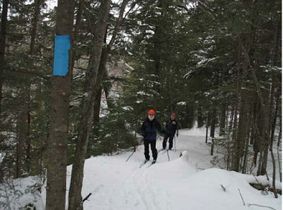
hikers wearing orange
Chuck Ganzert & Puck Bates skiing on new trail along the south side of the Little Garlic River. (photo from NCT Hikers "Footprints")

from Footprints, Winter 2011

Once the season’s trail maintenance was completed, the NCTH trail crew began building a 4.2 mile new segment of trail. From the north end of Segment 16 - Little Presque Isle Point to Echo Lake Road, the new trail segment crosses Echo Lake Road and then enters the woods winding up the hill, following the ridge to a nice view (when leaves are off the trees) of Lake Superior. From here it turns northwesterly meandering through the woods sometimes following old logging roads as it passes Gokey Rock.

Eventually a spur trail up Gokey Rock will give hikers a chance to climb up, take a break and enjoy the view. From Gokey Rock, the trail continues more northerly as it heads to the south side of the Little Garlic River. At the river it turns east following the ridge to County Road 550.

At 550 turn left to cross the Little Garlic River bridge and then into the parking area at Elliott Donnelley Wilderness.

hikers wearing orange
new trail map (from NCT Hikers "Footprints")


This new segment replaces Segment 17 - Eagles Nest Road (Echo Lake Road) to Elliott Donnelley Wilderness and eliminates two crossings of County Road 550.

This segment is on NCTA map MI-11

See North Country Trail Hikers Chapter of the NCTA

Saturday, February 20, 2010

New Trail to Cross Knife River on SHT

Knife River trail bridge
new Knife River bridge (photo by Gayle Coyer)

OutdoorBlips: vote it up!
if you like this article, click the Blip chiclet!
from the Ridgeline, the magazine of the Superior Hiking Trail Association, winter 2010

A new 6.4-mile section of the Superior Hiking Trail, south of Two Harbors will be opened in mid-May, 2010. This section goes from Fox Farm Road/ East Trailhead to Rossini Road, crossing the West Branch of the Knife River.

Trail Construction Supervisor, Larry Sampson, and more than 70 volunteers put in over 1000 hours on the project. The section features nice maple forests, huge beaver-chewed stumps, and over a half mile of old beaver ponds.

The SHTA is currently working on the map for this new piece of trail. They have scheduled a guided hike for July 17, 2010, beginning at 10 am. Meet at the Fox Farm Road/ East Trailhead.

This segment will be issued by the SHTA soon

See Superior Hiking Trail Association

Monday, December 7, 2009

The Future NCT Hudson River Crossing?

Delaware & Hudson RR Bridge
Delaware & Hudson RR Bridge (photo from CNY Hiker)

OutdoorBlips: vote it up!
if you like this article, click the Blip chiclet!
excerpted from CNY Hiking with permission

Currently there are no North Country Trail signs, no blue blazes, no trail markings on this future section of the North Country National Scenic Trail in the Adirondacks. That won't keep this 1.6 mile section from being part of our "Best of the North Country Trail" series prior to officially becoming the North Country Trail. We believe this future section will likely become one of the favorite sections of many NCT hikers and will surely be part of many future hiking guide books. This may even become one of those must hikes in the Adirondacks. And, yes you can hike this wonderful section now!

This 3.2 mile round trip hike features the old Delaware & Hudson Railroad that the North Country Trail will use on part of it's journey through Adirondack Park. This section also features a waterfall, a walk along the scenic Boreas River and for a grand finale, the mighty Hudson River with the future trestle span that will carry the North Country Trail over the Hudson River (see panorama above). The DEC plans to add, in the future, hand rails along the bridge for added safety for hikers.

Follow the link for more pictures, explanation, and a map.

This segment is not yet mapped. The exact trail location in the Adirondacks is not fully determined.

See CNY Hiking

Thursday, December 3, 2009

KQDS TV Does Spot on Superior Hiking Trail

Gayle Coyer on SHT
Gayle Coyer on the SHT (photo a still from the video- click to see video, which will take you to the article site.)

OutdoorBlips: vote it up!
if you like this article, click the Blip chiclet!
based on a news article at KQDS TV

Gayle Coyer, Executive Director of the Superior Hiking Trail Association, showed viewers a stretch of new trail near Two Harbors this week. This section opened in September, and extends the trail farther south from the trailhead on County Road 301.

"It's more of a walk in the woods, but it's a beautiful woods, there's old growth maple forests, red pine, previously logged areas," explained Coyer, comparing this section with others which have become well-known for spectacular views of Lake Superior. This section adds 22 new miles of trail, and four campsites to the Superior Trail System.

She anticipates the it will take about 4 more years to connect these miles with the trail through Duluth. At that point hikers can enter Minnesota on the North Country Trail at Jay Cooke State Park and hike north all the way to the Canadian Border via the SHT and the Border Route Trail.

This segment is on the new SHTA map A

See Superior Hiking Trail

New Robinson Loop Trail in NY Southern Tier

Robinson Loop Trail

OutdoorBlips: vote it up!
if you like this article, click the Blip chiclet!
an email from Ron Navik

The Robinson Loop trails have been constructed between Swain (access point 3) and Garwoods (access point 4) off the Finger Lakes Trail. This adds 6 miles of new side trail running through woods and occasionally along the edge of a field, all of it maintained as a private wildlife preserve. You can make loop hikes with a variety of distances by combining the trails. Access is from Isaman Hill Road and from the main FLT.

This segment is on FLT map M8

See Finger Lakes Trail

Saturday, October 24, 2009

Annual Community Fall Hike - Wampum, PA

gateway ribbon cutting, Wampum The Gateway Commerce Center Reroute is officially opened (photos by Bob Cody and G. Warren Smith)
OutdoorBlips: vote it up! if you like this article, click the Blip chiclet!
submitted by Bob Cody

The Wampum Chapter of the NCTA October hike began with a Ribbon Cutting Ceremony to celebrate a recently rerouted section of the NCT near Wampum, PA on land owned by the Gateway Commerce Center, Inc. The reroute offers hikers several scenic views of the Beaver River Valley. With fall foliage in full color hikers were able to see the valley at its best.

At least 60 people attended the ribbon cutting. Chapter President Lee Fairbanks introduced Wampum Borough Mayor Jeff Steffler, Borough Councilman James Ferrante, and representatives form Gateway Commerce Center, Inc. Co-Owner Mr. Dan Bruce, Vice President and Chief of Operations Officer Mr. Tom Roth and Office Manager Ms. Deborah Sudano who cut the ribbon to officially open the Gateway Commerce Center, Inc. Reroute.

Once the ribbon was cut, 39 hikers took off into the woods following Hike Leader Bob Cody who is also Wampum’s Co Trail Work Coordinator. The trail traversed land owned by Gateway Commerce Center, Inc., Mines and Meadows, Inc., the PA Game Commission- SGL #148 and the Edwards Family. John Edwards served as Sweep and faithfully maintains his family’s section of the NCT.

Wampum’s Gail Blakeley organized the event. Gail has always organized our hikes and, as usual, everything ran smoothly. There were drawings for two NCT T-shirts. Snacks and hot beverages were served before the hike and at the 3-½ mile stop. Car shuttles were available at the 1 ½, 3 ½ and 4 ½ mile stops. JoEllen Sokoloski, Joyce Abels and Tom Snarey staffed the registration and refreshments tables and placed directional signs, balloons and ribbons where needed. Ron Justi was in charge of parking and helped shuttle hikers to their cars. Terry Jones permitted us to use his property for registration and parking.

gateway ribbon cutting, Wampum scenic view of Chewton, PA (photos by Bob Cody and G. Warren Smith)
Special thanks go out to Wampum Police Officer Terry Bush who did an excellent job of directing traffic and protecting hikers on the road walk portion of the hike. And, we thank Wampum Borough Council for their help and cooperation.

Good fellowship and fine weather made for a great day on the NCT!

Plans for next year’s hike are already underway and will include a newly opened 2-mile section of the NCT in the Darlington, PA area.

See Wampum Chapter of the NCTA

Friday, July 17, 2009

Finger Lakes Critical Easement from an Interesting Landowner

Jean Pitt
Jean Pitt (photo by Mary Coffin)
OutdoorBlips: vote it up!
based on an article in the Finger Lakes Trail News, Summer 2009, by Mary Coffin

A small, but critical, segment of the Finger Lakes / North Country Trail is now permanently protected through an easement granted by Mrs. Jean Pitt of Delphi Falls, New York.

The easement allows passage of the trail across 2/3 of a mile which connects the Onondaga Branch of the Finger Lakes Trail to the Highland Forest County Park. From Highland Forest, the North Country Trail proceeds to the east.

Mrs. Pitt (nee Grimes) has emerged as one of the more colorful landowners along the trail. Her father was a son of slaves, and he was the first African-American to purchase land in the town of Pompey. The Grimes family became prosperous farmers, despite the difficulties facing black families in the early 20th century. Using information from Cornell University publications the family raised high-quality produce and eggs, often purchased by Syracuse University.

The land of her childhood memories is important to Jean. She recalls wildflowers and berry picking. She mentioned a year where pockets of late snow allowed the family to make ice cream to eat with their berries.

Jean went on to Syracuse University, and then to Case Western for graduate studies. She had a forty-year career as Director of Social Services at the VA hospital in Syracuse.

Generally speaking, the Finger Lakes Trail has led the way in teaching the North Country Trail folks how to build relationships with landowners. Hikers can undo those relationships quickly when they ignore landowner requests, such as "no camping," "no passage during hunting season," etc. Good trail courtesy will help ensure that the trail will be there for hikers far into the future. In many cases, the trail is allowed across private property only by a handshake agreement. One disrespectful hiker can sour a landowner for a long time.

We all thank people like Jean Pitt who value trails and are willing to enter into a legal arrangement to preserve connections for hikers.

Finger Lakes Trail

Thursday, July 9, 2009

Trail Connections to Naples, New York

Grimes Glen Falls
a 60-foot cascade in Grimes Glen (photo from NYfalls.com)
from various sources

New York State Office of Parks, Recreation and Historic Preservation announced $3.3 million in grant awards for 32 trail-related projects around the state as part of the federal Recreational Trails Program. The grant awards were announced June 23.

“New York’s expansive trail system offers four-seasons of recreation for all who live and visit our great state,” said State Parks Commissioner Carol Ash. “Through these grants, New York will help connect people to the spectacular scenery and wide open spaces across the Empire State, while helping to improve the quality of life and economies of host communities.”

Funding is provided through the Federal Highway Administration's Safe, Accountable, Flexible, Efficient Transportation Equity Act: A Legacy for Users, usually known as SAFETEA-LU.

In Ontario County, $80,000has been granted for a spur to the Finger Lakes Trail System's Bristol Branch. The four-fold purpose of the Finger Lakes Trail Spur at Grimes Glen County Park project is to improve accessibility and usability of the trail at Grimes Glen, while increasing the overall connectivity between trail resources in the region.

The link will include signage, both route-finding and interpretive, along village streets and sidewalks to connect the Grimes Glen County Park to the entire Finger Lakes Trail, and also to the North Country Trail.

In November 2008, The Finger Lakes Land Trust and Ontario County partnered to acquire and permanently protect the heart of Grimes Glen in the Town of Naples, New York. The 32 acre property was purchased from Naples resident Don Braun.

Funds for the land purchase were raised by the Finger Lakes Land Trust and title to the property was transferred to Ontario County to manage as a public park. The Land Trust retains a conservation easement on the parcel.

Grimes Glen features a trail leading to two 60-foot waterfalls. In the spring wildflowers carpet the glen.

See CNYlink,"County receives park and recreational grant"
See Finger Lakes Land Trust, "Grimes Glen Protected"
See NYfalls.com Grimes Glen County Park

Sunday, June 28, 2009

Mesick / Hodenpyl Reroute Officially Opened

speaker at trail opening
Suzie Kanine speaks during the grand opening ceremony of the rerouted North Country Trail in Mesick
based on a news article in the Cadillac News

On Saturday, June 20, the official grand opening for the NCT re-route near Hodenpyl Dam was celebrated. This 12-mile off-road trail section provides the longest walk along a single body of water in Michigan's lower peninsula.

Arlen Matson, administrative trails coordinator for Grand Traverse Hiking Club, explained that the re-route takes the trail off county roads, which is never a final route for the trail. The new trail is welcomed by hikers who describe it as very scenic and peaceful.

The celebration lasted all day long and included events such as a fishing tournament, tour of Hodenpyl Dam, picnic and hikes or canoeing. The event was sponsored by Consumers Energy, the Northern Exposure Campground, and the Grand Traverse Hiking Club. Much of the route is on Consumers property. Northern Exposure has also allowed the trail to cross their campground. This of course, provides easy access for long-distance hikers. The trail-building work has been done by the Grand Traverse Hikers.

The final 3.5 miles of the new route are awaiting permission from the Michigan DNR. This section is from No. 15 road to No. 19 Road (Harvey Bridge Road), just east of M-37.

See Grand Traverse Hikers Club