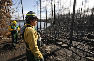
 Carl Skustad of the U.S. Forest Service surveyed the fire damage near campsite 7 on Lake Three, charred by the Pagami Creek fire. in the BWCA. (photo by David Joles) |
based partly on a news article in the Star Tribune
U.S. Forest Service officials took members of the news media on a paddling tour through the Boundary Waters Canoe Area Wilderness last Wednesday, to show them the effects of the Pagami Creek Fire. The burn pattern is called a mosaic, with some places charred and others not.
While the fire is comparable in size to the Ham Lake Fire of 2007, this fire did not burn across the North Country Trail. However, it did close the Kekekabic portion of the NCT because of the close proximity. The Kek is now open again.
The Pagami Creek fire burned across 51 BWCAW campsites, but only 5 are damaged enough that they are expected to be closed next year. Forest Service personnel will go through and cut down snags (leaning trees) which are a major danger after fires. Come spring, new growth will begin covering the black earth.
Over 1000 firefighters worked on the Pagami Creek fire, which is not yet quite 100% contained. The Pagami Creek fire area covered about 145 square miles, about 9.2 % of the entire BWCA. It burned down one structure -- a remote Minnesota DNR cabin.
 This segment is in the Kekekabic Trail Guide
 See Kekekabic Trail


No comments:
Post a Comment