Notice: I've taken a part-time job, and it's definitely affecting my blogging time. I'll continue to add content here as often as possible. Pertinent guest posts are always welcome.

-

Saturday, October 29, 2011

Transportation Enhancements Still Under Fire


a news release of Rails-to-Trails Conservancy

Transportation Enhancement Funds are meant to be applied to other forms of transportation than highways. These funds have benefited the North Country Trail in certain places where we follow urban pathways, or to provide pedestrian walkways on bridges. Although TE funds will never be a big portion of North Country Trail funding, this source of cash had been critical in building the country's multi-use trail system.

In his Senate Amendment 821, Senator Rand Paul (Ky.) is trying to force us to choose between safe bridges and safe places to walk and bike in our communities.

See RTC Vice President of Program Kevin Mills discussing in the video why we need your support:

Choosing between bridges and safe walking and bicycling is a false choice.

In truth, most states already have funds that they could use for bridge repair, but that instead go for new roadways. Further, last year, states sent back $530 million in unspent bridge funds.

It’s shameful and disingenuous to claim to be promoting safety by pushing to cut funds for trails, walking and bicycling when 47,000 cyclists and pedestrians have died during the past decade.

Sen. Paul’s is the third attack on TE in a single month.

In late September, Senator Tom Coburn (Okla.) attempted to eliminate dedicated funding for this crucial program. Working through a broad coalition, supported of trails joined together to send more than 50,000 messages to your senators, asking them to support TE.

Unfortunately, some in Congress believe that if they keep hammering away at a wildly popular, low-cost, highly efficient program, we’ll finally get tired and let them destroy a 20-year legacy of building a balanced transportation system.


See Rails to Trails
Monday, October 24, 2011

Kekekabic Trail Reopens After Pagami Creek Fire


aftermath of Pagami Creek Fire
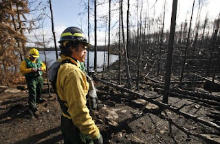
Carl Skustad of the U.S. Forest Service surveyed the fire damage near campsite 7 on Lake Three, charred by the Pagami Creek fire. in the BWCA. (photo by David Joles)

based partly on a news article in the Star Tribune

U.S. Forest Service officials took members of the news media on a paddling tour through the Boundary Waters Canoe Area Wilderness last Wednesday, to show them the effects of the Pagami Creek Fire. The burn pattern is called a mosaic, with some places charred and others not.

While the fire is comparable in size to the Ham Lake Fire of 2007, this fire did not burn across the North Country Trail. However, it did close the Kekekabic portion of the NCT because of the close proximity. The Kek is now open again.

The Pagami Creek fire burned across 51 BWCAW campsites, but only 5 are damaged enough that they are expected to be closed next year. Forest Service personnel will go through and cut down snags (leaning trees) which are a major danger after fires. Come spring, new growth will begin covering the black earth.

Over 1000 firefighters worked on the Pagami Creek fire, which is not yet quite 100% contained. The Pagami Creek fire area covered about 145 square miles, about 9.2 % of the entire BWCA. It burned down one structure -- a remote Minnesota DNR cabin.

This segment is in the Kekekabic Trail Guide

See Kekekabic Trail

Wednesday, October 19, 2011

New National Park Service NCNST Superintendent Named


Wade Vagias
Wade Vagias in 2004 (photo from the Pittsburgh Post-Gazette )

from a news release of the National Park Service

Wade Vagias, currently the acting Management Assistant at Yellowstone National Park (NP) in Wyoming, has been named the new Superintendent for Ice Age and North Country National Scenic Trails (NST), headquartered in Madison, Wisc. He replaces Tom Gilbert, who retired from Federal service in May. Vagias will take this new position effective January 1, 2012.

“Wade’s strong partnership skill set, including his extensive work with varied stakeholder groups within and outside the Federal government, makes him an excellent choice to lead these two premiere trail systems,” said National Park Service (NPS) Midwest Regional Director Michael T. Reynolds. “We look forward to having Wade as part of our Midwest Region management team.”

Vagias has been on a detail assignment as Management Assistant at Yellowstone NP since April, focusing his efforts primarily on the park’s Winter Use Plan/Environmental Impact Statement. His home office is the Wilderness Stewardship Division in the NPS Headquarters in Washington, D.C., where his work focuses primarily on wilderness stewardship planning. Vagias serves as Co-Chair of the NPS Wilderness Character Integration Team, an 18-member team from across the Service seeking ways to integrate wilderness character into NPS planning, monitoring, and management, as guest editor for the forthcoming Wilderness Edition of Park Science, and oversees the Wilderness Fellows Program.

Prior to working for the NPS, Vagias was a post-doctoral fellow in the Department of Parks, Recreation, and Tourism Management at Clemson University in South Carolina. He earned his Doctor of Philosophy in Parks, Recreation, and Tourism Management at Clemson, where his dissertation evaluated the Leave No Trace visitor education program in three NPS units. Vagias’ professional experience includes faculty appointments with Lock Haven University and Butler County Community College, both in Pennsylvania; river ranger with the Bureau of Land Management in Maupin, Ore.; raft guide with the Nantahala Outdoor Center in Long Creek, S.C.; mountain operations at Snowbird Ski Resort in Utah; as well as research projects for the National Audubon Society and the NPS.

“I am both humbled and honored by the opportunity to work with the staff of the Ice Age and North Country Trails and the many partners that work collaboratively with the NPS to help meet the mission of these two partnership parks,” Vagias said. “Trails connect us to the land and to each other, and I look forward to strengthening these connections.”

Vagias, his wife, Jenna, their daughter, Brooke, and chocolate lab, Charlie, will be relocating to Madison this winter and look forward to integrating into the Madison community and dusting off their cross-country skis.


See North Country Trail Association
See Ordinary People, Extraordinary Deeds for a 2004 story about Vagias


Sunday, October 16, 2011

Crown Point Bridge Update

Crown Point Bridge arch
new Crown Point Bridge arch span being put in place (photo from NY DOT)

compiled from several sources

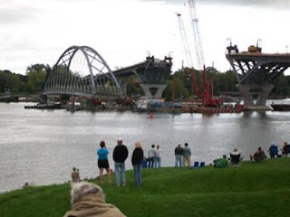
The Crown Point, NY bridge across Lake Champlain to Vermont has been the eastern terminus of the North Country Trail. In Dec 2009, the old bridge was demolished, and the estimated date for reopening of the new bridge has been October 2011.

Although progress has been steady, the bridge is not open, and the New York DOT has declined to give a final date for opening. In light of this, the Lake Champlain Bridge Community group has scheduled a celebration for May 19, 20, 2012.

The new bridge is important to the NCT because of the expected connection with the Appalachian Trail through Vermont. Hikers continuing east would need to cross the bridge, and the new bridge does, indeed, have a pedestrian walkway.

At this point, the bridge looks very close to completion. The approaches were completed first, and the central arch was brought to the site, complete, by barge and then lifted into place on August 26, 2011. But there is work to be done on the surface and other details which have postponed the opening.


See New York DOT Bridge updates
See Lake Champlain Bridge Community
See Crown Point Bridge Demolition
See Vermont Connection Seriously Considered


Friday, October 14, 2011

A 30 Hour Thru-Hike of the Border Route

from Gear Junkie

In September 2011, The Gear Junkie and friends attempted a 24-hour thru-hike of the Border Route Trail, on the Minnesota Arrowhead section of the NCTA. They didn't quite make that goal, but came close, covering the 68 rugged miles in just over 30 hours.

It's my opinion that hiking shouldn't be about simply how fast you can cover the ground. Nevertheless, this type of adventure will appeal to many people.

Fast & Light on the Border Route Trail, Minnesota - Brought to you by Timberland™ from Gear Junkie on Vimeo.


See Border Route Trail

Wednesday, October 12, 2011

Florence Hedeen Honored by Northwest Minnesota Foundation


Florence Hedeent
Florence Hedeen- taken on a hike (photo by Lyle Bialk)

based on a news article in thePark Rapids Enterprise

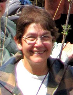
Anyone who has attended NCTA annual conferences knows Florence Hedeen, and any NCTA volunteer in Minnesota knows that she works tirelessly for the North Country Trail. Her dedication to this, and other, causes has now be noted by the Northwest Minnesota Foundation. She is one of three recipients of their 25th Anniversary excellence awards. Florence was "selected for strong leadership and for continually enhancing the quality" of places she lives and works.

Florence and her husband, Carter, live in Park Rapids, Minnesota.

She is active with the Northwest Minnesota Women’s Fund, serving on the advisory committee for 10 years and also served as the chairperson. She helped restart the Park Rapids League of Women Voters and was elected to the state board. Her work on increasing League membership in Minnesota resulted in her nomination to become a Ruth S. Shur Fellow in 2009 and she was among the first class of 12 national coaches serving state and local Leagues.

Just in case that isn't enough to keep Florence busy, she is also a member of the local school board.

Florence is living proof that if you want something done, you should ask a busy person. Her energy always amazes us, and we salute her for this honor.


See Itasca Moraine Chapter of the NCTA


Monday, October 10, 2011

Finger Lakes Trail Website Offers Interactive Map

elevation example map for Finger Lakes Trail
example of an elevation profile

from the Finger Lakes Trail Conference

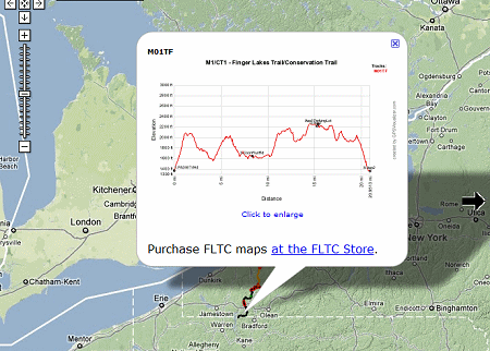
An interactive map for the whole Finger Lakes Trail system of ~950 miles is now online at www.fingerlakestrail.org.

You can zoom in and pan the map. Zooming in twice shows waypoints for trailhead parking, shelters, campsites (including primitive), and hunting closures (red flag waypoints). Clicking on a waypoint brings up more info about it (closure dates for hunting closures).

Clicking on an FLT copyright symbol gives the last revision date for a map and gives a link to the FLT store.

Clicking on a track (main or branch) brings up an elevation profile for that map; this can be enlarged.

Creating this map for over 950 miles of trail is an amazing accomplishment. It will be a great aid to planning hikes. It should be noted that there is much more detailed information on the printed maps, and one should not attempt a long hike without purchasing those.


This refers to the entire Finger Lakes Trail System in NY

See Finger Lakes Trail Conference

Saturday, October 8, 2011

New Kekekabic Trail Guide Issued in 2011

Terry Bernhardt with Kekekabic Trail Guide
Terry Bernhardt with the new Kek Guidebook (photo from NCTA)

based on a post on the North Country Trail Association blog

In April of this year, a new and updated guide to the Kekeabic Trail section of the NCT was quietly introduced. The original guidebook was issued in 1996 and needed serious overhauling. Both the big blowdown of 1999 and several fires have impacted the trail since that time.

A Field Grant from the NCTA was used to fund the book. The project was led by Terry Bernhardt (former KTC President), Mark Stange (current KTC President), the author, and NCTA’s Matt Rowbotham who produced the trail maps.

The Kekekabic Trail is the western section of the top portion of the Minnesota Arrowhead. This part of the trail is within the Boundary Waters Canoe Area Wilderness.

This segment is in the new Kekekabic Trail Guide

See Kekekabic Trail Club


Thursday, October 6, 2011

New Bridge Near Napoleon, Ohio

bridge on Buckeye Trail
completed Buckeye/NCT bridge (photo by Bob Morrison)

based on a blog post of the Henry County Parks

With the dedication and enthusiasm of local volunteers, on July 23, 2011, the new bridge was opened on the Buckeye Trail/North Country Trail in northwest Ohio. This bridge is about a quarter-mile east of the Henry County Hospital near Napoleon.

With the completion of this bridge, the entire trail in Henry County is clear. Read more, and see more pictures at New Bridge Built on the Buckeye Trail / North Country Trail


This segment is on Buckeye map Defiance section

See Buckeye Trail


Tuesday, October 4, 2011

Ferrying Materials for Wisconsin Puncheon

lumber carried on canoes
canoe ferrying construction material (photo by Bill Menke)

excerpted from NCTA blog by Bill Menke

We had a very productive (but also very strenuous) outing last week. For several years we puzzled over how to get our puncheon materials into the trail segment that is on the north side of the St. Croix River and between the Gordon Dam ATV Trail and West Mail Road (map), Because of the flat rocks that we used to construct a walking surface on the upland portions, our powerwagon would have bounced around and literally destroyed the work we had already done while we were waiting for the WI-DNR to issue the permits we needed to construct the wetland structures.

We considered a helicopter contract (too expensive at a minimum $100,000), and draft horses, snowmobiles, and ATVs dragging or trailering the materials through the woods. All of these latter three modes would have also destroyed the trail. We also thought about boating the materials down the river from Gordon Dam but there are too many shallow places which would prevent passage with a loaded boat.

Finally, crew member Phil Anderson came up with the idea of working them across the river with two canoes that were fastened together to form a carrying platform.

This was a tremendous transportation job. All in all, we moved over 100 4x6x16 foot beams, 100 telephone pole sills (5 feet long), and almost 1900 deck boards (3 feet long) across the river. All that is left of the south side for next month is about 15 sills and 15 beams and these are all already at the river edge or at the top of the bluff.

For lots more pictures and more explanation see the NCTA blog- link below.

This segment is on NCTA map WI-02

See Rover’s unique puncheon material canoe ferry operation


Sunday, October 2, 2011

Bruce Matthews Interviewed on "A Watershed Moment"

Bruce Matthews
Bruce Matthews, Executive Director NCTA (photo by jhy)

excerpted from the West Michigan Environmental Action Council blog

On the September 27th episode of the West Michigan Environmental Action Council's "A Watershed Moment," Bruce Matthews was interviewed about the North Country Trail. “A Watershed Moment” is a weekly radio program focused on environmental news and happenings in West Michigan, plus solutions for living a greener life.

Matthews is the Executive Director of the North Country Trail Association. He gives an overview of what and where the trail is, and urges more people to try it out. You can listen to the entire interview at WMEAC. Many audio formats are available.

See North Country Trail Association

The North Country Trail News blog is happy to welcome a new sponsor, Black Friday Deals. See the green ad box in the right sidebar. They offer lots of outdoor products, including many for hunting and fishing. Although those are not the primary focus of the NCT, we know that lots of sportsmen and women use the trail. If you browse their sales lists you'll find lots of items for camping or other outdoor pursuits, at a discount.