Notice: I've taken a part-time job, and it's definitely affecting my blogging time. I'll continue to add content here as often as possible. Pertinent guest posts are always welcome.

-

Tuesday, December 30, 2008

Wacky for Waymarking Finds the NCT

Quilt Barn
Quilt Barn seen from the BT/NCT
from the Wacky for Waymarking blog. Used with permission.

Marine Biologist is a couple and our name is a combination of our occupations. Rodney is a retired Marine. Sandy is a Wildlife Biologist. The Biologist is wacky for waymarking. The Marine... not so much, but he often goes along for the ride. Join us on our waymarking (and geocaching) adventures!

Dec 17, 2008
Once we made it into Ohio, we decided to make a short detour to the Salt Fork State Park to see if we could spot a North Country Trail marker. The trail runs through this park and overlaps with the Buckeye Trail. We spotted markers for the Buckeye Trail, but no markings specifically for the North Country Trail. I guess we'll just have to keep looking. Anyway, before leaving this state park, white things started falling from the sky. Aack! Snow! We don't have that in Florida. Oh boy.

Dec 27, 2008
We began our journey home at about noon today. We decided to again try to avoid the interstate highways and take a meandering, scenic route. We spotted quite a few Painted Quilt Barns on our journey but only stopped at four of them, three in Ohio and one in Kentucky. They were fun to look for as we wandered along.

NCT Marker Fort Hill Ohio
NCT Marker at Fort Hill
Ohio, and the Marine
We made a planned stop at the Fort Hill State Memorial in Hillsboro, Ohio, to once again search for a North Country Trail sign. We knew the trail passed through this park jointly with the Buckeye Trail, but weren't sure if it would be marked as such. As luck would have it, it was! We would love to have hiked on the trail for a bit to view the 1 1/2-mile long Hopewell Indian earthwork hilltop enclosure, but all the trails were closed for the hunting season. What we did see of the park, though, was very nice and we'd love to make a return visit.

Lost on Kekekabic Trail – Update

hikers rescued from the Kekekabic trail
The rescued women were flown by
helicopter out of the Boundary Waters
Canoe Area Wilderness to Ely. photo CBS
a news release of Boundary Waters Advisory Committee

In October, two hikers from Duluth, Minnesota, were rescued after being lost for several days on the Boundary Waters Canoe Area (BWCA) Kekekabic Trail. Shortly after that, the Boundary Waters Advisory Committee (BWA Committee) offered help to the US Forest Service with trail maintenance.

In November, to identify the troublesome sections of the trail, Martin Kubik, Founder of the BWA Committee (and of the Kekekabic Trail Club) backpacked and cataloged the 42 mile trail during a solo, three day through-hike. “The Kekekabic represents a challenge even to most expert hikers. The burned area, about 13 miles long, has many segments where the trail simply disappears from one spot to another. Because the trail is unmarked, there is no way for hikers to reconnect the path between more visible segments. This increases a visitor’s risk, because they have no idea when and how many times this will happen, and whether they will be able to stay on trail to complete the journey ,” said Kubik.

The BWA Committee offered to update the guide to the Kekekabic Trail in a meeting with the US Forest Service two years ago. The Forest Service officials dismissed the idea, contending that guide would be inappropriate for a trail in wilderness area. USFS officials have also turned down suggestions to mark the trail. Kubik responds that “with hikers getting lost on the Kek, and the rescue costs mounting to tens of thousands of dollars, we hope that will change. We need to find a reasonable compromise that meets the wilderness criteria while permitting the backpackers to enjoy the wilderness and stay safe.”

The BWA Committee plans to cooperate with the USFS to develop a plan to revitalize the Kekekabic Trail. Without such a plan, the trail will continue to deterioriate, and in the interest of hiker safety, may need to be closed, as it was in 1980. The Kekekabic Trail was designated a Community Millennium Trail in 2000 and it is expected to become a part of the North Country Trail in 2009.

The BWA Committee is a non-profit, grass roots organization that advocates restoration of historic, intrinsically beautiful hiking trails in the BWCA wilderness. The BWA Committee volunteers have adopted the Eagle Mountain/Brule Lake trail and have cleared segments of the Snowbank and Kekekabic Trails this year.

Photo essays showing the trail and volunteers in action are at Smugmug

Read about the women who were lost and rescued at WCCO.com

Sunday, December 28, 2008

North Country Trail Hikers Program

NCT HIkers Logo
from the North Country Trail Hikers Chapter

At the General Membership Meeting scheduled for Tuesday, January 13, Carol Fullsher, Director of Recreation Development, Lake Superior Community Partnership to agreed to come and speak to us. Carol will share a PowerPoint presentation on the Iron Ore Heritage Trail, its current progress and plans for the future. The program ends with Q&A session.

The meeting will be at 7:00 pm at 1830 Altamont St. in Marquette, Michigan.


Saturday, December 27, 2008

W. K. Kellogg Experimental Forest - Segment Spotlight

Kellogg Forest Experimental Station
from the Chief Noonday Chapter 4th Q 2008 newsletter

One of the Kalamazoo County segments of the North Country Trail crosses the W. K. Kellogg Experimental Forest, one of 14 Agriculture Experiment Stations of Michigan State University. See Kellogg Experimental Forest for more information on the work done at these stations.

The Forest hosts several open houses each year, including the maple syrup demonstration in the spring. Visitors are welcome to jog, bicycle, hike, horseback ride (bring your own horse), walk your dog, trout fish, bow hunt (you must sign in at the office), and cross country ski.

This segment of trail is 2.4 miles long, and shares portions of several wooded loop trails which can be enjoyed on this property. There is convenient parking (as well as picnic tables) at the main facilities on 42nd Street, about a mile south of M-89. This location also features the covered bridge, which can be seen from
the parking area.

This segment begins from the north on M-89, about 0.3 miles east of 42nd Street. Continuing north, our trail follows M-89 west for 0.7 miles before entering the Cheff property.

From the south end of this segment, the trail crosses the Sackett property to the south for 0.5 miles, then follows EF Avenue to the west for 0.2 miles, before heading south on the Hutchinson property for 1.5 miles to the trailhead on Augusta Drive.

Friday, December 26, 2008

Michigan Archivist Noting North Country Trail

from the Anecdotal Archivist Blog

We have been steadily moving forward with our launch of Seeking Michigan. If you have not heard me talk about this, it is a new joint effort with the Library of Michigan. It appears that we are slated to launch on February 1, 2009. We will hit you with a news blast nearer that date.

One component of the site is “Look.” This will feature fun and interesting stories about Michigan’s past and present. A team of twenty-seven history professionals will be adding content. We hope to open it up to the public so you too can share your stories and photographs.

Processing:
Archivist Bob Garrett is processing the North Country Trail Collection (MS 2008-28). This collection documents the life of Peter Wolfe, advocate for the NCT and one of the first to walk the entire length of the trail.

NCT Progress in Western Minnesota

Laurentian Lakes Chapter
This group of volunteer laborers
takes a break on a bridge they built
along the North Country Scenic National Trail
in Becker County.
from Detroit Lakes Online, "Little by little, walking trail coming together," by Pippi Mayfield, Dec 24, 2008

After more than 25 years of clearing and constructing, the North Country National Scenic Trail has entered Becker County.

“It’s very much a work in progress,” said Matthew Davis, regional trail coordinator for Minnesota and North Dakota.

The trail through Becker County this far has been on state land, so the association hasn’t had to worry much about acquiring private land. The association has been able to work with the Minnesota Department of Natural Resources and the county for land... more

Wednesday, December 24, 2008

Birch Leafminer Controlled in Northeast

birch leafminer damage
photo by E. Bradford Walker, Vermont Department
of Forests, Parks & Recreation
excerpts from a news release of the University of Rhode Island

The United States has been under assault for decades by a wide variety of alien plants and animals, and it is not often that one of these aliens faces a counterpunch. But in a collaborative project with several other institutions, the University of Rhode Island has scored a knockout.

The birch leafminer, an insect pest that regularly disfigures birch trees, has been virtually eradicated in the Northeast. And the credit goes to entomologists from URI and other institutions who successfully introduced a biological control agent.

"Birch leafminers are no longer a pest in the Northeast," said Richard Casagrande, URI professor of plant sciences. The program consisted of introducing a natural enemy of the birch leafminer, a parasitoid called Lathrolestes nigricollis, which was brought to the U.S. from Europe where it effectively controls the birch leafminer.

Now the same can be said for Rhode Island, Massachusetts, Connecticut, New York, Pennsylvania and northern New Jersey. The URI scientists recently coordinated a survey that has documented complete control of this pest in these states.

According to scientists, the birch leafminer arrived in the U.S. in 1923, probably in a shipment of plant material sent to Connecticut. From there it spread throughout the Northeast and into the Midwest. In the 1970s, Roger Fuester and colleagues at the Delaware Beneficial Insects Rearing Lab introduced several European parasitoids to fight the pest.

The birch leafminer is not a fatal pest to birches. It disfigures the trees by mining within the leaves, and since birches are often used for landscaping, the effect became an aesthetic issue. Birches do have a fatal pest—the bronze birch borer – which can kill white-bark birches very quickly, but no biocontrol has been found for this native pest.

"The birch leafminer program is a good example of the results of a coordinated, long-term approach to classical biological control," Casagrande said. "We're seeing similar success with programs for purple loosestrife, cypress spurge, mile-a-minute weed, and perhaps, lily leaf beetle, but as you can see, it takes time— 34 years in this case for complete control."

Monday, December 22, 2008

Kekekabic Trail Clearing Dec 13, 2008

from Martin Kubik, see all the pictures at BWAC on Smugmug

BWA Committee trail crew members met at the departure point on Snowbank Lake public landing. As on many trips, enthusiasm ran high early in the day. First, we conducted a map and compass training session.

A Knee Wrecker
a knee wrecker
First, a "knee wrecker". A knee wrecker is any treefall either high off the ground and/or so thick that a backpacker has to twist his/her body when climbing over. This type of strain can lead to knee injuries. Our job is to minimize the risk to hikers but cutting down treefalls like these. The Forest Service supplied cross-cut saws.

We passed through some areas of "backpacker's nightmare." Without tread and/or marking the clear cuts would be extremely difficult (read: "impossible") to navigate. Thankfully, flagging pointed the way.

clear winter trail
sometimes the trail is easy to see in winter
Some segments of trail are very distinct and easy to follow in the winter. Some times the trail is much more obscure. After the day's work the crew headed out. It took us 2.5 hours of traveling in the dark to reach the public landing on Snowbank. We took the Kubik "shortcut" to Parent Lake, and aiming-off bearing to Snowbank portage in a blinding snow storm. The crew performed admirably under duress and we reached the landing at 7 pm.

Sunday, December 21, 2008

Heel Pain of Plantar Fasciitis Can Be Eliminated

a news release of the Radiological Society of North America

Combining an ultrasound-guided technique with steroid injection is 95 percent effective at relieving the common and painful foot problem called plantar fasciitis, according to a study presented today at the annual meeting of the Radiological Society of North America (RSNA).

"There is no widely accepted therapy or standard of care for patients when first-line treatments fail to relieve the pain of plantar fasciitis," said the study's lead author, Luca M. Sconfienza, M.D., from Italy's University of Genoa. "Our new technique is an effective, one-time outpatient procedure."

Plantar fasciitis, the most common cause of heel pain, is an inflammation of the connective tissue called the plantar fascia that runs along the bottom of the foot, from the heel to the ball of the foot. The condition accounts for 11 percent to 15 percent of all foot symptoms requiring professional care and affects one million people annually in the U.S.

Conservative treatments, which may take up to a year to be effective, include rest, exercises to stretch the fascia, night splints and arch supports.

When the condition does not respond to conservative treatments, patients may opt for shockwave therapy, in which sound waves are directed at the area of heel pain to stimulate healing. Shockwave therapy is painful, requires multiple treatments and is not always effective. Complications may include bruising, swelling, pain, numbness or tingling and rupture of the plantar fascia. In the most severe cases of plantar fasciitis, patients may undergo invasive surgery to detach the fascia from the heel bone.

For this study, Dr. Sconfienza and colleagues used a new ultrasound-guided technique, along with steroid injection, on 44 patients with plantar fasciitis that was unresponsive to conservative treatments.

After injection of a small amount of anesthesia, the anesthetic needle is used to repeatedly puncture the site where the patient feels the pain. This technique is known as dry-needling. Dry-needling creates a small amount of local bleeding that helps to heal the fasciitis. Lastly, a steroid is injected around the fascia to eliminate the inflammation and pain. The technique is performed with ultrasound guidance to improve accuracy and to avoid injecting the steroids directly into the plantar fascia, which could result in rupture.

After the 15-minute procedure, symptoms disappeared for 42 of the study's 44 patients (95 percent) within three weeks.

"This therapy is quicker, easier, less painful and less expensive than shockwave therapy," Dr. Sconfienza said. "In cases of mild plantar fasciitis, patients should first try noninvasive solutions before any other treatments. But when pain becomes annoying and affects the activities of daily living, dry-needling with steroid injection is a viable option."

Saturday, December 20, 2008

A Hike In the Woods Proven Restorative

a news release of the Association for Psychological Science

Not that it is any real surprise to those of us who love to walk in the woods, but now research proves that "A Walk In The Park A Day Keeps Mental Fatigue Away."

If you spend the majority of your time among stores, restaurants and skyscrapers, it may be time to trade in your stilettos for some hiking boots. A new study in Psychological Science, a journal of the Association for Psychological Science, reveals that spending time in nature may be more beneficial for mental processes than being in urban environments.

Psychologists Marc G. Berman, John Jonides, and Stephen Kaplan from the University of Michigan designed two experiments to test how interactions with nature and urban environments would affect attention and memory processes. First, a group of volunteers completed a task designed to challenge memory and attention. The volunteers then took a walk in either a park or in downtown Ann Arbor. After the walk, volunteers returned to the lab and were retested on the task. In the second experiment, after volunteers completed the task, instead of going out for a walk, they simply viewed either nature photographs or photographs of urban environments and then repeated the task.

The results were quite interesting. In the first experiment, performance on the memory and attention task greatly improved following the walk in the park, but did not improve for volunteers who walked downtown. And it is not just being outside that is beneficial for mental functions—the group who viewed the nature photographs performed much better on the retest than the group who looked at city scenes.

The authors suggest that urban environments provide a relatively complex and often confusing pattern of stimulation, which requires effort to sort out and interpret. Natural environments, by contrast, offer a more coherent (and often more aesthetic) pattern of stimulation that, far from requiring effort, are often experienced as restful. Thus being in the context of nature is effortless, permitting us to replenish our capacity to attend and thus having a restorative effect on our mental abilities.

Grand Traverse Jan Program

Grand Traverse Chapter logo
from the Grand Traverse Hiking Club Chapter of the NCTA

Tuesday, January 20, 2009
at 7 PM in Classrooms A & B at MCHC

Hiking in Torres del Paine (Chilean Patagonia) with Nancy Fleming and Bill Schafer Torres del Paine National Park is a Chilean National Park filled with ountains, glaciers, lakes and rivers. Don’t miss this opportunity to hear about their trip to this isolated wonderland.

Friday, December 19, 2008

Buckeye Trail / NCT Makes Robin Smile

Buckeye Trail


from the blogs Bogs of Ohio and Bountiful Healing by Robin. Various entries, used with permission


10 things that make me smile

#1: Walks and hikes in the woods

Buckeye Trail

Buckeye Trail
"The clearest way into the Universe is through a forest wilderness." ~ John Muir

We woke up to a clear, cold day, the sun shining like crazy. The temperature was 20 degrees (F). M and I decided to take a hike on the small piece of the Buckeye Trail near where we live.

This is my favorite kind of hiking weather. I love how blue the sky looks in the winter, and how crisp and fresh the air feels and smells.

It was a good way to start out the month of December, before things get messy (as they will tonight with a snow, sleet, and rain mix).

Thursday, December 18, 2008

NPS Releases Proposed Change to Bike Use on Trails

a news release of American Hiking Society

Today, the National Park Service (NPS) released a proposed rule change to amend current regulations for designating bicycle use on NPS lands. American Hiking Society remains vigilant on behalf of our membership and partners and is analyzing the proposed changes to safeguard your hiking experience. We are committed to ensuring that trail use decision making processes are equitable, consistent with agency policies and offer transparent stakeholder involvement. Please watch for additional alerts.


American Hiking Society encourages all hikers and trails enthusiasts to get involved, become informed, and participate in public processes that impact the National Parks where we love to hike. We urge those of you who care about trails in our National Parks to take advantage of the opportunities for public comment to which you are entitled. Visit HERE to read the National Park Service proposed ruling and submit your comments within the next 60 days. Your voice can ensure that decisions determining trail use in our National Parks are consistently and clearly applied.


On November 3rd, American Hiking Society alerted our members and partners that this ruling was expected, and that it would be released without sufficient efforts to educate and engage all trail users in the process of designating trail uses in our treasured National Parks. Within days, hundreds of hikers responded to our call to action, urging the Secretary of the Interior to engage all trail users in their rule-making process.


See Executive Order Could Open National Parks to Mountain Bikes

See American Hiking Society Considers a Plan


Vaccine for West Nile on the Horizon?

from a news release of the University of Queensland

Research conducted at The University of Queensland could contribute to the development of a vaccine and cure for West Nile virus and Dengue fever.

Led by Associate Professor Alexander Khromykh, a team of researchers from UQ's School of Molecular and Microbial Sciences identified a novel characteristic of the virus family to which these diseases belong.

This family, the flaviviruses, produces a small molecule. One of its functions is to control the response of the host to the viral infection. The molecule itself is part of the genetic material of the virus, and is labeled sfRNA.

The researchers stated that all flaviviruses tested thus far have contained the sfRNA. This means that targeting that specific part with an antiviral therapy may be effective for the whole range of flaviviruses.

By using reverse genetic engineering they were able to generate viruses that do not produce this sfRNA. The viruses that were missing the sfRNA were no longer able to kill their hosts or elicit disease symptoms. However, the engineered viruses did trigger the antiviral immune response in the host. This means that the body would create its own protection against all flaviviruses without contracting the disease.

These tests were conducted with mice. "The knowledge obtained from our studies with West Nile virus should be readily applicable for designing anti-viral drugs and engineering similar vaccine candidates for other medically important flaviviruses," said team leader Associate Professor Alexander Khromykh.

The study will be published in the December issue of the prestigious journal from Cell Press, Cell Host & Microbe.

Wednesday, December 17, 2008

Canastota NY Negotiates Agreement with Snowmobilers

based on a news story of CNYLink.com, "Canastota: Agreement made with snowmobile club", by Margo Frink, Dec 16, 2008

A portion of the Link Trail in central New York state is a key connection between the Finger Lakes Trail and the Adirondacks. In the village of Canastota a segment of the trail was open to snowmobiles and thus could not be certified.

Now the village board of Canastota has entered into a Landowner Easement Agreement with the Tri-Valley Riders Inc. snowmobile club.

The section of trail in question runs parallel and left of the Link Trail just north of James Street and continues toward the buffer zone between the Industrial Park and Port Street. The Link Trail, which is part of the North Country Trail, runs south of the railroad tracks.

A train derailment in January near this area resulted in a donation by CSX to pave the trail. $30,000 was given to the village for that purpose.

"Snowmobilers are asked to stay off the paved surface," said Canastota Police Chief James Zophy. Zophy said the speed limit set in that area is 25 mph, and the Tri-Valley Riders will erect signs along the route. The agreement is contingent upon the club accepting these restrictions. The club has agreed to mark the right-of-way and maintain it year-round.

This portion of the North Country Trail is maintained by the Central New York Chapter of the NCTA.

Tuesday, December 16, 2008

So You Think Your Food is Safe?

This photo essay is making the email rounds, but it seems really appropriate for hikers to see. Lest you think that bears are not smart or agile, this will give you something to think about next time you hang your food in the woods. And this is why I much prefer to be far away from areas where the bears have become accustomed to people. Meanwhile, have a good chuckle!
Bear at Bird Feeder view 1


Bear at Bird Feeder view 2


Bear at Bird Feeder view 3


Bear at Bird Feeder view 4


Monday, December 15, 2008

December Hiking on the SHT

Lake Superior from the SHT
photo by Kurt Papke
submitted by Kurt Papke, hiking Dec 8-10, 2008

The Trail
Hiked from Beaver Bay parking lot to Penn Cr campsite and back the next day to Beaver South campsite. Hadn't been on this section in some time and never camped there. The trail had 4-5" inches of fresh powder. No tracks in the snow but the deer and mine. Started out with snowshoes, but quickly strapped these to my pack as there wasn't that much snow and this trail section is pretty rocky.

This is a pretty section of trail. Lots of scenic views, and lots of pine trees in the "green tunnel" that were decorated for the season with fresh snow. It was prettier on Tuesday with the sun shining.

The trail is very quiet in the winter: no grouse drumming, no crickets or frogs at night, etc. Just the sound of buzzing ATV's...

This is not a great trail section for snowshoeing - too rocky and lots of steep stair sections. It was fun to clamber around in though, but I was really glad I had my trekking poles.

The Penn Creek campsite is ideal for winter camping, but I would think it would be really buggy in the summer. It is in a low area, making it very protected from wind. Very pretty.

The Beaver South campsite is great for hammocks! It is also pretty in the winter, and the pine trees keep it very sheltered. Nothing like the train blowing their whistle at 1AM... This campsite is right on the river, but it was impossible to fetch water as the open spots were all in the middle of the river and I didn't trust the ice. I stayed here on night #2 because the last weather forecast I heard before hitting the trail was for -10F that night, and I wanted to be close enough to my car to bail out in case of problems. These two campsites on the Beaver River are great for this - 15 minute walk from the parking lot, on the beautiful river and very pretty sites.
thermometer at zero
note the temperature
photo by Kurt Papke


The Weather
Started out at 15F at noon on Monday and went down from there... Fortunately, there was very little wind except Monday night, so the wind chill wasn't too bad. Monday night got down to zero, Tuesday night down to -2 or so. I was plenty warm while hiking, in fact my biggest challenge was overheating. I was plenty warm at night except for a brief period Wednesday at about 5:30AM when my back got a little chilled. I was worried about staying warm in camp, but I had plenty of warm clothes and fared pretty well.

The Gear
The hammock worked well - the hardest part was staking out the tarp with the frozen ground and not enough snow for a snow anchor, but fortunately both campsites had a log or two close by that I could drag over and tie up to. My hammock tarp has only two tie-outs, so pretty simple.

I hate white gas stoves. I bought an MSR Simmerlite on sale this Fall, and I'm still not good at priming/warming this thing up. I also found out that BIC lighters don't work at 0F, but my REI stormproof matches worked like a champ.

Keeping water from freezing at these temps is a challenge. The Platy Insulator I'm testing for BGT froze up in the first 2 hours. I love the Montbell Permafrost jacket I'm testing - kept me unbelievably warm in camp, and also used it for insulation under the hammock at night.

Wore my Raichle waterproof hiking boots during the day - worked just fine even though they're not insulated. Carried bulky Itasca camp boots for the evenings, which have removable Thinsulate liners that kept my toes toasty at night.

My new REI Zenith 0F sleeping bag performed well. It has synthetic insulation so it is bulky, but its really warm and kept its warmth despite getting a little damp/icy from condensed perspiration.

I was glad I had a big pack - I'm testing a 90L High Sierra. It was packed full and I had stuff strapped all over the back. It wasn't that heavy, just under 50 lbs with 3 days of food and 3L of water, but winter stuff is bulky.

The Food
Not much new here except I did try Pop-tarts for the first time for breakfast. My wife works for General Mills and got some free Fiber One Strawberry tarts. They are quick and easy in the morning, and interestingly do not freeze at any temperature (unlike my protein bars...)

Lessons Learned
Winter backpacking is very different from the other seasons. I find I have to cut my mileage in half: daylight hours are short, the going is slow and strenuous in the snow, and it took me forever to break camp in the morning with melting snow for water and everything. I was very tired after two days - maybe from my body having to generate so much heat.

My biggest concern before the trip was keeping warm. This was a complete non-issue. What I need to learn to do better is regulate my temperature while hiking, taking off and putting on layers more dynamically. This was particularly an issue on this trail section as there are a lot of ups and downs which caused me to break a sweat. When I got into camp on Monday night my hair was frozen solid ice...

All that said, I think Winter is my new favorite backpacking season on the SHT. No bugs, no other hikers vying for the good campsites, and the air is so clear when the sun is out.

Lemme know if anyone is interested on going along on a future trip. I plan to do at least 1/month all Winter, though not all on the SHT. I want to hit the Porkies, and also want to try some of the Driftless areas in SE Minnesota along the Mississippi.

Sunday, December 14, 2008

Healthier Streams Near the NCT in the Manistee

trail work with geotextile
Volunteers install GeoWeb material to stabilize
and harden the trail surface.
from the USDA Forest Service "Success Stories"used with permission, by Dianne Berry, Dec 12, 2008

Several stream crossings on the Manistee National Forest are healthier thanks to joint efforts of Forest Service staff and North Country Trail Association (NCTA) volunteers. The West Michigan Chapter of the NCTA, with assistance from the Baldwin/White Cloud Ranger District, completed stream bank stabilization projects along two creeks using geotextiles and geocell materials to stabilize and harden the trail surface.

Intense recreation activities on sensitive topography led to substantial stream damage at a number of crossings along the North Country National Scenic Trail. Mountain biking and horse riding on steep slopes and sandy soils contributed to noticeable damage.

Along Michigan Creek, new trail rerouted a section of poorly located trail that was contributing to significant sedimentation and degradation of stream quality. Construction techniques included a locally unique application of geotextiles and geocells. Turn-style barriers and educational signage were installed at choke-points leading to the project area in order to deter illegal horse use and minimize the effect of mountain bike use on the trail.

Stabilization of an adjacent hillside with signs of damage from off-trail pedestrian traffic was completed as well, using biodegradable fiber water bars to slow water flow and filter suspended sediment. Additionally, a woven straw/ biodegradable net matrix was installed on the slope to stabilize surface soils and facilitate plant recruitment.

A variety of local, native seedlings were transplanted through the matrix to expedite the rehabilitation, add additional slope stability, and divert pedestrian traffic away from the slope. More than twenty Chapter volunteers contributed their time and labor to complete this project.

Along Tank Creek, an original section of trail was located within the sandy troughs of an abandoned railroad grade. Water and the resultant sediment would be trapped in the trough and funneled into the creek. A reroute of the trail out of the trough and up onto adjacent higher ground significantly reduced sedimentation of the creek.

Geotextiles and geocells were installed at the stream approach to help reduce the grade, stabilize the parent soils, and harden the trail surface. Biodegradable fiber water bars were also installed at strategic locations along the creek bank to slow water flow and filter suspended sediment. Barriers and additional educational signage are planned to deter illegal horse use that occurs along the trail and through the creek.

During these projects, volunteers overcame their doubts about the use of geocell materials.

"I received quite a few skeptical looks that first day when I pulled the geocell materials out of the truck," said Huron-Manistee National Forests' Trails Coordinator Chris Loudenslager. "But, upon completion of the project, more than a couple volunteers said I had made believers out of them."

Something to Say About the Northeast Mountains?

Waterman Fund logo

a news release of the Waterman Fund

Enter the 2009 Alpine Essay Contest

The Waterman Fund seeks the submission of essays about the mountains of the northeastern U.S. for its second annual Waterman Fund Alpine Essay Contest.

Guy and Laura Waterman spent a lifetime reflecting and writing on the Northeast's mountains. The Waterman Fund seeks to further their legacy through essays and stories that celebrate the spirit of the Northeast's mountains. We encourage the submission of essays that explore the relationship between the human spirit and that environment. Specifically, we are seeking personal essays about stewardship of wild places, whether through a scientific lens or an encounter with wildness.

Essays must be original works ranging from 2500 to 4000 words. The submission deadline is May 1, 2009. The winning piece will be published in Appalachiajournal, and the winning essayist will be awarded $2,000. In addition, the Waterman Fund may recognize one or more essays with honorable mention, awarding those winners with signed copies of the Waterman's companion volumes, Backwoods Ethics and Wilderness Ethics.

Writers who have not published a book or have not been published in a national magazine on the topic of the contest are eligible for participation.

see the complete rules

Saturday, December 13, 2008

Skiing at Bowman Lake

Bowman Lake
Bowman Lake is a small kettle hole
in the Manistee National Forest
by Joan H. Young

The Spirit of the Woods (SPW) North Country Trail Chapter enjoyed a ski/snowshoe outing at Bowman Lake today. Four people enjoyed the deep snow on a combination of the North Country Trail and Forest Service ski trails.

Bowman Lake trailhead parking lot is one of the few kept plowed in the winter by the Forest Service. The area is popular with local skiers, although the trails are not groomed. Bowman Lake is a small glacial kettle hole lake just a few yards off of the North Country Trail. Since the lake is not vehicle accessible it is a quiet spot, popular with backpackers and anglers.

There are four campsites with tent pads around the lake. The pads were installed in 2004 by the SPW Chapter and the Heckman family. The project was funded by a memorial in honor of Randall Heckman, a young man who loved hiking the trail.

Bowman Lake
crossing a small dry kettle
On this day, the snow was deep and unbroken except for an occasional deer that had passed ahead of us. We took turns breaking trail, and were considering taking a 2 mile loop. After an hour we were about half way around, and decided to take the easy way out and retrace our steps rather than continue to break new trail.

Some days everything just seems perfect. This was one of those days. The air was mild, light flakes of snow swirled through the woods. We walked just far enough to feel well-exercised, but not dead tired.

You should have been there! Of course you can make your own perfect North Country Trail adventure.

Friday, December 12, 2008

Allegheny National Forest Receives Friend of the Trail Award

Friend of the Trail Award Presentation
L-R:K. Klos of the NCTA chapter w/ ANF employees:
J.Langianese, R.Fallon, J.Vanselow,
L.Marten, T.Scardina, and R.Wetherell
from the USDA Forest Service "Success Stories" used with permission, by Lori Elmquist, Nov 11, 2008

The Allegheny National Forest (ANF) received a Friend of the Trail award from the North Country Trail Association (NCTA) for its leadership, partnership and staunch support of the North Country National Scenic Trail. At the annual NCTA conference Keith Klos, NCTA ANF chapter president, accepted the award on behalf of the Forest.

Klos later presented ANF Forest Supervisor Leanne Marten, Bradford District Ranger Tony Scardina and Marienville District Ranger Rob Fallon each with a clear diamond shaped award for their offices.

Karen Klos, ANF Chapter Organizer, nominated the Forest for the Friend of the Trail award.

"I nominated the ANF for the award, because of its employees' cooperative, positive and helpful attitudes, without their help we couldn't accomplish nearly as much as we have," Klos said.

The North Country Trail (NCT) is 4,600 miles long and travels through North Dakota, Minnesota, Wisconsin, Michigan, Ohio, New York and Pennsylvania. Of the 300 miles in Pennsylvania, approximately 96 are within the Forest boundary. The ANF Chapter, one of four NCTA Chapters in Pennsylvania, is responsible for building, maintaining and promoting the ANF section of the Trail. All of the NCT work is done by volunteers.

The ANF works closely with the Chapter to organize and provide volunteers to complete work on the Trail. This past summer, District Ranger Rob Fallon recruited a Student Conservation Association group to work on the Forest. The 10 high school students from the Pittsburgh and Boston area completed 2,791 linear feet of trail clearing, 100 feet of bench construction, 160 feet of puncheon construction and the construction of three rock culverts.

Spring fire season on the ANF turned rainy, so the Bear Paw Fire Crew from Montana that came to help with fire suppression used their time to clear almost a mile of trail.

"These men had great attitudes as well as excellent teamwork and safety standards," said Klos.

The ANF NCTA chapter also awarded a certificate of appreciation to ANF Recreation Manager Robert Wetherell for his continued sawyer training support. Wetherell initially pulled together the Trail's saw use policy. He also holds sawyer training at the NCTA's annual conference and twice throughout the year on Forest for various volunteer groups.

The Klos's said that they value the unique working relationship between their organization and the Forest.

"The ANF deserved the award, earned the award and needed the award to know how much we appreciate their help," Klos explained.

Each year the 96 miles of NCT within the Forest brings numerous visitors to the area. These visitors will continue to enjoy a premier footpath through the Allegheny National Forest thanks to the hard work and cooperation of the ANF and the ANF NCTA chapter.

Thursday, December 11, 2008

Kekekabic Trail Clearing Dec 6 2008

winter trail clearing
work crew after a productive day
from Martin Kubik, see all the pictures at BWAC on Smugmug

Saturday, December 6, 2008. Our crew is optimistic about the mission to clear near Bingshick Lake. At this point we are about 1/2 mile from the Gunflint trail head. Visible in winter, the trail is overgrown with raspberries in summer.

drying out
drying out after breaking
through the ice
I broke through ice near beaver lodge. Falling into icy water is a adrenalin rush you don't want to experience very often. Temperature? Somewhere around 10 deg F. This was deepest ever. I was in water up to just below the waist. My sorel boots filled with water. Next I pulled myself up by grabbing a frozen-in branch sticking out of the beaver lodge. I knew fire wood supply was plentiful at the Bingshick campsite and chose to hike. When we reached it, my pants were ice outside. Scenes from the movie Stalingrad where everyone dies from cold flashed in my mind. Remedy: Drinking hot jello that Art brought in a thermos and drying next to a emergency fire. Thank you guys! Surprisingly, we dried wet clothing in about one hour and were able to start clearing by noon.

It was quite apparent that no hikers passed through where the trail was obstructed by blowdowns. Backpackers bypass this segment by hiking on the ridge above and some have turned back unable to find the path. The obstacles were dispatched to sawdust. Trail is safe again for backpackers.


NOAA’s U.S. Winter Outlook for NCT Regions

temperature outlook map
a news release of NOAA

In announcing the 2008-2009 U.S. Winter Outlook for meteorological winter from December through February, forecasters at the NOAA Climate Prediction Center are calling for warmer-than-normal temperatures for much of the central part of the nation, and a continuation of drier-than-normal conditions across the Southeast.

With the absence of La Niña and El Niño in the equatorial Pacific Ocean this season (climate patterns that give forecasters clues about potential weather events months in advance), predicting weather patterns on seasonal timescales becomes increasingly challenging. Instead, other climate patterns over the Arctic and North Atlantic regions may play a significant role in influencing U.S. winter weather.

“These patterns are only predictable a week or two in advance and could persist for weeks at a time,” said Michael Halpert, deputy director, Climate Prediction Center. “Therefore, we expect variability, or substantial changes in temperature and precipitation across much of the country.” Regional Outlooks

precipitation outlook map


Northeast and the Mid-Atlantic: Equal chances for above-, near-, or below-normal temperatures and precipitation.

Central Region: Increased chance of warmer-than-normal temperatures, with above-normal precipitation anticipated in parts of the central Plains.

The U.S. Winter Outlook does not include a snowfall forecast. Snow forecasts are heavily dependent upon winter storms and are generally not predictable more than several days in advance.

Tuesday, December 9, 2008

WE WON $1000 for the NCTA

WE WON! See http://smallaa.com/contest/!

If everyone acts quickly we could win $1000 for the NCTA!

Go to http://www.smallaa.com/post/1885
Register on the site (they will not send you lots of junk emails)
Log in and go back to http://www.smallaa.com/post/1885
Click on the top right star above the picture of the sad, burned Kekekabic Trail

All votes must be cast by midnight (I don't know what time zone) Tuesday, December 9. Last week's winner had 334 votes, so tell your friends. We'll have to enlist a bunch of trail supporters to make it happen.

(I won't lie, the win would also provide me some money which would allow me to continue to do things like provide this blog, but I promise to donate $1000 to NCTA.)

Monday, December 8, 2008

Retherford Family Snowshoes on the NCT in the UP

MI UP winter scene on the NCT
from Paul Retherford's Xanga Blog, Dec 7, 2008, used with permission.

We were out today snowshoeing on the North Country trail in the UP of Michigan near our house. Here are a selection of images from our trek. The snow was so deep at points that Asta would disappear. She had to hop like a rabbit almost the entire time too. Sampson was a trooper, just got cold after a bit. They both wore their winter barn jackets.

tired dogs
The tired images of the dogs were on the ride home and at the Coop while we picked up dinner.

Enjoy the winter images from Northern Michigan by me and my wife, Megan...

Thanks for looking. I always love comments!

Take care.
Paul Retherford Photography, LLC

Saturday, December 6, 2008

Tilly Ernisse's 2008 NCT Hike

Oxbow Manistee River
Oxbow in Manistee River

The following are excerpts from the trail journal of Tilly Ernisse, and are used here with her permission. It was hard to select just a few passages. Follow the link at the end to read her entire story. I’ll begin with part of her conclusion...

Conventional wisdom holds that hiking is a mental game. I think that real life is a mental game. When you're hiking you're guaranteed to be tired, hungry, sore, painful, wet, cold, or hot at all times. But mentally you are free. You make the decisions. You are beholden to no one. You deal with nothing that you don't want to deal with, even though you are protected from nothing. In regular life all your physical aspects are taken care of but mentally you're screwed--bills, coworkers you don't like, traffic, errands you don't want to do, obligations you don't want to have. But your hair will be washed, you'll sleep in a soft bed, and the temp will always be 68 degrees.
So I don't know. I wish that I could live my life in reverse--instead of 1 dayhike in the woods 1x a week and 6 days in town, I could hike 6 days a week and stop in town only once.

I am hiking a section mostly contained within the Manistee Nat'l Forest, MI, and really, I do realize that 115 miles or so out of 4,200 is like a 2% section. But a section it is!

9/30/2008
Nichols Lake Boat Launch

The drive up started out okay. I replaced my expired license plates with newly acquired, legal and up-to-date ones, we stopped at Subway for sandwiches to eat later at camp, and we made good time, despite intermittent rain from black clouds and some traffic in Grand Rapids. When we got into Manistee NF, the road got narrow and windier, and I noticed more conifers in the woods.
"I like the north woods," said Matt. We turned onto the road leading to the campground, and seconds later I slowed in front of a yellow gate shut across the road that said "Road Closed."
There were some lemon-yellow sassafras trees, and some trees with peach colored leaves, too. This should have made me excited and happy, but instead I just felt kind of anxious...

...We went for a quick walk in the dark after we ate dinner. I was having this fantasy on the way back to the tent that it would be all slashed to pieces, and then me and Matt would dash to the car but it wouldn't start because the mastermind killer already cut some important cables.
I guess I've seen too many 80's horror movies.
Well this trip isn't starting out on the right foot, but we'll see what tomorrow brings.

Wednesday, Oct 1/08
Baxter Bridge & No 29 1/2 Road to Wheeler Creek

Well, I've lived to tell the tale of today. Last night was very dark, with no moon, and heavy intermittent rain...
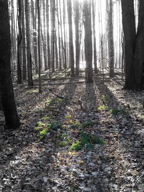
...I like this trail so far. Highbanks Rollway has a lovely view of the Manistee River that you could see from a very involved viewing deck that must have been a lot of work to build. The trail wandered along the bluffs and valleys along the river. I was surprised at how steep and long some of the bluffs actually were.
So that was nice. Wonderful campsites scattered high above the river in this section,

Thursday, October 2/08
Wheeler Creek to Eddington Creek

Slept okay despite lumpy, awkward ground. Woke up, ate, and had great coffee. Rain hit and did not stop for 3 hours. We crossed 37 after a mile in and started a 5 mile roadwalk. Just as we started a little black husky mix began following us. He was a great trail dog-stayed with us, happy and loving. We thought he would go home eventually but... called animal control and they gathered our dog. Best for him and for us though it was sad...
...Salmon and couscous is good.
Goodnight little dog, I hope you're dry and your belly is full.
drying gear
Trying to dry out


Friday, Oct 3/08
Eddington Creek to Hemlock Stand Above Leitch Bayou

Finally! A semi-sunny morning that changed everything. Lovely dappled forest high up on the bluff, and below in the ravine the sunlight was burning up the mist. I accidentally scared a raccoon that was starting to climb a tree. He froze, then ambled away from the trail into the woods. Kind of like now, it's 8 pm, dark, and something is moving around outside our tent, but I don't know what it is and it's freaking me out a little. It's probably just a porkie/raccoon.
Anyway, the trail was high and dry today, ascending and descending through huge ravines on 100% footpath, not even any woods roads...
...We found camp in a lovely stand of huge, healthy, and mature hemlocks like I've never seen. They are about 3' in diameter, tower high, and are full of needles. I can't believe how well this worked out. I love hemlocks. This is a great campsite, and a good end to a hard day.

Saturday, Oct 4/08
Hemlock Stand Above Leitch Bayou to 2 Mi. S. of 9 Mile Bridge

Lots of owls and nighttime animals in our camp, but we woke unscathed...
...We hiked a few hours through sunny skies to Udell Trailhead, which had a water pump and a picnic table, so we tanked up with water and had a yummy hot ramen lunch.
The 6 miles after that were dreamy. The woods were beautiful, open and mature, still green, and completely open underneath. The soil changed to a sandy base, and then pines dominated with a grassy understory. Lovely woods, some sun, a perfect walk. Possibly the best section so far, excepting the parts above the river. I was tired and hurting all over, but this section mentally made me very happy

Sunday, Oct 5/08
2 Mi. S. of 9 Mile Bridge to McCarthy Lake

...After an atrocious-PAVED-roadwalk that made my feet feel split in 1/2, [sorry Tilly, we can’t find any way to make it go away] we found a small grocery/liquor store (more liquor than grocery) that was run by a very nice woman. We were able to get cheese & crackers, snickers, and ramen, which will do for 1 1/2 days. She also, thank God, had Carmex (my lips are a bloody, cracked, chapped mess and look diseased, and it's starting to hurt to move my mouth in order to talk) and AA batteries for my camera.

I loved that little store. It was really cute country store, non-commercial, and sold some used clothing and books, too. In my dreams I could work at a laid back place like that...

Monday, October 6/08
McCarthy Lake to Bowman Bridge Nat'l Forest Campground

Rain and darkness for most of the day. .. The low point hit me at lunch at Pere Marquette River access bridge. I was damp, and a cold wind came through and chilled me further. I watched people who were fly fishing and thought, hey, that's a good hobby. Get out for awhile, enjoy yourself, then go home to warmth, a comfortable couch, and possibly some hot chocolate. After that thought, I ate my pepper-jack and triscuits, and we got back on the trail. I started feeling 100% better, mentally and physically. I guess 4 hours between small snacks is too long.

Tuesday, October 7/08
Bowman Bridge NF CG to Highbank Lk NF CG

We walked the first 5 miles in a steady clip and finished them in 2 hours. The next section of the day was weird for me. I drank too much coffee this morning, and I was feeling lightheaded and not all there (probably from the caffeine crash.) The trail lead us near private property where the path was fenced in on both sides, then along a 3 mile marshy area that had barbed wire, red flagging tape, and No Tresspassing, Private Property, Will Prosecute signs posted every 6 feet. That, along with faint trail (but thankfully excellent blazing) made me want to get out of that section, fast.

Wednesday, Oct 8/08
Highbank Lk NF CG to Nichols Lake

The last 2 miles we slowed the pace and walked through a nice pine stand. Finally Nichols Lake came into view on my left. It is the largest lake we've walked past on this trip, and it is the most beautiful. I was happy to end here. The grey sky reflected flat into the water. The grasses were still, and the area seemed calm, peaceful, and for lack of better words isolated (in a clean, wildernessy way, not in a bad way.) I forgot about being soaked from the inside out and just stared out over the water.
I made Matt check out my car. Still there. All intact. No ticket. Wow. I'll just say that I can't believe how well everything has fallen into place on this trip.

See Tilly Ernisse's Trail Journal at trailjournals.com

Friday, December 5, 2008

Will Add Notices of Special Programs

Thanks to the seven people who voted, I'll announce any special events hosted by chapters, that I know about, here. This won't be a calendar for everything. But programs with speakers, special outdoor events, and things like that appear to be of greater interest than regular business meetings, monthly hikes, etc. So... let me know when you have things planned!

Thursday, December 4, 2008

Missing Hiker in ADK High Peaks Found

rescue of missing hiker
photo from channel 7, Arlington VA
from Channel 7 news, Arlington, VA

A Virginia man who went missing in the Adirondack High Peaks this weekend was found Monday afternoon by DEC forest rangers.

DEC spokesman David Winchell said an emergency dispatcher took a phone call around 3:30 p.m. on Sunday reporting 25 year-old David Robertson of Fairfax, Va. was lost. Robertson was part of a group of five hikers who set out Saturday to climb Mt. Marcy, the state's highest peak.

The five reportedly started hiking up the Van Hoevenburg trail from Adirondack Loj, outside Lake Placid, on Saturday morning... more

Although the North Country Trail will not go through the High Peaks, the lesson here is pertinent. Many people do not realize how wild and dangerous the Adirondacks can be. The NCT will probably be routed through several wilderness areas, and hikers will be assured of genuine backcountry adventures, with all of the associated risks.

A Blaze of Glory on the Link Trail

Link Trail Blazers
from the Link Trail Journal by Hugh Yemen

I assumed that this work hike would involve trail-clearing so I loaded my trunk with axes and machetes. I left Oneida at 8:30, driving west through Clockville and south on Nelson Road. Other than the guy in the Saturn who passed me and the car ahead on a double line, it was a gorgeous, crisp, sunny morning. The valley was filling with more yellows and reds than I've seen around Oneida in years.

Just before 9:00 I pulled into the designated meeting spot: the parking area at the southwest tip of Cazenovia Lake. Then I found out that Kathy Eisele had sent me an e-mail telling me that all we'd be doing was marking trail. It turned out that Yahoo had put her message in my spam folder, so here I was with a trunk full of blades instead of the one thing I needed: a hammer. Thankfully Kathy had at least one extra... more

Note that part of the Link Trail is concurrent with the North Country Trail. Although painted blazes are the standard for the NCT, nail-ups are an allowed alternative.

Plants Take A Hike

by Joan H. Young

Even Plants Use Wildlife Corridors (Trails)

It’s been known for quite some time that natural corridors, trails being an example, can help wildlife move safely from one area to another. Even seed dispersal of some types is aided by corridors.

Researchers at Washington University in St. Louis wanted to know more about how plant movement in corridors happens. They got some predicted results, and one big surprise.

Three common means of seed dispersal include ingestion and defecation by birds, wind dispersal, and unassisted dispersal. In unassisted dispersal the seeds fall near the parent plant. The unassisted seeds are not encased in appetizing fruit or possessing fine hairs or wings which allow the wind to move them.

The study accurately predicted the movement of seeds by the birds along the corridors. Researches did not fare so well with their notions of what would happen to the wind-dispersed seeds. The corridors enhanced the effects of the wind much more than what they expected. "In hindsight, this makes a lot of sense,” said researcher Ellen Damschen. “Wind can be channeled between physical structures. For example, think of when wind speeds up as you walk between tall buildings in a city. Corridors may similarly funnel wind and carry seeds down them.”

But the big surprise was that plants with unassisted seeds also moved along the corridors. The prediction was that the corridors would have no effect at all on certain kinds of plants.

However, "we found a really strong response to corridors, contrary to what we expected," Damschen said. ""We think these plants must be being assisted in some way, and we think it's possibly from mammals. Unassisted plants exceeded our expectations by a long shot."

Their next theory is that mammals are inadvertently eating some of the seeds while foraging. To check this out students are now planting various kinds of mammal scat to see if they sprout.

(Do I dare suggest that higher education sometimes takes some strange turns?)

See the original news release fromWashington University in St. Louis


Wednesday, December 3, 2008

Kekekabic Trail Report

burned area of Kekekabic Trail
Surreal scenery in the burn area

from Martin Kubik

As far as the Kekekabic Trail is concerned, I backpacked it November 6-8. The trail is in sorry shape. In the fire burned down area, in east third, I walked off the trail about half a dozen times, the trail disappears in front of ones eyes! At least two times I ended up bushwhacking cross country to the next land mark. One of those places was the same spot where the two women hikers from Duluth got lost. Without visible tread on ground and without marking it is easy

The central blow down segment is heavily overgrown with brush, sometimes in middle of the trail. The west segment has many treefalls and the balsam fir branches extend into the trail.

I came across several areas that were well brushed, and free of treefalls, but majority of the Kek needs a lot of TLC. My hope is that we can rally volunteers to clear it and the USFS to tolerate temporary marking in the no-man's-land of the burned down area until the tread is reestablished.
see more photos


Tuesday, December 2, 2008

"Treat" a Bug with Toxic Blood

a news release of American Society of Tropical Medicine and Hygiene

Most successful vaccines and drugs rely on protecting humans or animals by blocking certain bacteria from growing in their systems. But a new theory actually hopes to take stopping infectious diseases such as West Nile virus and Malaria to the next level by disabling insects from transmitting these viruses.

Researchers say that vaccines and drugs may be used to prematurely kill ticks, sand flies and mosquitoes, known as disease vectors. These are the insects responsible for most deaths world wide.

The idea is to make blood meals from humans lethal to mosquitoes so they die before they can transmit a disease. Called endectocides, these vaccines are administered to humans. When the pest feeds on the blood it dies. Endectocides are currently mass administered to human populations to control the worm parasites that cause river blindness and are widely used in animals for worm control.

A vaccine is in early development for cattle, whose production is greatly affected by tick-borne diseases. The University of Oklahoma is working on a vaccine to target tick-protective genes, so when ticks feed on immunized cattle, the vaccine antibodies interfere directly with the biology of the tick and its feeding pattern which results in reduced tick populations. The vaccine model being developed for cattle, which is called a dual target vaccine approach because both ticks and tick-borne pathogens are targeted, will likely be applicable to other ticks and the bacteria that they transmit.

Advantages are that these control measures are more targeted than environmental spraying of insecticides; proper application would kill older frequently-biting insects and interrupt disease transmission; resistance would be slower to develop; and there may be little cross-resistance from agricultural applications.

Program - Trail Through Pictured Rocks

from Roy Krantz of the Midland Hiking Club

Speaker and Midland Hiking Club member, Jim Knarr, will present a program on hiking the Lakeshore Trail at Pictured Rocks (incidently rated the number one backpack in Michigan by Jim DuFresne). This is also the route of the North Country Trail. Jim will also talk about dehydrating your own food for the trail.

Additionally, there will be discussion about PBLs (personal locator beacons) and anything else the group wants to talk about.

This Thursday, at the Little Forks Outfitters in Downtown Midland, Michigan, 7 pm.

Garmin Colorado Review

by Joe Dabes (FLT Map maker and 5 time FLT end-to-ender)

Java Joe here. I have purchased six Garmin GPS units (3 field, 3 auto) over the last 7 years, and never been disappointed -- until now. I purchased this Colorado 400t (t for topo), in spite of the poor reviews that I had read. I've had it for just three days, testing it extensively, and it is going back to amazon.com tomorrow for a refund. Do not buy this unit, it has many flaws. If you are considering a field (hiking) GPS unit buy the highly reviewed Garmin GPSmap 60CSx, which many of us have.

Problems with the Colorado:
  1. The very skimpy manual leaves so much out.
  2. Battery life (with 2 alkalines) is only 3 - 4 hours, even with backlighting and electronic (magnetic north) compass turned off. GPSmap 60CSx with same batteries lasts 15 - 20 hours.
  3. After only an hour or two, with new batteries, the unit kept turning itself off when I performed operations on it. Perhaps I had a defective unit, but I have read reviews where this problem is common.
  4. Screen is pretty, but hard to read, as tiny fonts used.
  5. Although I couldn't verify this, some reviewers, mostly from geocachers, found that the track of this unit can be off by as much as 400 - 500 feet (they blamed this on a new chipset). I have always found the 60CSx to be accurate within 10 to 40 feet.

And if you are considering getting our soon to be released (hopefully) FLT track (nearly 900 miles) and TH waypoint files, consider the following:
  1. Along with active (hiking) track, Colorado can show only one saved track (always violet) at a time, 60CSx can show up to 20 saved tracks at a time (in colors similar to the blaze color, except white blazes shown as black).
  2. When this FLT track and waypoint data is available for sale, included instructions will be written for the 60CSx, which a near majority of my so far 11 testers have.

Don't buy this dud Colorado, which costs nearly $500; 60CSx is about $300 and a much better unit. Make sure you also get Garmin MapSource Topo 2008 ($80, and yes, now 25' contour lines, instead of 66 foot (20 meter) contour lines!), so you can load FLT track and waypoint data into the unit, and also save your own tracks and waypoints. Also nice: a 1 or 2 GB micro SD card ($10 - $20) so you can load half to all the U.S. topo maps from Garmin MapSource Topo onto your unit.

Cheers, and Happy Trails, Java Joe

P.S. I just read a number of reviews of the newer Garmin Oregon 400t touch screen field GPS unit. Seems it has problems similar to the Colorado 400t, although battery life may be better. The big complaint about the Oregon was dim screen that is hard to see in sunlight.

Monday, December 1, 2008

Blast Match Fire Starter