Notice: I've taken a part-time job, and it's definitely affecting my blogging time. I'll continue to add content here as often as possible. Pertinent guest posts are always welcome.

-
Showing posts with label Kekekabic Trail. Show all posts

Monday, February 13, 2012

Ham Lake Fire Took More than Trees

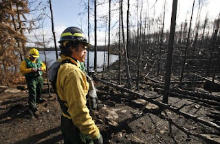
hikers on burned trail
trail area burned by Ham Lake fire in 2007(photo by JHY)

by jhy with an excerpt from the Dartmouth Alumni Magazine

The Ham Lake Fire of May 2007 burned over 75,000 acres in both Canada and the United States in the Boundary Waters region of Minnesota. I burned across two sections of the Kekekabic Trail, part of the NCT.

The fire was accidentally started by life-long camper Steve Posniak. He escaped the fire itself, but became a victim when the Forest Service decided to prosecute him for causing the blaze. He eventually committed suicide, thus becoming the one life lost as a result of the Ham Lake Fire.

An article in the Dartmouth Alumni Magazine tells his poignant story. It begins:

"In preparation for his beloved annual spring canoe trip to northern Minnesota, all winter long Steve Posniak could be seen walking through the alleys of his Washington, D.C., neighborhood carrying 50-pound weights. As a stocky man in his 60s, Posniak wanted to be sure he was strong enough to portage alone, carrying gear on his back and a canoe overhead across miles of trails that connect more than a thousand lakes sprinkled throughout the Superior National Forest. "

Read the rest of the excellent article at the Dartmouth Alumni Magazine


Wednesday, December 21, 2011

Royal River Bluff
Royal River bluff from the Border Route on the Minnesota Arrowhead (photo by jhy)

received from Ed Solstad esolstad@pressenter.com


The Border Route (northern portion of the Minnesota Arrowhead North Country Trail) is doing well in comparison to the other trails, being No. 2 in use for 2009 and No. 1 in 2010 & 2011. In 2009 the Kekekabic Trail was No. 1. The Kek is also part of the NCT, just to the west of the Border Route.

The Forest Service recently issued this report of all Boundary Waters Canoe Area Wilderness trail entry points permits.

In 2009, 2010, and 2011, the Kek had 76, 51, 45 permits issued, respectively.

The Border Route, for the same three years was 42,54, and 55.

Ed says, "Thanks go out to all of you that have helped in our maintenance efforts. Without your dedication, the trail wouldn't be what is is today."

See the full Trail Use Report (an xls file)

This segment is in the Border Route guide

See Border Route Trail

Monday, October 24, 2011

Kekekabic Trail Reopens After Pagami Creek Fire


aftermath of Pagami Creek Fire
Carl Skustad of the U.S. Forest Service surveyed the fire damage near campsite 7 on Lake Three, charred by the Pagami Creek fire. in the BWCA. (photo by David Joles)

based partly on a news article in the Star Tribune

U.S. Forest Service officials took members of the news media on a paddling tour through the Boundary Waters Canoe Area Wilderness last Wednesday, to show them the effects of the Pagami Creek Fire. The burn pattern is called a mosaic, with some places charred and others not.

While the fire is comparable in size to the Ham Lake Fire of 2007, this fire did not burn across the North Country Trail. However, it did close the Kekekabic portion of the NCT because of the close proximity. The Kek is now open again.

The Pagami Creek fire burned across 51 BWCAW campsites, but only 5 are damaged enough that they are expected to be closed next year. Forest Service personnel will go through and cut down snags (leaning trees) which are a major danger after fires. Come spring, new growth will begin covering the black earth.

Over 1000 firefighters worked on the Pagami Creek fire, which is not yet quite 100% contained. The Pagami Creek fire area covered about 145 square miles, about 9.2 % of the entire BWCA. It burned down one structure -- a remote Minnesota DNR cabin.

This segment is in the Kekekabic Trail Guide

See Kekekabic Trail

Saturday, October 8, 2011

New Kekekabic Trail Guide Issued in 2011

Terry Bernhardt with Kekekabic Trail Guide
Terry Bernhardt with the new Kek Guidebook (photo from NCTA)

based on a post on the North Country Trail Association blog

In April of this year, a new and updated guide to the Kekeabic Trail section of the NCT was quietly introduced. The original guidebook was issued in 1996 and needed serious overhauling. Both the big blowdown of 1999 and several fires have impacted the trail since that time.

A Field Grant from the NCTA was used to fund the book. The project was led by Terry Bernhardt (former KTC President), Mark Stange (current KTC President), the author, and NCTA’s Matt Rowbotham who produced the trail maps.

The Kekekabic Trail is the western section of the top portion of the Minnesota Arrowhead. This part of the trail is within the Boundary Waters Canoe Area Wilderness.

This segment is in the new Kekekabic Trail Guide

See Kekekabic Trail Club


Thursday, September 15, 2011

Kekakabic Trail Closed Due to Pagami Fire


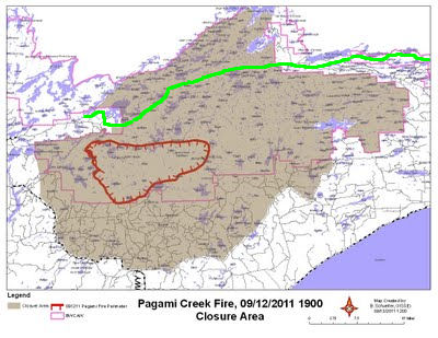
Pagami Fire Closure Area
fire closure area 9/12

from various sources

The Kekeabic Trail has now been closed, as has a large portion of the Boundary Waters Canoe Area Wilderness. For a much larger map with more detail, see the Closure Area Map from the Minnesota Incident Command. This is a pdf.

In the map above, the red outline is the fire perimeter as of Monday evening. The shaded area is the portion of the BWCAW that is closed. The green line is the NCT/Kekekabic Trail.


Wednesday, September 14, 2011

Pagami Fire Update


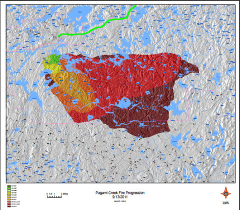
Pagami Creek Fire Map
Pagami Creek fire and NCT (green line)

compiled from various sources

The Pagami Creek Fire has now become larger than the Ham Lake Fire of 2007, but does not appear to be threatening the North Country Trail. The closest the fire approached the NCT was just south of Snowbank Lake near the western end of the Kekekabic Trail, with about two miles of forest between.

At this time, the fire is still spreading to the east. Early on, firebreaks were created to the north and these have held. The fire slowed today with light rain and higher humidity, but it has now reached blowndown timber from the 1999 event, and no one expects this fire will be out for a long time.

Command is now unified under Lake County, Superior National Forest, and Minnesota Incident Command. In addition to four Blackhawk helicopters sent by the National Guard, the province of Manitoba is sending two water bombers and an air attack plane.

Pagami Creek Fire Map
Pagami Creek fire and NCT (green line)

For the most current information, see the Minnesota Incident Command

Tuesday, September 13, 2011

Pagami Creek Fire Burning South of the Kekekabic


Pagami Creek Fire
smoke from Pagami Creek Fire (photo from a video at NorthlandNewsCenter.com)

compiled from various sources

The Pagami Creek Fire, in Minnesota, just east of Ely, is still south of the North Country Trail, but is still growing. The fire began on Aug 18, the result of a lightning strike. It was considered a minor blaze until two days ago when high winds suddenly spread the fire 16 miles to the east, to the edge of Polly Lake.

Most of the Boundary Waters Canoe Area Wilderness remains open, but many access points have been closed. Smoke from the fire has been seen as far east as Illinois, and is affecting air quality. The Pow Wow Trail is closed.

As of this afternoon, the fire has now burned 100,000 acres, and is second only to the Ham Lake Fire of 2007, which burned 120,000 acres, and is considered the most costly fire in Minnesota history. It has been difficult to determine the exact size of this fire area, because of the heavy smoke.

The fire has now spread so quickly that it is threatening to ignite areas which were affected by the 1999 Blowdown where stacked dry wood is like a tinderbox waiting to be lit.

Control of the blaze has now been delegated to a unified command with Lake County Sheriff's Office as full partners of management of the fire. The Governor has called in the Minnesota National Guard and helicopter support. A Red Cross aide station has been established at the Finland Community Center. Finland is a town on the Superior Hiking Trail.

The last map I could find showed this trail still miles south of Snowbank and Parent Lake where the NCT comes out of the woods on to Fernberg Road. But this is definitely one to watch. Earlier today an official incident map was available on line, but now that link seems to have been taken down. I'll add it here if it is put back.


See Kekekabic Trail Club

Thursday, August 4, 2011

Kekekabic Trail Club to Consider Becoming NCT Chapter

Kekekabic Trail Guide

via email from the Kekekabic Trail Club

Given the history and value of the KTC, we are considering options for the future. One option being considered, in order to provide more resources and networking for the KTC, is to become a chapter of the North Country Trail Association. This is an important decision and we want to have your input to the final decision. Our member meeting is Wednesday, Aug. 24, 7 p.m. Make contact for more information.

Matt Davis, Regional Trail Coordinator for MN & ND, North Country Trail Association will meet with us to provide information about being a chapter of the NCTA.

Feel free to share your thoughts with Mark or Terry, about the future of the KTC.

We have a new Kek Trail Guide, but are currently out of copies. More will be printed, with revisions, later this summer.

Contact Terry Bernhardt
or Mark Stange

Thursday, April 22, 2010

Kekekabic Trail Closed- Fire Danger

hikers on burned trail
trail area burned by Ham Lake fire in 2007(photo by JHY)

OutdoorBlips: vote it up!
if you like this article, click the Blip chiclet!
a news release of Superior National Forest

Beginning Friday, April 23, 2010, the Forest Service will close the entire Kekekabic Trail on the Superior National Forest to public use. The closure begins at Snowbank Lake Road: includes Wilderness Entry Point 74, Snowbank Lake Trail, Disappointment Lake Trail and all other associated connector trails and loops, Entry Point 56: and ends at Gunflint Trail County Road 12.

Superior National Forest managers are taking this step in response to the very high fire danger in northern Minnesota. The concern is that hikers could potentially become trapped if a wildfire starts and spreads in remaining blowdown fuels in the interior of the Boundary Waters Canoe Area Wilderness.

The Kekekabic Trail will remain closed until further notice.

This closure is in addition to a Forest-wide prohibition on the use of any campfires, charcoal or wood-burning campstoves on any national forest lands within the Superior National Forest. State and local government have enacted similar restrictions on other lands in northern Minnesota.

For additional information call 218-626-4300 or visit the Superior National Forest web site Superior National Forest or the Minnesota Incident Command System

Sunday, April 4, 2010

See the Kek, Clear Some Trail

trail clearing
2009 Kekekabic trail clearing trip (photo from the KTC)

OutdoorBlips: vote it up!
if you like this article, click the Blip chiclet!
a news release of the Kekekabic Trail Club

The Kekekabic Trail Club has two open trail-clearing trips on the Kekekabic Trail (part of the northern edge of the Minnesota Arrowhead). Both are out of the Ely (Kawishiwi District) Forest Service Center. Typically, crews drive up and assemble the night before, staying at the new Forest Service Center, setting out early Friday morning, and paddling out of the Wilderness and driving home on Monday.

trail clearing
2009 Kekekabic trail clearing trip (photo from the KTC)
May 14-17 Canoe into Thomas Lake

May 21-24 Canoe into Parent Lake

To sign up, send email to mark.stange@uhc.com. Hurry, before they fill!

See Kerfoots Report Hikers Still on Kek
See Scouts Clear the Kekekabic

Friday, December 4, 2009

Kerfoots Report Hikers Still on Kekekabic Trail

Bruce & Sue Kerfoot
Sue and Bruce Kerfoot, owners of Gunflint Lodge (photo by JHY)

OutdoorBlips: vote it up!
if you like this article, click the Blip chiclet!
based on a Club Outdoors Blog entry by Sue Kerfoot

Sue Kerfoot, of the Gunflint Lodge, a popular supply point near the connection of the Border Route and Kekekabic Trails, regularly writes for the Club Outdoors blogs of the Minneapolis Star Tribune. Sue and her husband, Bruce, are the owners the Gunflint Lodge. The lodge operates year-round, and offers various levels of accommodation, for everyone from a resorter to the thru-hiker.

She reports that the lakes are beginning to freeze, although it will be several weeks until the big lakes are solid. Early winter is the best time for skating the small lakes. Cold weather, before the serious snow begins, results in clear ice with no slush. She warns that one should check with local people before skating, as the ice can be extremely dangerous.

Of serious interest to North Country Trail folks, is the following: "Sunday night we had a young couple come through who have been backpacking in the area. They sent a package for re-supply to Gunflint Lodge and stopped by to pick it up. The next leg of their journey is to hike the Kekekabic Trail to Ely. It just seems a little too cold for me to be sleeping out in a tent but we wish them well."

It is definitely heartening to hear that hikers are still out there on this very remote section of trail.

This segment is covered in the Border Route Trail Guide.

See Border Route Trail
See Live Post- What a Hike!

Thursday, September 3, 2009

Scouts Clear the Kekekabic

alt text
'Lost & Found' backpacking the Kekekabic Trail near Strump Lake a month before the trail was cleared by the Scouts (taken by Mother Goose, used with the permission)

OutdoorBlips: vote it up!
written and submitted by Todd McMahan aka TMan

In early June, 'Lost and Found' hiked the Kekekabic Trail with 'Mother Goose' and called its interior section “the Trail of Hell.” Bob Kohlmeier and his family backpacked the interior section of the Kek in late July. “It was very, very recently cleared” Bob said, “Boy, did the foot trail stand out here. You could see every rock in the path.” So who cleared the Kekekabic? It was the Scouts.

More specifically, it was Boy Scouts who participated in the Order of the Arrow’s Wilderness Voyage Program at the Charles L. Sommers Canoe Base. The Canoe Base, generally considered a Mecca of Scouting in the Midwest, is located only about 5 miles from the western trailhead of the Kekekabic Trail. The Wilderness Voyage Program is a two week program where the Scouts do one week of service and then go on a canoe trip in the Boundary Waters on the second week.

Phil Ashford is the Assistant Director of the OA Wilderness Voyage Program. According to Phil, six crews worked on the Kekekabic Trail this summer. Each crew has 9 people – 2 foremen and 7 participants each week. “Our crews started out by the Kek cabin and worked back west towards Ely,” Phil said. “By the end of the summer, they had cleared almost all the way back to Thomas [Rapids]. Let's call it roughly 9 miles.”

One of the obstacles the Crews working on the Kekekabic Trail had was gathering water. “Normally getting water isn't a problem, but the Kek crews would sometimes be several miles away from lake access” Phil said. “The time spent walking to and from just to fill water bottles diverted a significant portion of man hours away from trail clearing.”

Clearing the Kekekabic Trail presented some new challenges for the Wilderness Voyage program. According to Phil, “Another problem was the fact that corridor clearing is not typically the kind of work we've done in the past, so it took our foremen a little bit of time to devise the most efficient strategy for mowing down the alder. And even then, it seemed as though the Kekekabic Crews suffered more broken tools than the other work sites.”

Besides the Crews that worked on the Kek, the Wilderness Voyage program provided crews that cleared several portages in the Boundary Waters. Over 100 Scouts from all over the country participated in the program this summer at the Charles L. Sommers Canoe Base. Of that, 42 participants and 6 staff members worked on the Kekekabic Trail. Cory Mensen, a Forest Ranger for the Kawishiwi District in Ely, coordinated the service projects. He provided the tools from the Forest Service and the training to use the tools.

The Order of the Arrow is an Honor Camper Society of the Boy Scouts of America. Boys participating in the Wilderness Voyage program must be 16 years old and proficient in their outdoor skills.

Find out more about the OA’s Wilderness Voyage program. Be sure to check out their photo gallery

Monday, August 17, 2009

Signs of Passage

trail entering Chippewa National Forest
where the NCT enters the Chippewa NF at the east on County Rd 132 (photo by JHY)

OutdoorBlips: vote it up!

by JHY

The pavement walk from the Chippewa to the Kekekabic is done! My total came in at 183.2 miles (which included a 3-mile detour we had to take one day). Even though there were some beautiful moments, that many miles of pavement will never be my favorite. Here are just some signs of the passage. When we reached the sign that said 15 miles to Ely we felt like we were actually getting somewhere even though there were 2 1/2 more days to walk. Ely is a big hiking/camping/canoeing/biking center and we felt like we were among those who understood instead of being two crazy ladies out walking a hot road.


Now we are headed into the woods today with backpacks to do the final miles I have left on the Superior Hiking Trail.

sign leaving Chippewa National Forest
(photo by JHY)


sign entering Superior National Forest
(photo by JHY)

Ely sign
(photo by JHY)

Kekekabic Trail sign
connecting with the May hike! (photo by JHY)


It's really hard to describe the thrill of connecting with the location where our wilderness hike ended this May. Note the same signpost as in Home, the Hike Was Great!, (with a lot more greenery evident.)


Saturday, July 18, 2009

DYFORYST

Todd McMahon
Todd McMahon (self-photo)

OutdoorBlips: vote it up!
guest post, submitted by Todd McMahon, "T-Man"

I just wanted to write a story about one of my experiences when I hiked the Kekekabic Trail in late May. I had stopped early and camped at the Aganok Falls campsite. It’s a truly spectacular falls, and I took lots of photos. My plan was to get up early and hike out to the Gunflint Trail the next day.

So I got up the next morning and started hiking by 6am. About 15 minutes after I started hiking I got to a place where the trail goes up a gigantic hill. Now, backpacking up a steep hill is not my most favorite thing to do, but I kept on thinking that maybe there would be some incredible views at the top. Maybe I would be able to take some great photos. Well, I made it to the top of the hill, and I did see some incredible views. They were incredibly bad.

I was in the burn zone and everything I could see going forward was burnt. It was very sad. I did hike out to the Gunflint Trail that day, but the whole hike, all 12 miles of it was in the burn zone. And the next day I hiked the Magnetic Rock Trail which is a burnt up landscape, too.

After I came home from my backpacking trip I decided to find some information about the fire on the internet. The fire is called the Ham Lake Fire because it started at a campsite on Ham Lake. It is suspected that a canoeist had left the campsite with his campfire still smoldering. The Ham Lake Fire burned over 75000 acres, and was the largest fire in the Boundary Waters in more than a century.

The Forest Service recommends that all campfires should be drown with water. All the embers should be completely soaked. After reading all this I came up with an acronym. Here it is, DYFORYST. It is pronounced like Die Forest and stands for “Drown Your Fire Or Ruin Your Special Trail.” It’s not the most catchy acronym in the world but it makes a powerful point: drown your fire or the forest will die and your favorite trail will be ruined. It doesn’t matter if it a canoe trail or a hiking trail, it will be ruined. The acronym DYFORYST might just be different enough or weird enough that people will remember it.

The canoeist in question was an avid outdoorsman who loved the Boundary Waters. Maybe he made a mistake or maybe the fire started some other way. We’ll never know exactly what happened on May 5, 2007 on the shoreline of Ham Lake. But if you remember DYFORYST, maybe you can prevent a big fire on the date of your next outing.

Border Route Trail
Kekekabic Trail

Saturday, July 11, 2009

Mother Goose / Lost & Found Do the Kek

campsite on the Kekekabic Trail
campsite on the Kekekabic Trail (photo by Lost & Found)
OutdoorBlips: vote it up!
excerpts from the journal of Lost & Found

Mother Goose and Lost & Found left Ely for the Kekekabic Trail on the morning of June 30. After walking part of the road from Ely to the trailhead they got a ride, and spent the night at Smitty's resort. They started hiking off-road trail the next morning.

Lost & Found reports that the terrain is primary basalt rocks and wet tree roots across the trail. They took a wrong turn and both of them postholed up to the knees in muddy muck. Then they missed a turn to where they planned to camp - Drumstick Lake, so spent the night without water, and had to hike early to reach water for breakfast.

When then reached the Thomas River they found it only knee deep, which was good. It was thigh deep in May when other hikers passed through. But on the spruce lowlands, the trail was overrun with bracken ferns, berry bushes and other plants. The gals had to concentrate on pulling the vegetation off the trail so they would know where to step. There were a lot of steep ups and downs and they also crossed some swampy areas where their shoes sucked muck.
lake in mist on the Kekekabic Trail
morning mist on a lake on the Kekekabic Trail (photo by Mother Goose)


When they reached the Gunflint Lodge, they ordered 8 oz cheeseburgers and fries, and a dark, local brew, then walked on to Heston's Lodge to spend the night.

Mother Goose and Lost & Found eventually decided to skip the Boundary Trail for now. Mother Goose thinks she'll do like Nimblewill and maybe come back to it when it isn't so grown up like spring.

See Mother Goose's journal
See Lost & Found's journal

Saturday, June 20, 2009

T-Man Does the Kek

Todd McMahon
Tman (photo by Todd McMahon)

submitted by Tman (Todd McMahon)

I started out from Ely, Minnesota on Friday May 22 and hiked all of the Kekekabic Trail, and parts of the Border Route and Superior Hiking Trail. Some of the spectacular scenery I experienced included Agamok Falls, Magnetic Rock, Bridal Falls, Stairway Falls, the Rose Cliffs, Cascade State Park and Lookout Mountain.

This was my first extended solo backpacking trip, so I made a few mistakes like underestimating how cold it would be. But overall it was a wonderful trip which I backpacked over 100 miles. The hike ended on June 2 in Lutsen.

War Club Lake
War Club Lake on the Kek (photo by Todd McMahon)


The reason I was out backpacking was that in March I was Laid Off of work for up to six months. I figured I'd take the opportunity to go on a backpacking trip I've always dreamed of.

I may go back and finish the part of the Border Route I missed. The reason I bugged out at Clearwater Lake was my ankle was feeling a little sprainy after I fell when crossing a downed tree. I didn't want to risk trying the Clearwater Lake to Hovland section which is about 45 miles with no way to get out. I know there is a small campground at the Arrowhead Trail on McFarland Lake, but there is no guarantee that anybody will be over there.

Redeemed myself by backpacking from Grand Marais to Lutsen on the Superior Hiking Trail. If I get in trouble there, all I have to do is hike east and I will hit Highway 61. But my ankle recovered and all went well.

NOW THE BIG NEWS, the Border Route is featured in the latest edition of Backpacker Magazine in the best places for solitude article.

That's all for now, Todd McMahon AKA Tman

See all of Tman's pictures
See Hiking the Minnesota Arrowhead

Friday, May 29, 2009

Hiking the Minnesota Arrowhead

hiker on a rocky outcrop
Marie Altenau and Ed Morse on a rocky overlook (photo by JHY)


by JHY

What an awesome hike! I think that we managed to hit the very best time to hike the Minnesota Arrowhead on the northern Superior Hiking Trail, Border Route and Kekekabic Trails. Despite all the horror stories that we have been told, we were able to follow the compacted treadway over the entire 133 miles of the hike.

For all but the Kekekabic Trail we were treated several times a day to rocky outcrops, usually with great views. However, the weather was cold and damp for most of the first 10 days. All those nights were below freezing, and one of the days we walked in snow and a cold wind all day. The picture below is attractive, but we longed for some warmer weather. And before the end of the trip we did seem to really encounter spring.

fog on the hills
fog rising between the ridges (photo by JHY)


All along the Border Route the scenery is just incredible. The views just never seem to stop. The lakes that form the boundary between the US and Canada are stretched below the trail.

hiker overlooking a lake
JHY overlooking the US-Canadian border from the Border Route Trail (photo by RMA)


One of the most fun things that happened was that we encountered Matt Davis leading a group of hikers on the Kekekabic Trail coming west to east. We stopped and chatted with them for about an hour! Believe it or not, we met more hikers on this remote section of trail than we have ever met on any of our other NCT hikes.

See My Quality Day for more details from the hike.

Monday, April 6, 2009

Trail Clearing Opportunity on the Kek

from the Kekekabic Trail Club

Each spring, volunteer groups dedicate blocks of time to the difficult effort of clearing the trails of the Minnesota Arrowhead. Most of the trip leaders immediately filled their trips with individuals from prior trips and personal contacts All but two of the Kekekabic Trail Club Trips have already been filled for 2009. The remaining opportunities are:

May 22–25 (Drive up May 21 from Minneapolis)
NW section of the Pow Wow Trail, base camp on Horseshoe.
Contact Mark Stange 612-508-6695.]

May 29–June 2 (Drive up May 28 from Minneapolis)
Mid-western section of the Kek, starting some distance east of Disappointment, TBD based on another group's finish.
Contact Jason Johnson 651-645-7505

See Kekekabic Trail Club
See Spring BRT Clearing Schedule

Wednesday, February 4, 2009

Forest Service Will Consider Temporary Wilderness Marking on Kek

trail work on the Kekekabic
trail work in March 2008 on the Kek (photo by Martin Kubik)
a news release of Boundary Waters Advisory Committee

The Boundary Waters Advisory Committee (BWA Committee) and US Forest Service officials met recently to discuss trail management in the Boundary Waters Canoe Area in the Superior National Forest.

Last year’s rescue of two Duluth hikers lost on the Kekekabic Trail in the BWCAW, along with the 1999 windstorm, two major fires, and a number of other Search and Rescue operations in the wilderness over the last several years, has moved the Forest Service to reconsider whether trail markers should be placed on indistinct trails in the wilderness. Five hiking organizations, the BWA Committee, the Kekekabic Trail Club (KTC), the Border Route Trail Association (BRTA), the North Country Trail Association (NCTA) and the 3M Club Outdoor Club support marking of a troublesome 13 mile long section of the Kekekabic Trail and segments of the Border Route Trail where the path has been obliterated by the past fire.

At the meeting, the BWA Committee offered, subject to the Forest Service approval, to send out a survey team to locate and reconnect missing links of tread on the Kekekabic Trail. The USFS is presently reviewing several options for wilderness appropriate marking once the trail tread is located. Marking would be temporary and most likely removed once a tread is re-established, through use and by surrounding vegetation, which may take several years.

Both parties agreed that a low number of hikers caused the trails to become obscure. The Kekekabic and other wilderness trails are less then 10 inches wide, overgrown with grass and crowded by brush, raspberries and balsam fir branches. In contrast, portages are worn down to bare gravel and are typically 3 to 6 feet wide.

BWA Committee and the USFS discussed ways to increase volunteer recruitment and train crew leaders. Safety of participants is of paramount importance, since the trail maintenance is done in the wilderness and crew leaders need to have people, safety and outdoor skills.

The BWA Committee, along with the Kekekabic Trail Club, are organizing several BWCA trail maintenance trips on the Eagle Mountain , Brule Lake Trail, Snowbank and Kekekabic trails in 2009. Trip dates will be posted on the BWA Committee site http://www.meetup.com/Friends-of-BWCA-Trails/ and www.kek.org.

The USFS expressed appreciation for “photo essays,” report from survey hikes and trail clearing trips, posted on www.bwac.smugmug.com. “Photo-essays help us see what the trail conditions are like in the wilderness and the work volunteers are doing,” said Jon Benson, USFS wilderness trail manager. “Your work does not go unnoticed,“ concluded Steve Schug, Assistant District Ranger, Gunflint Ranger District.

See Kubik to Speak About the Condition of the Kek
See Lost on Kekekabic Trail – Update

Thursday, January 29, 2009

Bart Smith Warns- Northern Arrowhead is Tough

Bart Smith
Bart Smith (courtesy photo)
an item from NorthernWilds.com, by Shawn Perich Editor, Northern Wilds Media, Inc, undated

In October 2008, Bart Smith completed a 16-year quest to hike all the National Scenic Trails. He was the 9th person to complete the entire length of the NCT. Ed.

Northern Wilds recently received a phone call from Bart Smith, the man featured in our last issue who is hiking all of the National Scenic Trails. He passed through Grand Marais last summer as he hiked the Superior Hiking Trail, which will soon be part of the national North Country Trail. At the time, some local trails were closed due to fire danger, so Bart had to return in the fall to complete his Minnesota hike.

When he returned, he hiked the Border Route Trail and Kekekabic Trail. He called to ask Northern Wilds to warn other hikers that both trails were in poor condition and very difficult to follow.

On the Border Route Trail, which follows the Canadian border east of the Gunflint Trail, he found the past was very brushy and difficult to discern. Although the trail was marked in places with blue plastic flagging, sometimes the ribbons were in the wrong place.

Still, Bart says, “I’m glad I walked the Border Route Trail. The lookouts were spectacular.”

On the Kekekabic Trail, which runs west from the Gunflint to Ely, Bart passed through recently burned areas. He met a party of hikers from the Granite Gear company who were coming from the other direction. He said it was helpful to follow their footprints through the burned area, because the trail was very difficult to follow. He was unable to complete the Kekekabic, because he eventually lost the trail.

See Walking Down a Dream for pictures from Bart's hikes.
Read Bart Smith completes epic adventure