Notice: I've taken a part-time job, and it's definitely affecting my blogging time. I'll continue to add content here as often as possible. Pertinent guest posts are always welcome.

-
Showing posts with label maps. Show all posts

Monday, October 10, 2011

Finger Lakes Trail Website Offers Interactive Map

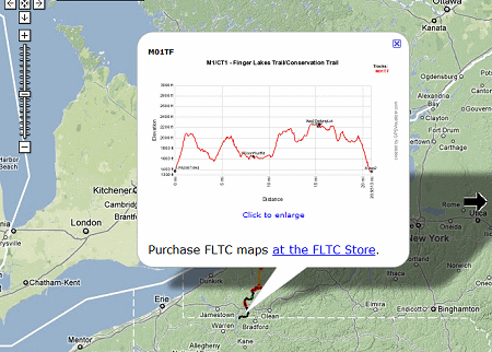
elevation example map for Finger Lakes Trail
example of an elevation profile

from the Finger Lakes Trail Conference

An interactive map for the whole Finger Lakes Trail system of ~950 miles is now online at www.fingerlakestrail.org.

You can zoom in and pan the map. Zooming in twice shows waypoints for trailhead parking, shelters, campsites (including primitive), and hunting closures (red flag waypoints). Clicking on a waypoint brings up more info about it (closure dates for hunting closures).

Clicking on an FLT copyright symbol gives the last revision date for a map and gives a link to the FLT store.

Clicking on a track (main or branch) brings up an elevation profile for that map; this can be enlarged.

Creating this map for over 950 miles of trail is an amazing accomplishment. It will be a great aid to planning hikes. It should be noted that there is much more detailed information on the printed maps, and one should not attempt a long hike without purchasing those.


This refers to the entire Finger Lakes Trail System in NY

See Finger Lakes Trail Conference

Saturday, October 8, 2011

New Kekekabic Trail Guide Issued in 2011

Terry Bernhardt with Kekekabic Trail Guide
Terry Bernhardt with the new Kek Guidebook (photo from NCTA)

based on a post on the North Country Trail Association blog

In April of this year, a new and updated guide to the Kekeabic Trail section of the NCT was quietly introduced. The original guidebook was issued in 1996 and needed serious overhauling. Both the big blowdown of 1999 and several fires have impacted the trail since that time.

A Field Grant from the NCTA was used to fund the book. The project was led by Terry Bernhardt (former KTC President), Mark Stange (current KTC President), the author, and NCTA’s Matt Rowbotham who produced the trail maps.

The Kekekabic Trail is the western section of the top portion of the Minnesota Arrowhead. This part of the trail is within the Boundary Waters Canoe Area Wilderness.

This segment is in the new Kekekabic Trail Guide

See Kekekabic Trail Club


Monday, September 6, 2010

Guide to Hodenpyl Reroute

portion of map of Hodenpyl reroute on North Country Trail

by JHY

The Grand Traverse Hikers Club chapter of the NCTA has worked hard over the past several years to complete about 15 new miles of trail. One could argue that some of it is one of the prettiest pieces of trail in the whole lower peninsula of Michigan. But there have been a lot of questions about finding the new section.

The trail association has issued, this summer, a new edition of the official map MI-05. However, the Grand Traverse Hikers have also created a guide to the section. It includes a general overview map, with trailheads, campsites, and text to describe each section. The entire brochure is available at Northern Exposure and Fletcher Campgrounds. However, the map and guide info is available as a pdf download below.

Also check the Trail Wiki at northcountrytrail.org for a complete description of the section. Please add any comments you have to the Wiki.

This segment is on NCTA map MI-05

See Wiki Guide
See GTHC brochure, p 1 a pdf

Friday, February 5, 2010

NY/NJ Trail Conf Promotes Connection

map of Finger Lakes Trail and Long Path connection point
map of the Slide Mountain area

OutdoorBlips: vote it up!
if you like this article, click the Blip chiclet!
received from Joe Dabes- the FLTC map coordinator

More and more, trails are working hard to promote connections with other trails. So far the North Country Trail has both ends just hangin' out in the breeze, at Crown Point, New York and Lake Sakakawea, North Dakota. There are some high hopes for connections, but nothing yet.

Meanwhile, if you continue east on the Finger Lakes Trail at Cuyler, NY instead of turning north on the Onondaga Trail to follow the NCT, you can hike on into the Catskills and reach the eastern terminus of the FLT.

Long Path Logo
Long Path logo
That ending is a connection with the Long Path, a 347 mile trail which roughly parallels the Hudson River from New Jersey to the Albany, NY area.

The NY/NJ Trail Conference, the maintainers of the Long Path, is releasing their new maps of the Catskills soon and they will be showing the connection with the Finger Lakes Trail. This is the eastern terminus of the FLT, and you can note the small FLT logo on the trail at the left of the map and the LP icon on the Long Path.

See Finger Lakes Trail Conference

Monday, December 14, 2009

USGS Goes to Digital Topo Quads - FREE!

topo map sample
topo map sample

OutdoorBlips: vote it up!
if you like this article, click the Blip chiclet!
from the United States Geological Survey

The United States Geological Survey has long recognized that the time lag between production of their paper maps and known updates was way too long. The standard 7.5' Topo Quads used to be updated every 25 years! Nowadays, people want data updated every 25 minutes!

Soon, you can have just that. Simple go to the USGS web site and use their map interface to locate the map you want. You can view the map in satellite, topo or hybrid mode, and with or without a quad division overlay.

Then, best of all, you can download the file instantly, for free! You also have the option to order a paper map for $8 a quad.

The USGS says, "Arranged in the traditional 7.5-minute quadrangle format, digital US Topo maps are designed to look and feel like the traditional paper topographic maps for which the USGS is so well known. At the same time, US Topo maps provide modern technical advantages [including data layering] that support wider and faster public distribution and enable basic, on-screen geographic analysis for all users."

So far, these digital layers have been produced for 17 states. None of these are North Country Trail states, but every NCT state except Michigan is scheduled for 2010.

See USGS Map Production status

Sunday, November 29, 2009

Map Number to be Added to Posts


OutdoorBlips: vote it up!
if you like this article, click the Blip chiclet!
admin note

map button From now on, all posts will also contain this small graphic, with some text following it. That text will be the name and source of the trail map on which the events in article occur. In some cases, the topic will be more general, or from other trails. In that case, the information will simply not be included.

See Wampum Chapter of the NCTA


Wednesday, February 4, 2009

Another Google Maps Example in the Manistee

example of Google Map
NCT / Manistee River Trail Loop

from Matt Rowbottham, NCTA GIS Coordinator

The NCTA is hoping to use Google Maps to inventory the North Country Trail. It would be an immense task, as is nearly everything associated with this trail. But Matt Rowbottham has high hopes.

This example is a combination of the North Country Trail and the Manistee River Trail in the Manistee National Forest near Mesick, Michigan. This is a highly popular weekend backpacking destination loop. The NCT (west) side of the loop is maintained by the Spirit of the Woods Chapter. The east side is in need of a great deal of work, but a recently formed group, the Manistee River Trail Association, hopes to begin improvements.

Matt says that he's already been sharing data with agencies and volunteers this way. To inventory this 4600 mile trail will be a lot of data. "Maybe we can crash the Google server," Matt joked.

See Spirit of the Woods Chapter
See Manistee River Trail Association
See NCT-MRT Loop on Google Maps
See Cayuga Trails Club Builds Inventory Map with Google

Monday, February 2, 2009

Cayuga Trails Club Builds Inventory Map with Google

Google map segment
mapped section in long map view
from the Cayuga Trails Club

With trail organizations, including the NCTA, needing to work on creating a data base of structures on their trail, the Cayuga Trails Club (CTC) of New York has taken advantage of Google's free Maps program. The CTC maintains about 90 miles of the Finger Lakes Trail system. 23 of those miles are official North Country Trail miles, but more are concurrent without being certified.

With Google Maps the club entered the route of the trail, and then each flag shows the location of a structure. One can zoom in and out, and change the map type from political to terrain, to a satellite view.

Google map segment
mapped segment south of Ithaca, New York, in terrain view


Google map segment
mapped segment southwest of Ithaca, New York, in satellite view


Finally, you can click on any flag, or a list in the sidebar, to see the feature located at that point. Here a group displays some picnic tables.

Google map segment
pop-up box appears when a flag is clicked


Data inventories such as this are not only interesting, but they are becoming increasingly required for groups as they seek funding. If trail organizations can not show specific structures with ages, conditions, replacement timelines and costs, funding may often be denied. The Cayuga Trails Club is to be commended for creating such a great resource.

In addition to the FLT/NCT the club built and maintains the Cayuga Trail on the campus of Cornell University. They conduct hikes on trails in the Ithaca area on a regular basis.

See Cayuga Trails Club Google Map Inventory
See Cayuga Trails Club

Wednesday, January 14, 2009

GPS Data Available for Entire FInger Lakes Trail System

FLT logo
from the Finger Lakes Trail Conference

Over 300 miles of the North Country Trail are concurrent with New York's Finger Lakes Trail. All of those miles are now available on a data disk.

In response to member suggestions, the FLT Conference Maps & Guides Subcommittee studied the feasibility of making FLT track and waypoint data for handheld GPS units available to hikers. The proposal was approved.

You may order a CD containing FLT GPS data, but it must be purchased with a complete set of maps, since GPS data alone is insufficient to provide adequate information concerning the hiking experience (regulations, etc). The cost of the GPS data disk with maps is $65 for members of the FLTC and $52 for members. Sales of maps and data help fund the Finger Lakes Trail.

GPS data for trailheads only is available for free, on the Plan a Hike / End-to-End page of the web site.

For more information contact Joe Dabes, or visit the Finger Lakes Trail Conference web site.